

Results 1 to 1 of 1
Thread Information
Users Browsing this Thread
There are currently 1 users browsing this thread. (0 members and 1 guests)
 LinkBack URL
 About LinkBacks
-
04-30-2014, 08:46 PM #1Senior Member


- Join Date
- Aug 2008
- Location
- PARADISE (San Diego)
- Posts
- 99,040
80 mph wind gusts predicted for SoCal | Wildfire Today
80 mph wind gusts predicted for SoCal | Wildfire Today
Posted on April 29, 2014 by Bill Gabbert
UPDATED at 5:30 p.m. PDT, April 29, 2014:
We have updated information from the National Weather Service about the wind event in southern California that is now predicted to last into Thursday.
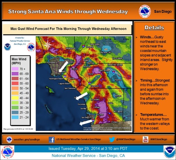
1:14 PM PDT TUE APR 29 2014RED FLAG WARNING FOR LATE TONIGHT INTO THURSDAY EVENING
A RIDGE OF HIGH PRESSURE OVER THE WEST COAST COMBINED WITH OFFSHORE FLOW FROM SURFACE HIGH PRESSURE OVER THE GREAT BASIN WILL BRING MUCH HIGHER TEMPERATURES AND VERY LOW HUMIDITIES WITH POOR OVERNIGHT RECOVERIES THROUGH THURSDAY. THE OFFSHORE FLOW WILL ALSO BRING PERIODS OF STRONG AND GUSTY NORTHEAST WINDS NEAR THE COASTAL MOUNTAIN SLOPES AND ADJACENT INLAND AREAS WITH STRONGEST GUSTS TO AROUND 85 MPH WEDNESDAY MORNING. MODERATE STRENGTH AND LESS WIDESPREAD NORTHEAST WINDS WILL CONTINUE INTO THURSDAY WITH EVEN WEAKER WINDS INTO FRIDAY.
****
(Originally published at 8:30 a.m. PDT, April 29, 2014. Updated at 10:30 a.m. PDT, April 29, 2014 to add a new Red Flag Warning issued at 9:35 a.m. MDT.)
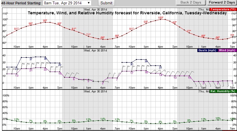 Riverside, CA weather forecast for Tuesday and Wednesday. (click to enlarge)
Wind gusts exceeding 80 mph and single-digit humidities are in the forecast for some areas of southern California Tuesday and Wednesday. A High Wind Warning issued by the National Weather Service at 1:55 a.m. Tuesday predicted sustained winds of 25 to 40 mph with gusts to 80 today, increasing on Wednesday to 30 to 45 mph with gusts to 85. That forecast applies to Orange County coastal areas, San Bernardino and Riverside county valleys, the Inland Empire, San Diego County valleys, and the mountain areas in the counties of San Bernardino, Riverside, and San Diego.
The graphical forecast (above) for Riverside shows relative humidities as low as 6 and 4 percent today and Wednesday, respectively, and high temperatures of 95 and 100.
In spite of this forecast, and live fuel moistures that are typical of July, there is no Red Flag Warning in effect for the area, only a Fire Weather Watch for portions of Los Angeles and Ventura Counties. UPDATE at 10:18 a.m. PDT Tuesday: the NWS issued a Red Flag Warning for portions of Los Angeles and Ventura Counties at 9:35 a.m. PDT
In anticipation of this wind event, CAL FIRE has moved engines and hand crews to the southern part of the state. Air tanker and helitack bases in the area were ordered to be ready to fly at 7 a.m.
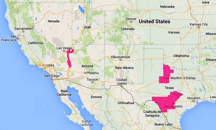 Red Flag Warnings (in red) and Fire Weather Watches (in yellow) areas 8:30 a.m. PDT April 29, 2014
The Red Flag map above was current at 8:30 a.m. PDT, April 29. The revised map below was captured at 10:23 a.m. PDT, April 29, showing all of the Fire Weather Watches had been cancelled, and Red Flag Warning issued for portions of Los Angeles and Ventura Counties.
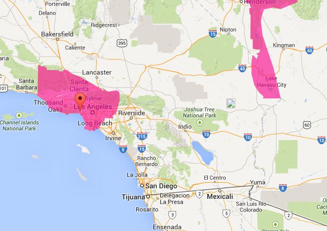 Red Flag Warnings in southern California 10:23 a.m. PDT, April 29, 2014
Near-real-time wind speeds in southern California can be monitored at this NOAA website.
Red Flag Warnings can change throughout the day as the National Weather Service offices around the country update and revise their forecasts. For the most current data, visit this NWS site.
http://www.latimes.com/local/lanow/l...,7230834.story
NO AMNESTY
Don't reward the criminal actions of millions of illegal aliens by giving them citizenship.
Sign in and post comments here.
Please support our fight against illegal immigration by joining ALIPAC's email alerts here https://eepurl.com/cktGTn


 Reply With Quote

Rep. Grothman: DHS monitoring over 600,000 illegals with...
04-23-2024, 07:07 PM in General Discussion