

Results 1 to 10 of 10
Thread Information
Users Browsing this Thread
There are currently 1 users browsing this thread. (0 members and 1 guests)
 LinkBack URL
 About LinkBacks
-
09-08-2018, 01:52 AM #1Senior Member


- Join Date
- Aug 2018
- Posts
- 62,543
STORM WATCH: Odds Rising Florence Will Strike East Coast...
-
09-08-2018, 01:54 AM #2Senior Member
- Join Date
- Aug 2018
- Posts
- 62,543
-
09-08-2018, 01:57 AM #3Senior Member
- Join Date
- Aug 2018
- Posts
- 62,543
Florence may track near Bermuda, US East Coast while it restrengthens in Atlantic
By Alex Sosnowski, AccuWeather senior meteorologist
September 07, 2018, 8:36:21 PM EDT
Video at the page link
Florence is forecast to restrengthen into a hurricane and push close to Bermuda and the United States East Coast. Florence is expected to have indirect impact and may evolve into a serious direct threat.
Florence is a relatively small tropical system, and small tropical systems are very vulnerable to both ideal and poor environmental conditions.
After forming near the Cabo Verde Islands last weekend, Florence became the first Category 4 hurricane of the 2018 Atlantic season as it entered a zone of low wind shear and sufficiently warm waters earlier this week.
Wind shear is the increase in wind speed and change in wind direction with either increasing altitude or over a horizontal distance. Low wind shear can prevent a tropical storm from forming and cause a well-developed hurricane to weaken.
A zone of strong wind shear has caused Florence to weaken to a tropical storm as of Friday. Additional fluctuations in strength are anticipated.

This weekend, wind shear is forecast to diminish, while at the same time Florence moves over much warmer. As a result, AccuWeather meteorologists expect Florence to gain strength.
The movement of Florence is likely to remain steady in the short term, but a deviation in the path may develop next week.
"An area of high pressure over the central Atlantic will bridge westward and join with an existing high pressure near the U.S. East coast over the next several days," according to AccuWeather Hurricane Expert Dan Kottlowski.
"This setup will guide Florence on a west to northwesterly course into next week," Kottlowski said.

If the high pressure area weakens next week, then Florence may be able to curve northward then northeastward out to sea with impacts in the U.S. limited to an indirect nature with rough surf and heavy seas.
However, if the high pressure area remains strong, then Florence may complete a 3,500-mile-long journey over the Atlantic and be guided right into the U.S. East Coast somewhere from the Carolinas to southern New England sometime during Wednesday or Thursday of next week.

Depending on the strength of Florence at that time, such a landfall could have severe consequences in terms of wind damage, coastal storm surge and inland flooding from torrential rainfall. The flood risk would be even higher for areas in the eastern US that have seen rounds of heavy rain in recent weeks.
On Friday afternoon, the governor of North Carolina issued a state of emergency due to the potential threat of Florence.
Gov. Roy Cooper said state emergency management officials are working with local and federal counterparts to prepare North Carolina for possible impacts from Florence
Prior to the chance of Florence reaching the U.S. East Coast, Bermuda may be in the direct path of the storm, even if the storm begins to curve.
If current estimates are correct, "Florence will be in Bermuda waters on Tuesday," Kottlowski said.
RELATED:
Could Florence's track be an outlier in history of Atlantic hurricanes to strike US East Coast?
Helene forms in eastern Atlantic; Will Isaac soon follow?
Photos: Thousands without power, roads shut down as Gordon batters Gulf Coast
5 expert tips for protecting your home against hurricane damage
5 potentially dangerous hurricane preparation myths debunked
An east to northeasterly flow of cooler air will bring rough seas and surf from Virginia to Massachusetts beginning this weekend. However, this will not be directly associated with Florence.
Swells propagating outward will build northwestward a thousand miles ahead of Florence next week.
The swells will make for rough seas along and well off the U.S. coast, Bermuda, the northern shores of the Caribbean islands and the south- and southeast-facing shores of the Canada Maritimes.

The surf may be especially hazardous, since most lifeguards are not on duty past Labor Day. There is the potential for significant beach erosion in lieu of a direct strike.
"While it is too early to change plans, all interests in Bermuda and along the East Coast of the U.S. should closely monitor the movement of Florence over this weekend and next week," Kottlowski said.
If property owners in these areas have not yet prepared for hurricane season and formulated a plan of action, now may be the time. There is the potential that cruise lines may have to alter their itinerary and freighters may have to delay or alter their routes.
https://www.accuweather.com/en/weath...antic/70005975
-
09-08-2018, 03:13 PM #4Senior Member
- Join Date
- Aug 2018
- Posts
- 62,543
US East Coast On Alert As Tropical Storm Florence Poised To Strengthen

The pipeline is full! Hurricane Florence is likely next week, then Helene and Isaac have moved into the tropical Atlantic, and a couple more tropical waves in Africa are moving west.
Sat, 09/08/2018 - 14:15
US East Coast On Alert As Tropical Storm Florence Poised To Strengthen

The 5 am National Hurricane Center (NHC) Report has indicated that the risk for a direct impact from Tropical Storm Florence has increased, although exactly where on the East Coast remains uncertain. Residents of the East Coast should be on heightened alert for the potentially dangerous storm, which is expected to become a major hurricane again in the next 12 to 24 hours as it approaches the US.

Still almost 1,500 miles from North Carolina's Outer Banks, the tropical storm remains 5 to 7 days from a direct US landfall, according to the NHC. As of Saturday morning, Florence had winds of 65 mph and was moving to the west at 9 mph. The center of the storm was about 840 miles southeast of Bermuda.

The latest NHC forecast shows Florence approaching the US East Coast as a powerful Category 4 hurricane with 145 mph winds early next week.
Heavy rain could cause catastrophic flooding well inland from where the storm makes landfall, which is possible anywhere from Florida to New England, AccuWeather said.
The path of Florence is likely to remain steady for the next several days, but a deviation in the storm's trajectory could develop as it approaches the Eastern Seaboard.
"An area of high pressure over the central Atlantic will bridge westward and join with an existing high pressure near the U.S. East coast over the next several days," said AccuWeather Hurricane Expert Dan Kottlowski.
"This setup will guide Florence on a west to northwesterly course into next week," Kottlowski said.
If the high-pressure area weakens next week, then Florence could curve northward then northeastward out to sea with impacts in the US limited.
AccuWeather: Track Scenario 1

However, Kottlowski said if the high-pressure remains strong, then the storm would make landfall somewhere between the Carolinas to southern New England sometime during Wednesday or Thursday of next week.
AccuWeather: Track Scenario 2

The Weather Channel said that "all interests along the U.S. East Coast from Florida to New England should monitor closely the forecast of Florence. If you live in a hurricane-prone location, make sure you have a preparedness plan in place now, before any watches or warnings are issued."

The hurricane center warned that "swells generated by Florence are affecting Bermuda and will reach portions of the U.S. East Coast over the weekend. These swells are likely to cause life-threatening surf and rip current conditions."
If you have not been paying attention, the tropics are extremely busy right now. There could be as many as three named storms in the next several days.

The pipeline is full! Hurricane Florence is likely next week, then Helene and Isaac have moved into the tropical Atlantic, and a couple more tropical waves in Africa are moving west.

While it is certainly not time to press the panic button by the end of the weekend, meteorologists will have a better grasp of where Florence is headed. As of right now, models show the East Coast could get slammed.
https://www.zerohedge.com/news/2018-...sed-strengthen
-
09-09-2018, 02:53 PM #5Senior Member
- Join Date
- Aug 2018
- Posts
- 62,543
-
09-10-2018, 10:10 AM #6Senior Member
- Join Date
- Aug 2018
- Posts
- 62,543
Hurricane Florence Rapidly Intensifying, Likely to Strike East Coast With Life-Threatening Storm Surge, Destructive Winds, Major Rainfall Flooding
weather.com meteorologists
Published: September 10, 2018
Hurricane Florence is rapidly intensifying southeast of Bermuda and is likely to lash the East Coast later this week with life-threatening storm surge, destructive winds and massive inland rainfall flooding in one of the strongest strikes on this part of the East Coast on record.
If you're in the East Coast threat zone, the time is now to develop or firm up your hurricane preparedness plan and be ready to implement it if necessary.
(LATEST NEWS: States Declare Emergencies)
Current Status
As of Monday morning, Florence was still more than 600 miles southeast of Bermuda, moving west-northwest.
Current Storm Status
Conditions in the atmosphere and ocean, including decreased wind shear and warm sea-surface temperatures, have improved, and should allow Florence to rapidly intensify into a major hurricane Category 3 or stronger on the Saffir-Simpson Hurricane Wind Scale later Monday.
This is the second time Florence has undergone rapid intensification, doing so also last Tuesday and Wednesday before wind shear weakened it temporarily.
Florence has generated swells that are affecting parts of the U.S. East Coast. Swells are also propagating to Bermuda and north- and northeastward-facing coasts of the Lesser Antilles, Puerto Rico, Hispañiola, the Turks and Caicos and the Bahamas.
These swells will produce life-threatening surf and rip current conditions at these beaches.
(MORE: Hurricane Central)
Track Forecast
While there still remains some uncertainty in the precise track of Florence, a destructive strike on the East Coast is likely.
The key to Florence's path hinges on the strength and westward extent of a dome of high pressure aloft, which is developing and will strengthen north of Florence over the western Atlantic Ocean Monday and Tuesday.
That bullish high-pressure ridge is expected to be strong enough and far enough west to push Florence to the Southeast coast.

Projected Path
Where Florence turns northward around the western periphery of that high-pressure system will determine what part of the coastline experiences the worst wind and storm-surge impacts typically near the eye.
The National Hurricane Center is forecasting Florence to be a major hurricane (Category 3 or 4) when it arrives at the Southeast coast Thursday. Florence may become only the fourth Category 4 hurricane to make landfall along the U.S. East Coast north of Georgia, joining Hugo (1989), Gracie (1959) and Hazel (1954), according to the historical database.
Here is what we know right now about Florence's track timing. All of this is subject to change in the days ahead, so check back for updates.
- Timing: The peak impacts from Florence are expected Thursday. Tropical storm-force winds may arrive as soon as Wednesday night, but most certainly by Thursday morning along the Southeast coast in the general area of the forecast path. Impacts from Florence, particularly heavy rain, may continue into next weekend or early next week, if it stalls out for a time, as suggested by forecast guidance.
- Locations Potentially Affected: Areas from southeastern Virginia to the Carolinas are most likely to see the first impacts from Florence. As mentioned earlier, it's too early to know specific impacts for this stretch of coastline. Locations farther south, such as Georgia and northeast Florida and farther north into the mid-Atlantic should also monitor Florence for any forecast changes.
Potential U.S. Impacts
We cannot pinpoint exact areas that will see the worst impacts from storm surge, wind and rainfall flooding. However, some potential impacts are coming into a bit more focus.
- Coastal Impact: A destructive storm surge will accompany the eye coming ashore Thursday. It will be highest to the north or northeast of where the center comes ashore. Large, battering waves will ride atop this surge. Significant beach erosion is also likely on the southeastern U.S. coast.

Model Forecast Wave Heights
- Wind Impact: Numerous downed trees and long-lasting power outages could occur near and inland from where the center of Florence strikes. This threat of tree damage and power outages may also extend across Florence's larger swath of tropical-storm-force winds. Structural damage to homes and buildings is possible, particularly where the core of any hurricane-force winds moves through.

Tropical-Storm-Force Wind Probabilities
- Rainfall Impact: Florence could not only produce heavy rain along the coast, but also farther inland across the Carolinas and mid-Atlantic. That heavy rain threat may last for days if Florence stalls out into next weekend or early next week, as suggested by some forecast guidance. If that stall occurs, disastrous flooding could occur in some areas. See the link below for more information.
(MORE: Potentially Disastrous Inland Flooding Possible)

Florence Rainfall Outlook
The name Florence has been used for Atlantic tropical storms and hurricanes since 1953. Unfortunately, the destructive potential of this iteration may mean the name Florence may be retired from future use.
Check back with weather.com for updates on Florence's forecast.
https://www.wunderground.com/news/sa...-us-east-coast
-
09-10-2018, 10:19 AM #7Senior Member
- Join Date
- Aug 2018
- Posts
- 62,543
-
09-10-2018, 10:23 AM #8Senior Member
- Join Date
- Aug 2018
- Posts
- 62,543
Hurricane Florence "Nightmare Scenario" Could Be "Worst Natural Disaster" For Carolinas And Virginia

"Hurricane Florence may end up being the worst natural disaster in recorded history for the Carolinas and Virginia. 3 to 4 feet of rain, IF predictions hold!"
Mon, 09/10/2018 - 10:12
The latest report from the National Hurricane Center (NHC) indicates that Hurricane Florence is on the verge of becoming a monster storm, which strengthened rapidly overnight as it continued to gain strength over the Atlantic, 625 miles southeast of Bermuda.
Florence had maximum sustained winds of 105 mph and was moving west-northwest at nine mph, making it a Category 2 hurricane, the NHC said. An increase in maximum sustained wind speed is expected over the next several days, as government officials from the Carolinas to the Mid-Atlantic on Monday were preparing for a direct hit later this week.
Rapid strengthening is forecast, and Florence is forecast to become a major hurricane this morning and is expected to remain an extremely dangerous major hurricane through Thursday, the NHC said.

Over the weekend, South Carolina Governor Henry McMaster declared a state of emergency in anticipation of a direct hit. The declaration allows the state to use the National Guard for preparations and to aid in search and recovery operations in the aftermath. North Carolina and Virginia have taken similar measures.Hurricane #Florence updateChuck Watson, a disaster researcher at Enki Research in Savannah, Georgia, told Bloomberg that the northern coast of South Carolina and the Outer Banks of North Carolina are likely to be the areas most impacted by the storm, which could cause $15.32 billion in damage if it stays on its current trajectory.
Increasing risk of life-threatening impacts: storm surge at coast, flooding inland
Dangerous winds could down trees & cause power outages
Landfall may be Thurs. If slows after landfall may cause heavier rain & winds.
Stay tuned for #ncwx pic.twitter.com/YIN6OLA1KC
NC Emergency Managem (@NCEmergency) September 10, 2018
Watson said the Gulf Stream is driving warm water past Cape Hatteras, which could create a nightmare scenario that could lead to as much as $25 billion in damages.
Somebody is going to suffer devastating damage if this storm continues as it is currently forecast, Dan Miller, a meteorologist with the National Weather Service in Columbia, told The State newspaper.
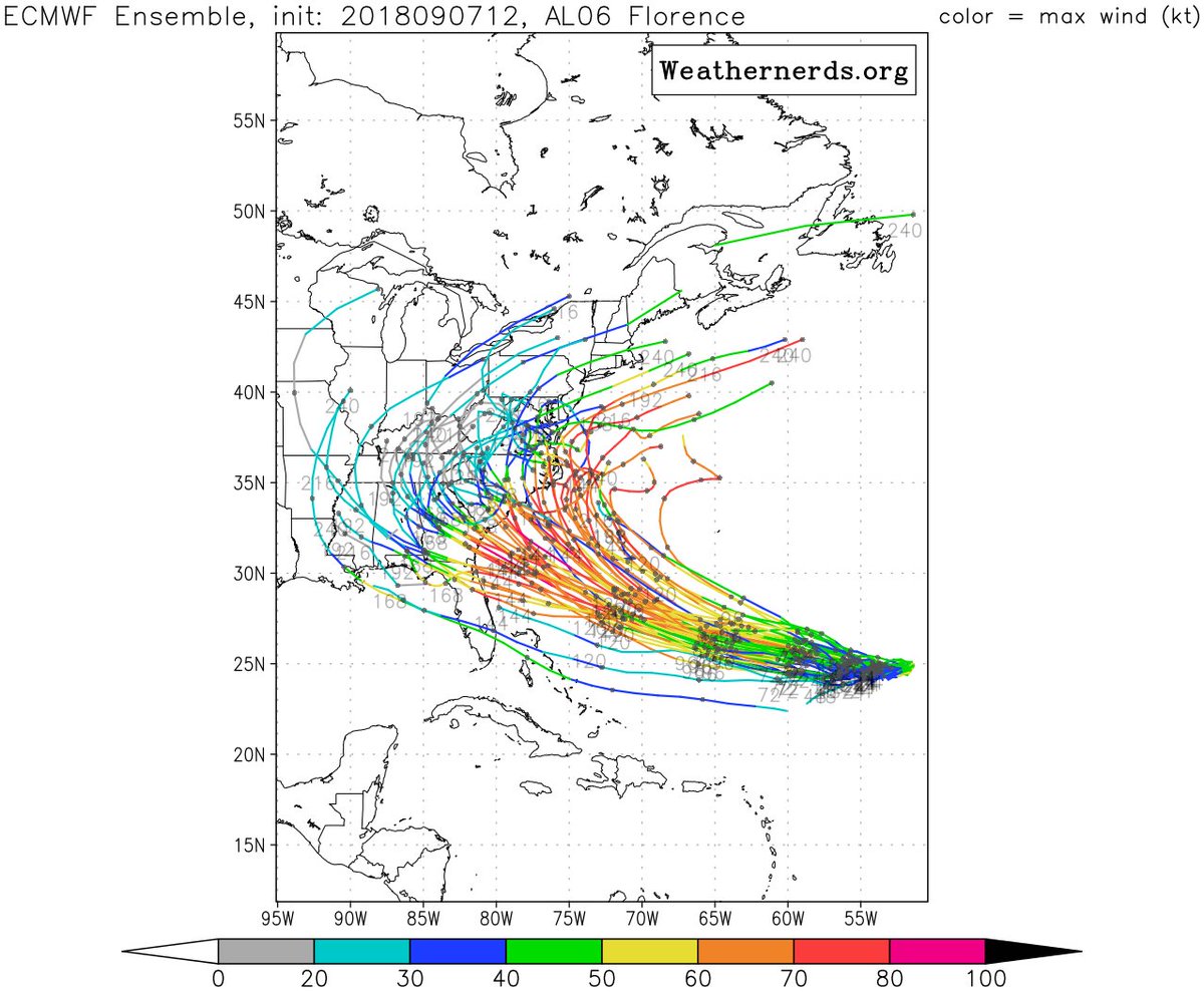
Meteoroglists have said it is still too early to predict Florence's path exactly but warned that many computer models point to a direct hit in the Carolinas by Thursday.
Hurricane Florence Model Track Guidance

What are meteorologists tweeting?
"The leftward solution from the most reliable ECMWF model for Hurricane Florence is centered just south of SC|NC border. The actual landfall point will matter but large size of storm means coast from Charleston, SC to NC Outer Banks should prepare for hurricane conditions," said Ryan Maue, meteorologist @weatherdotus.The landfall location of Hurricane #Florence is still uncertain to 100-200 miles. Complicating will be very SLOW movement Thurs-Fri exacerbating extreme rainfall."Florence is heading for the Carolinas. Florence will likely be a major hurricane. This is happening folks. If you or anyone you know is in the path of this storm, preparations need to be completely finished by Wednesday," said Ed Valle, meteorologist Vallee Wx Consulting.
GFS model (reliable thru 5-days) is a rightward solution over NC.
(GIF: https://t.co/XcmEbEJxko) pic.twitter.com/uUN2E85SYu
Ryan Maue | weathermodels.com (@RyanMaue) September 10, 2018#Florence is heading for the Carolinas. Florence will likely be a major hurricane. This is happening folks. If you or anyone you know is in the path of this storm, preparations need to be completely finished by Wednesday. pic.twitter.com/VX2xVJy9eJ"Hurricane Florence is still on track to make landfall in North Carolina on Thursday as a Category 4 -- becoming the strongest hurricane to ever make landfall north of South Carolina," said meteorologist Eric Holthaus.
Ed Vallee 🌽 Vallee Wx Consulting 🌾 (@EdValleeWx) September 10, 2018OK you guys, my intention is not to scare anyone with this message.As shown above, the spaghetti model projections are unanimously showing the storm will be unusually intense and slow-moving two attributes that indicate its destructive potential, said Axios. While Florence is a Category 2 storm Monday morning, forecasters expect the storm to rapidly intensify to a Category 4 or possibly even Category 5 hurricane as it moves toward the East Coast.
But Hurricane #Florencethe storm bound for North Carolinais going to be about the size of North Carolina when it arrives.
This is what it will look like, according to the latest high-res model prediction: pic.twitter.com/B8vCm3FDi6
Eric Holthaus (@EricHolthaus) September 10, 2018Hurricane Florence may end up being the worst natural disaster in recorded history for the Carolinas and Virginia. 3 to 4 feet of rain, IF predictions hold! BIG news week developing..."This storm will bring a wide array of hazards to the East Coast, and residents of the Carolinas and mid-Atlantic region, including the Washington, D.C., area, are being urged to prepare for a potentially life-threatening event featuring damaging winds that could last for a long duration along with coastal and inland flooding. Florence has the potential to be a large hurricane, with impacts felt hundreds of miles from the landfall location," said Axios.
MATT DRUDGE (@DRUDGE) September 10, 2018

Two other hurricanes are in the Atlantic Basin and will need to be closely monitored this week. According to Philip Klotzbach (Colorado State University), as per Meteorologist Paul Dorian Perspecta, Inc., this is the 11th year on record that the Atlantic Ocean has had 3+ hurricanes simultaneously (Other years were 1893, 1926, 1950, 1961, 1967, 1980, 1995, 1998, 2010, and 2017).

Florence could very well be the "worst natural disaster in recorded history for Carolinas and Virginia," as many Trump supporters hope the storm shifts a tad north into Washington, D.C. and if not drains the swamp, then at least floods it.
https://www.zerohedge.com/news/2018-...aster-recorded
-
09-10-2018, 02:47 PM #9Senior Member
- Join Date
- Aug 2018
- Posts
- 62,543
"It's Like The Zombie Apocalypse" - Water, Batteries, Flashlights Vanish From Shelves As Carolinas Brace For Florence

In some areas, evacuations have already begun...
Multiple tweets with videos and photos at the page link; too many to repost
https://www.zerohedge.com/news/2018-...arolinas-brace
-
09-10-2018, 08:35 PM #10Senior Member
- Join Date
- Aug 2018
- Posts
- 62,543


 Reply With Quote

Similar Threads
-
Powerful Hurricane Florence Could Threaten US East Coast Next Week "Very concerning
By Airbornesapper07 in forum Other Topics News and IssuesReplies: 0Last Post: 09-05-2018, 10:04 PM -
Rising sea 'could ruin east coast in 30 years'
By JohnDoe2 in forum Other Topics News and IssuesReplies: 0Last Post: 09-28-2014, 03:59 PM -
Winter Storm: 8 DEAD IN STORM ACROSS WESTERN U.S.; HIT EAST COAST FOR THANKSGIVING
By AirborneSapper7 in forum Other Topics News and IssuesReplies: 1Last Post: 11-25-2013, 12:25 AM -
As East Coast recovers a new, lesser storm is on the way
By JohnDoe2 in forum Other Topics News and IssuesReplies: 1Last Post: 11-03-2012, 11:55 AM -
Hybrid of Sandy, winter storm eyes East Coast
By kathyet in forum Other Topics News and IssuesReplies: 0Last Post: 10-25-2012, 10:17 AM


As Sen. Cortez Masto Scuttles Mayorkas' Impeachment, Illegal...
04-18-2024, 06:27 AM in Americans Killed By illegal immigrants / illegals