

Results 1 to 3 of 3
Thread Information
Users Browsing this Thread
There are currently 1 users browsing this thread. (0 members and 1 guests)
 LinkBack URL
 About LinkBacks
-
01-26-2014, 04:34 AM #1Senior Member


- Join Date
- May 2007
- Location
- South West Florida (Behind friendly lines but still in Occupied Territory)
- Posts
- 117,696
Drudge Report: Cold of the Century
Join our efforts to Secure America's Borders and End Illegal Immigration by Joining ALIPAC's E-Mail Alerts network (CLICK HERE)
-
01-26-2014, 04:36 AM #2Senior Member
- Join Date
- May 2007
- Location
- South West Florida (Behind friendly lines but still in Occupied Territory)
- Posts
- 117,696
Northeast Snow Next Week Includes Possible Coastal Storm
A string of Alberta Clippers could bring plenty of wintry weather
By AccuWeather
Saturday, Jan. 25, 2014
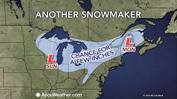
A storm that has a chance of bringing accumulating snow to a part of the Northeast will occur late Sunday into Monday. Another potential storm for the middle of next week is also being monitored.
The train of Alberta Clipper storms that began a couple of weeks ago will continue into early next week. Prior to dipping into the United States, the storms pass over the western and prairie provinces of Canada, where they get their name. Most of these storms are moisture-starved.
The pattern will have yielded close to a dozen clipper storms by this weekend. These storms have been of various strength and have taken a variety of paths.
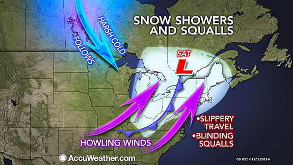
After a large, strong clipper storm blasts the Great Lakes and a large part of the Northeast with wind, snow and whiteouts into Saturday night, yet another clipper storm is due to sweep the area.
This clipper is scheduled to take a track across the Great Lakes Sunday and Sunday night, then the St. Lawrence Valley and northern New England on Monday. A few inches of snow will fall along the clipper's path.
Any snow that flies along the I-95 corridor from Boston to New York City to Washington, D.C., will be in the form of flurries.
The harsh cold in the wake of this clipper could rival prior arctic blast's as the coldest so far this winter.
RELATED:
Will It Snow on Feb. 2 in East Rutherford, N.J.?
Temperature Forecast Maps
Winter Weather Center
Yet another storm may affect part of the East Coast prior to the big game at East Rutherford, N.J.
According to AccuWeather.com Senior Meteorologist Bernie Rayno, "We have to watch for a storm trying to make a run up along the Atlantic Seaboard during the middle of next week."
Rayno is concerned that upper-level steering winds will change next week. While the change in jet stream winds would end the long train of Alberta Clipper storms, it could mark the beginning of a pattern favoring a different breed of storms, which move up from the South.
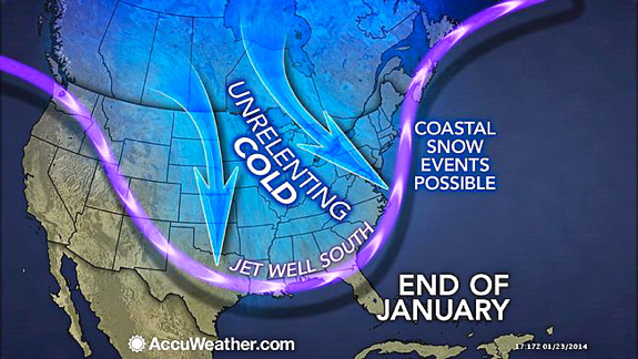
There would still be plenty of cold air in place for snow if such a storm were to hug the coast, rather than head quickly out to sea. Storms that typically move up from the South pack a great deal of moisture from both the Gulf of Mexico and the Atlantic Ocean.
Enough cold will also be present farther south for this possible storm to bring snow to the eastern Carolinas.
However, that cold could be so expansive that the storm waits to develop until well off the East Coast or its track is kept well away from the Northeast coast.
In the wake of a midweek storm threat, another clipper system may return snow showers and flurries to the Northeast on Thursday.
Details on the track and intensity of the storms and the extent of disruptions to travel and other daily activities next week will be made available as soon as possible on AccuWeather.com.
RELATED ON SKYE: 15 Photos of Monster Blizzards

http://weather.aol.com/2014/01/25/no...6pLid%3D434707Join our efforts to Secure America's Borders and End Illegal Immigration by Joining ALIPAC's E-Mail Alerts network (CLICK HERE)
-
01-26-2014, 04:37 AM #3Senior Member
- Join Date
- May 2007
- Location
- South West Florida (Behind friendly lines but still in Occupied Territory)
- Posts
- 117,696
More snow is on its way across the U.S.
The train of storms that began a few weeks ago will continue into early next week.
Areas of the country in its path
More from Skye
Pics of surfers riding giant waves
Satellite image of snow covering Mid-AtlanticJoin our efforts to Secure America's Borders and End Illegal Immigration by Joining ALIPAC's E-Mail Alerts network (CLICK HERE)


 Reply With Quote

72 Hours Till Deadline: Durbin moves on Amnesty
04-28-2024, 02:18 PM in illegal immigration Announcements