

Results 1 to 2 of 2
Thread Information
Users Browsing this Thread
There are currently 1 users browsing this thread. (0 members and 1 guests)
 LinkBack URL
 About LinkBacks
-
06-25-2015, 02:30 PM #1Senior Member


- Join Date
- Aug 2008
- Location
- PARADISE (San Diego)
- Posts
- 99,038
Giant earthquakes are shaking Greenland
Giant earthquakes are shaking Greenland and scientists just figured out the disturbing reason why
By Chris Mooney June 25 at 2:03 PM

The surface of Helheim Glacier is incredibly rough and large. (Credit: Nick Selmes, Swansea University)
If Greenland goes, it is becoming clear that it wont go quietly.
Scientists have already documented entire meltwater lakes vanishing in a matter of hours atop the vast Greenland ice sheet, as huge crevasses open beneath them. And now, theyve cast light on the mechanisms behind another dramatic geophysical effect brought on by the rumbling and melting of this vast mass of often mile-thick ice: earthquakes.
In a new paper in the journal Science, a team of researchers from Swansea University in the UK, the Lamont-Doherty Earth Observatory at Columbia University, and several other institutions explain how the loss of Greenlands ice can generate glacial earthquakes. In brief: When vast icebergs break off at the end of tidal glaciers, they tumble in the water and jam the glaciers themselves backwards. The result is a seismic event detectable across the Earth.
These are all around magnitude 4.6 to 5.2, theyre all pretty close to magnitude 5, says Merideth Nettles of the Lamont-Doherty Earth Observatory at Columbia University, a co-author of the study. Which is a pretty big earthquake.
Granted, these earthquakes arent caused by faults theyre caused by massive movements of ice and how those impact the ground beneath. Compared with the early 1990s, Nettles says, scientists are now measuring seven times as many of these glacial earthquakes coming from Greenland the rate has shot up as the ice sheet has begun to lose more mass from the calving of icebergs at the front end of glaciers.
To understand the dynamics behind how these glacial earthquakes are happening, the researchers put GPS instruments atop Greenlands fast moving Helheim Glacier, which is located in the southeast part of Greenland, across the Denmark strait from Iceland. They also monitored the glaciers calving front, where it meets the water, by camera, and used global seismic data to track earthquake occurrences.
To get a better sense of what they discovered, you first have to wrap your mind around how big these calving icebergs actually are. The amount of ice mass that breaks off in large iceberg calvings from Helheim Glacier, explains Nettles, is around a gigaton, or a billion metric tons. If you took the whole National Mall, and covered it up with ice, to a height about four times as high as the [Washington] monument, says Nettles, youd have about a gigaton of ice. All the way down from the Capitol steps to the Lincoln Memorial.
Measured in space rather than mass, a big iceberg breaking off Helheim can be 4 kilometers in length or over two miles. So maybe it is no surprise that a body this large can shake the Earth when it moves and especially when it throws its weight against another solid object, as occurs during iceberg calving.
The iceberg, when it breaks off from the glacier front, is tall and relatively thin (compared with the glacier, anyway) and in effect standing up vertically. If you could see a cross section of what was happening when it breaks off, it might look like cutting a fairly thick slice from a loaf of bread. But as soon as the iceberg is detached, it quickly begins to capsize.
As that happens, its top (above water) falls and pushes back against the glacier, even as its bottom (below water) rises up to the surface, eventually leaving the iceberg floating flat in the water. Or at least, thats the usual process. Heres a video of the process being simulated, by the researchers, in a tank:
Emory University lab simulates capsizing with plastic glacier(0:4
In this video, which has been slowed down by five times its real speed, a plastic iceberg undergoes capsizing while being digitally tracked through two black dots. The rigid wall to the right measures the hydrodynamic pressure in the water, which plays a major role in the source of glacial earthquakes generated by iceberg capsize. (Justin C. Burton and L. Mac Cathles)
During this capsizing, two massive forces are generated. The first and most obvious one occurs as the tumbling top of the iceberg pushes against the glacier, and actually drives the sheet of ice backwards and inland. During the earthquakes, the region near the calving front shows a dramatic reversal of flow, moving upglacier for several minutes while simultaneously moving downward, the authors write.
The horizontal and vertical motion then rebound rapidly, they continue. But in the meantime, its enough to shake the Earth. That calving iceberg is pushing the remaining part of the glacier backwards hard enough that we can actually measure that, hard enough that it reverses the whole flow of the front of the glacier temporarily, says Nettles. And its that force pushing on the remaining glacier and the rocks beneath it that gives us the seismic [activity].
Theres also a second force involved. As the iceberg separates from the glacier, that opens up a gap for water to rush into. The region has lower water pressure, so that lessens the push of water and ice downward on the Earth. And this results in an upward force acting on the solid Earth, as observed in our seismic analysis, note the researchers.
As if all of this not enough, the events also create a big tsunami, says Nettles. This occurs as the tumbling and rolling iceberg pushes water outwards through the fjord leading up to the glacier. The tsunami is caused because the iceberg has to move a lot of water out of the way as it tips over, Nettles explains.
Setting aside the drama of tsunamis and glacial earthquakes, whats most fundamental is how all of this contributes to rising seas because of course, it is happening over and over again. Over 55 days in the late summer of 2013, the researchers observed ten large calving events and corresponding earthquakes and a total retreat of Helheim Glacier by 1.5 kilometers. And Helheim is just one of many Greenland glaciers that are losing ice.
Each gigaton sized iceberg would be equivalent to roughly a quarter of a percent of Greenlands estimated 378 gigaton annual ice loss. It takes 360 gigatons to raise the global sea level by a millimeter, so Greenland is doing that roughly annually, as icebergs fall into the sea and glaciers retreat further. (In all, the ice sheet contains enough water to raise global sea levels by 6 meters, or 20 feet)
The loss of ice occurs both through iceberg calving which explains almost half of Greenlands total loss, according to the new study and mechanisms like simple drainage. Here, as meltwater atop the ice sheet finds ways of flowing down to its base (sometimes through sudden lake drainage), it then makes its way to the ocean. But both mechanisms have their explosive elements earthquakes, tsunamis, lake vanishings albeit in very different ways.
The earthquakes are not themselves destabilizing the ice sheet, says Nettles, but they are a marker of the fact that the ice sheet is getting smaller and retreating.
And thats where the admittedly tiny piece of good news from all of this comes in. Because these earthquakes are so big, and detectable anywhere with seismic equipment, they can actually be used to track how much ice Greenland is losing. Theyre like the pulse of ice loss. So because Greenland will not go quietly, at least we will know how fast it is leaving us.
http://www.washingtonpost.com/news/e...ng-reason-why/
NO AMNESTY
Don't reward the criminal actions of millions of illegal aliens by giving them citizenship.
Sign in and post comments here.
Please support our fight against illegal immigration by joining ALIPAC's email alerts here https://eepurl.com/cktGTn
-
06-25-2015, 03:32 PM #2Senior Member
- Join Date
- Aug 2008
- Location
- PARADISE (San Diego)
- Posts
- 99,038
Alaskas Glaciers Seen as Major Source of Sea Level Rise
- Published: June 25th, 2015
By Chelsey B. Coombs
The ice that tumbles into the ocean along Alaskas coastline often makes for dramatic images that show one of the ravages of climate change melting tidewater glaciers that contribute to sea level rise. But a new study finds that far more meltwater is flowing into the sea from a similar, if less frequently photographed source inland glaciers.
Compared to their coastal counterparts, inland glaciers account for 95 percent of glacial mass loss due to climate-driven melting, a study published this month in Geophysical Research Letters shows. In fact, researchers found that Alaskas glaciers are melting so fast that they would cover the state with a 1-foot thick layer of water every seven years.
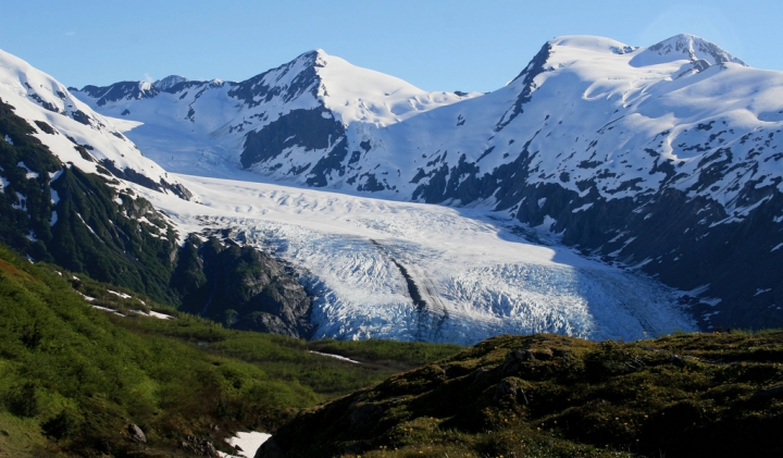 A distant view of Portage Glacier from the Portage Pass trail near Whittier, Alaska.
Credit: Frank Kovalchek, flickr
This is the first time that weve assessed all of the glaciers and been able to say how much of the total is coming from tidewater glaciers, and heres how much of the total is from lake and land glaciers, Shad ONeel, a University of Alaska Fairbanks researcher and co-author of the study, said.
Alaska is an anomaly, with temperatures rising an average of 3 degrees in the last 60 years, twice as fast as the continental U.S.
Scientists predict that temperatures will rise another two to four degrees by 2050. The worlds oceans have already risen 7.5 inches since 1901, and if warming continues unabated, theyre projected to rise as much as 2 feet by the end of the century.
To determine how different types of Alaskan glaciers melt, researchers from the University of Alaska Fairbanks and the U.S. Geological Society relied on a combination of analysis and observations.
RELATED While Most of U.S. Froze, Parts of Alaska Set Record Highs
Alaska Total Ice Loss 2004-07
As Sea Ice Declines, Winter Shifts in Northern Alaska
Airplanes equipped with lasers allowed the scientists to directly measure the mass of more than 100 individual glaciers, representing 40 percent of the ice cover in the Alaska region. The process was repeated every few years to determine how quickly the elevations and masses changed over time.
The researchers combined this data with information from a database to make digital models of the glaciers elevations.
That allowed them to determine how previously unmeasured glaciers lost their mass, something ONeel said had never been done before.
Because accurately measuring individual glaciers is a challenge, previous research used the available data to make a consensus estimate of the worlds glacier loss. Scientists originally thought the Alaska region lost 50 gigatons of mass, or 50 cubic kilometers of water, a year.
This studys researchers found that the number is actually 75 gigatons, which adds 0.008 inches to the sea level each year.
This number may seem small, but from 2005 to 2010, Alaskan glacier losses made up one third of the worlds ice sheet losses, despite having 20 times fewer ice-covered areas than Greenland.
 Alaskas glaciers contributed to one third of the worlds ice sheet losses from 2005 to 2010, but a new study suggests melting, not calving as shown here, contributed to the most loss.
Credit: Mack Lundy/flickr
What we did that is new and gives us more confidence in our results is that we treated every glacier across the whole region independently. Whereas in the past, scientists said, Here are the measurements and we kind of know how much other ice we havent measured, ONeel said.
Everyone just kind of expected Alaska would lose a substantial fraction of mass from calving, he said, referring to the loss of ice from tidewater glaciers. If there was a big piece of the pie that was coming from calving, that would make it harder to predict whats going to happen in the future.
Joseph MacGregor, a University of Texas at Austin glacier researcher who was not involved in the study, said that in undertaking challenging flights over these glaciers the researchers have found a new way to predict how glaciers will thin in the future.
This research points the way toward easier predictions of future glacier thinning, but the future remains bleak for Alaskan glaciers, MacGregor said.
http://www.climatecentral.org/news/a...vel-rise-19159NO AMNESTY
Don't reward the criminal actions of millions of illegal aliens by giving them citizenship.
Sign in and post comments here.
Please support our fight against illegal immigration by joining ALIPAC's email alerts here https://eepurl.com/cktGTn


 Reply With Quote
Similar Threads
-
Second giant ice island set to break off Greenland glacier
By JohnDoe2 in forum Other Topics News and IssuesReplies: 0Last Post: 09-01-2011, 03:04 PM -
Giant Greenland ice island threatens shipping, oil platforms
By JohnDoe2 in forum Other Topics News and IssuesReplies: 1Last Post: 08-10-2010, 07:36 PM -
Giant ice 'island' breaks off Greenland glacier
By JohnDoe2 in forum Other Topics News and IssuesReplies: 0Last Post: 08-06-2010, 07:02 PM -
Man jailed in rapes shaking `safest city'
By jp_48504 in forum illegal immigration News Stories & ReportsReplies: 3Last Post: 09-15-2007, 06:51 PM -
Nanny admits shaking infant
By Brian503a in forum illegal immigration News Stories & ReportsReplies: 3Last Post: 04-04-2006, 12:15 PM


SCOTUS Birthright Citizenship: Suicide of America | Frosty...
07-01-2026, 10:05 PM in General Discussion