

Results 1 to 2 of 2
Thread Information
Users Browsing this Thread
There are currently 1 users browsing this thread. (0 members and 1 guests)
 LinkBack URL
 About LinkBacks
-
04-07-2014, 04:59 PM #1Senior Member


- Join Date
- Aug 2008
- Location
- PARADISE (San Diego)
- Posts
- 99,038
How Politics Buries Science in Landslide Mapping
How Politics Buries Science in Landslide Mapping
BY BILL DEDMAN
NBCNews.com - 20 minutes ago
The six geologists were just starting their work, climbing the mountains of Western North Carolina to map the debris left behind by landslides over millions of years, when the political footing gave way beneath them. Opposition had been building from real estate agents, from home builders planning subdivisions, and then from politicians. When all that energy was released, the science was crushed flat.
The new Republican leadership in the legislature cut off all funding for the state's landslide mapping project in 2011, and the five geologists were laid off. They had mapped just four of 19 counties. Only one geologist kept a state job, but he is not allowed to do any landslide mapping. Another is helping a mining company search for gold. Two are in private practice. The fifth is checking the work of road paving crews. And the sixth moved to Virginia, mapping landslides until the temporary funding for that project ran out.
Against the backdrop of the March 22 mudslide in Washington state, which killed 33 people and left 12 still missing as of Monday, geologists say the story of the team in North Carolina illustrates how America has never put forth a serious effort to learn from the earth's past. Geology experts say science is often a casualty of land politics, as the nation fails to protect others who are unaware they are at risk from deadly landslides.
Signs of an insufficient effort to save lives:
- The federal government hasn't made a national map of areas with landslides hazards in 32 years. That last map was made in 1982 years before computerized mapping tools became commonplace.
- That 1982 map is so poorly defined the official in charge of the federal landslide hazard program calls it a "cartoon" that officials discourage the public from zooming in too closely to look at the map, lest they get bad information.
- The entire federal budget for landslide research is $3.5 million a year far less than the property value lost on a single day when 17 mansions slid down a hill in 2005 in Laguna Beach, Calif. (For comparison, $3.5 million is about the same amount Medicare spends per month buying penis pumps for men with erectile dysfunction.)
- States have been left to pick up the slack, but budgets for landslide mapping have been severely cut in Nevada, Colorado, Georgia, and others, including the politically tinged cuts in North Carolina that cost those five geologists their state jobs.
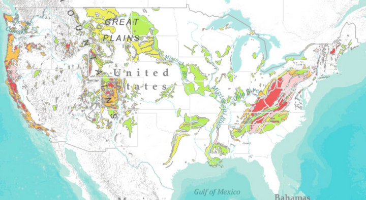 NBC NEWS/ESRI
This 1982 map of landslide hazard areas is the most recent national map, according to the U.S. Geological Survey. The mapping company Esri and NBC News digitized this map, finding that at least 84 million people live within the broad areas identified then as having a moderate or high incidence of or susceptibility to landslides.
Click here to view an enlarged version of the cross-referenced map.
The scientific effort to inform the public about landslide risks often runs head-on into powerful economic interests.
"People come up here from Florida to retire in the mountains, and they look out at the million-dollar views, but people are not looking at the ground under their feet," said former North Carolina state Rep. Ray Rapp, a Democrat who sponsored the landslide mapping and was voted out of office after it was scrapped. The geologists were perceived as threats. If you're selling land that is unstable and liable to slide, what does that do to your sale price?"
What is lacking, scientists say, is not just money, but consensus.
Though the science is solid, geologists say, they aren't sure people want to know the answers. "There are two sides," said Lynn Highland, a geographer and coordinator of the National Landslide Information Center at the USGS office in Denver. Highland says there are "people who think, we need to do this, it's a public safety issue. And then people who say, I have my private property, I have a right to do what I want with it. States and counties are left in a lurch between doing the right thing for public safety, and encouraging growth."
***
History is the best guide to the future. Geologists say that any effort to reduce the risks from landslides must start with an inventory, a detailed map showing where landslides have happened.
Even with good maps, there's no guarantee that the public will get the word about landslide hazards, or that state and local governments will take action to discourage or prevent building in dangerous areas.
Washington is one of the most responsible states at mapping its landslide risks, according to the USGS, and geologists have shown dangers around the Oso area for decades. A 2004 flood-management plan even talked of buying up all the homes in the area to "remove the risk to human life and structures." Instead, the county took action to stabilize the base of an unstable slope a temporary fix overwhelmed by the huge landslide last month.
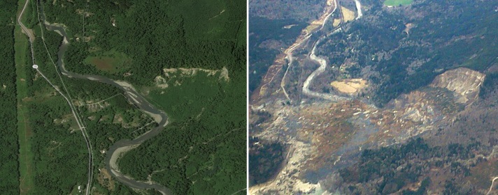
Aerial photos show the community of Oso, Wash., before and after the March 22 landslide.
Debby Rule bought a home on Steelhead Drive in Oso in 2007. She said she and her husband had no idea there was danger above. "We were not informed of a landslide risk," she told NBC News. "We were told about the Hazel Slide in '06, and that the Corps of Engineers had got it fixed. But we had no idea it could reach us. Why did they even authorize people to build homes there?"
Rule and her husband moved away last year, just before he died of cancer. When asked how many of her former neighbors are among the 33 people found so far in the debris, she finds it easier to count the living.
"One ... two ... three. I know of three that are alive out of the eight houses that I knew."
***
The 1982 national landslide risk map was not created to find safe places to build houses. It was made by the U.S. Geological Survey to show areas to avoid when building nuclear power plants and other large engineering works.
"Nuclear power was the driving force," said Highland, the USGS official. But America is hardly building nuclear power plants these days.
That 1982 map made well before the advent of computerized geographical information systems, known as GIS is not detailed enough to show all landslide-prone areas. The mapmakers warned that "individual landslides could not be shown on a map of this scale." And in fact it does not show any hazard in the Oso area, which was well documented in state studies.
"It was never intended as a map to be used for specific areas of the country," said Peter Lyttle, program coordinator for landslide mitigation at USGS headquarters in Reston, Va. "It's a cartoon graphic to show which areas are prone to landslides: the Appalachians, the West Coast, the Mountain West."
While drawing conclusions from such a crude representation is problematic, NBC News and the computer mapping firm Esri plugged in Census data to see how population has changed in the areas identified on the map since it was drawn. Adding together all the landslide-prone areas on the map, Esri found that the total 2000 population living in such zones was 77.2 million. By 2010, the population in those same boundaries had increased by 7 percent to 82.7 million. And by 2013, the population rose another 1.6 percent to 84.0 million or 26 percent of the current U.S. population. Esri's projections show that these areas are expected to add another 3.2 percent by 2018, pushing the population to 86.7 million.
The areas also include about 13 million housing units built after the 1982 map was published, Esri calculated.
***
Congress gave the U.S. Geological Survey a mandate a decade ago to set a national policy to mitigate landslide risks. The USGS estimated that the cost would be $25 million a year, and the National Academy of Sciences offered a higher estimate, $50 million. Instead, Congress allocated only $2.5 million, which has slowly increased to $3.5 million, Lyttle said.
"The plan and the reality are two different things," Highland said. "Congress tells us we need to have a national strategy, but they don't give us the money to do it."
The agency has focused on discrete, modest projects: developing a warning system in areas where major landslides have reduced stabilizing vegetation, setting levels in the Seattle area for warnings after major rainfall that could undermine slopes.
Several states have good landslide maps, Highland said, and she is coordinating a pilot program to get states to cooperate on standards and definitions. Washington, Oregon, and California are among the states with the most complete inventories of landslide hazards, and she named Kentucky, Ohio and West Virginia as other states with particularly good efforts.
Most worrisome, she said, was the North Carolina experience.
***
In September 2004, Western North Carolina was hit by rains from Hurricane Frances, then two weeks later by Hurricane Ivan.
Saturated ground in the mountains crumbled, as the Peek's Creek landslide killed five people and destroyed 15 homes. It cost about $1.3 million to clean up, and $3.2 million to buy out damaged property.
The legislature approved a program to map landslide risks in 19 western counties. State geologist Rick Wooten put a team together, using lidar, the newest technology to help detect changes in the ground with lasers. In one county, the team found more than 2,000 landslides triggered by a storm in the 1940s.
"I know we were making a good scientific product," Wooten said. "We had peer review. We had the right skill set of people working on it."
One member of that team, a young geologist named Jennifer Bauer, went to work making a map in her home county in the mountains. "I grew up in Macon County," she said. "Even growing up here, I was not aware that landslides happen in North Carolina."
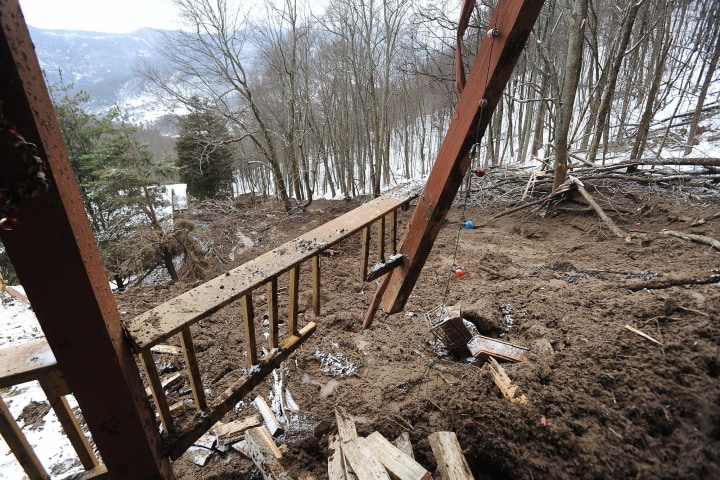 JOHN FLETCHER / ASHEVILLE CITIZEN-TIMES VIA AP, FILE
The landside-damaged home of Kurt Biedler and Tammy Jones in Maggie Valley, N.C. on Feb. 6, 2010. Firefighters had to remove a layer of debris from the basement to free Jones and the family dogs. More than 40 people were evacuated.The work was slow, taking about one year per county, at a cost of about $500,000. In comparison, a landslide in Maggie Valley, N.C., in 2010 cost about $1.4 million to clean up.
"The cost of the mapping to complete an entire county is less than or equivalent to the average home in the county," Bauer said. "If we can save one home from getting destroyed, it pays for the mapping for the entire county."
But the geologists often encountered anxiety as they worked. Real estate agents feared that they would be held responsible legally if they failed to disclose a hazard area to a buyer. Builders were concerned that land values would fall. "A lot of what we were hearing was a lot of misperceptions," Bauer said. "The map didn't say you couldn't build here. It says here's information you can use, where you really need to pay attention."
 RENEE BROOKS / ASLAN CREATIVE
Jennifer Bauer, a member of the North Carolina landslide mapping team that lost its funding in 2011, said the geologists did what they could to calm public fears of regulation. "A lot of what we were hearing was a lot of misperceptions," Bauer said. "The map didn't say you couldn't build here. It says here's information you can use, where you really need to pay attention."In the state capital, the program became a target. The legislator who had proposed the mapping, Ray Rapp, also had proposed legislation to regulate development in areas with a slope of at least 40 percent. Three times the legislature soundly rejected his steep-slope law, which was opposed vigorously by the home builders and Realtors associations.
One influential Republican, state Rep. Mitch Gillespie of Marion, had taped a bull's-eye target on his office window, positioned so dead center was right over the nearby offices of the state Department of Natural Resources. He told reporters that the mapping cuts were part of a general budget reduction, but he added that the mapping was unnecessary and was being done to bolster efforts to reduce development and curtail the rights of landowners.
After Republicans took control of the Legislature in 2011 for the first time since 1870, lawmakers killed the maps and laid off the five geologists. A Republican state senator, Don East, told the Associated Press that the cuts "will get government off the backs of business and industry."
Rep. Rapp was defeated in 2012 after redistricting changed his district to a more Republican population. He said Realtors, who had backed his previous campaigns, also withdrew their support.
Rep. Gillespie, who opposed the mapping, was re-elected, but left the legislature. Now he has an office in the building he once had a bulls-eye on, as assistant secretary for the environment at the Department of Natural Resources. He did not return calls from NBC News.
The North Carolina Association of Realtors also did not respond to requests from NBC News for comment. The association's members had discussed publicly their fears that they might be held accountable for disclosing to property owners landslide risks shown on the map. (California has such a requirement, but most states do not.)
At the North Carolina Home Builders Association, the general counsel and executive vice president, Michael Carpenter, said he didn't believe the group has a policy now on the mapping, which he said is a dead issue in the legislature. "Generally speaking, I'm sure there are areas in which there ought to be protection," he said, but he questioned the science. "How useful is the mapping? How accurate is it? I don't know enough about the science to say."
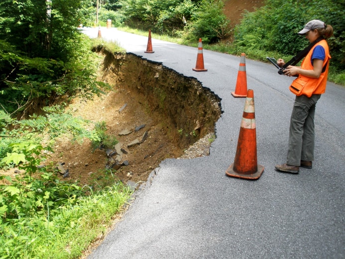 STEPHEN FUEMMELER / APPALACHIAN LANDSLIDE CONSULTANTS
After North Carolina laid off its mapping team in 2011, geologist Jennifer Bauer and geologist Stephen Fuemmeler went into business for themselves, advising landowners on their risks.
"People still want to know this information. The scientists knew what was going on, but the public didn't."Bauer, one of the geologists on the state team, went into business with another team member in Asheville, advising homeowners on their landslide risks. "People still want to know this information," she said. "The scientists knew what was going on, but the public didn't."
Mapping team leader Wooten kept his state job, but he said he got the message that the legislature doesn't want anyone on the payroll mapping landslides.
"We're not a regulatory agency," Wooten said. "We weren't promoting or fighting against regulations on mountainside development. Our job was just to make the maps, so people could make informed decisions about where to build.
"Politically and socially, it's a hard thing to do," Wooten said. "I hope we can get to a point where there will be science education, where people will understand nuance, public education, relative risk. But I'm not sure I'll live long enough."
Donna Mendell of NBC News contributed research for this article.
First published April 7th 2014, 10:00 am
http://www.nbcnews.com/news/investig...mapping-n73256NO AMNESTY
Don't reward the criminal actions of millions of illegal aliens by giving them citizenship.
Sign in and post comments here.
Please support our fight against illegal immigration by joining ALIPAC's email alerts here https://eepurl.com/cktGTn
-
04-08-2014, 12:38 AM #2Senior Member
- Join Date
- Aug 2008
- Location
- PARADISE (San Diego)
- Posts
- 99,038
"How Politics Buries Science"
http://www.alipac.us/f19/koch-brothe...ce1997-290799/NO AMNESTY
Don't reward the criminal actions of millions of illegal aliens by giving them citizenship.
Sign in and post comments here.
Please support our fight against illegal immigration by joining ALIPAC's email alerts here https://eepurl.com/cktGTn


 Reply With Quote

GOP Mayor in Utah Calls African Refugees the American Wests...
07-27-2026, 08:02 AM in General Discussion