

Results 1 to 1 of 1
Thread Information
Users Browsing this Thread
There are currently 1 users browsing this thread. (0 members and 1 guests)
 LinkBack URL
 About LinkBacks
-
12-20-2016, 06:35 PM #1Senior Member


- Join Date
- Aug 2008
- Location
- PARADISE (San Diego)
- Posts
- 99,038
Pre-Christmas melt? North Pole forecast to warm 50 degrees above normal Thursday
Pre-Christmas melt? North Pole forecast to warm 50 degrees above normal Thursday

GFS model simulation of temperature difference from normal Thursday. (WeatherBell.com)
Its not normal, and its happening again.
For the second year in a row in late December and for the second time in as many months, temperatures in the high Arctic will be freakishly high compared to normal.
Computer models project that on Thursday, three days before Christmas, the temperature near the North Pole will be an astronomical 40-50 degrees warmer-than-normal and approaching 32 degrees, the melting point.
View image on Twitter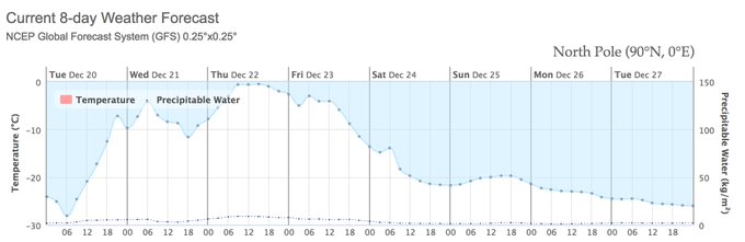
Follow
 Zack Labe
✔@ZLabe
Impressive... model guidance (eg, GFS) indicating surface air temperatures hovering just below freezing at the #NorthPole later this week
7:37 AM - 20 Dec 2016
On some forecast maps simulating Arctic temperatures, the color bar does not even go as high as predicted levels.

GFS model forecast temperature difference (in Celsius) from normal in the Arctic on Thursday. (University of Maine Climate Re-analyzer)
The warmth will be drawn into the Arctic by a powerhouse storm east of Greenland. The European weather model estimates its lowest pressure will be around 945 millibars, which is comparable to many category 3 hurricanes.
Thats pretty intense, said Ryan Maue, a meteorologist with WeatherBell Analytics.

European model forecast low pressure center of 946 millibars east of Greenland Wednesday helping draw mild air into the Arctic through the Nordic sea. (WeatherBell.com)
Maue explained that depleted sea ice cover east of the Nordic Sea helps create a passage way for warm air to surge north uninhibited. You have more real estate available to advect the warm and moist air northward, he said.

Simulation of high altitude temperatures from European model shows mild air from the south streaming through the Nordic sea towards the North Pole. (WeatherBell.com)
Arctic sea ice levels are at a record lows. In November, the Arctic usually gains ice, but over a period of five days it saw 19,000 square miles of ice cover vanish, which NOAA called almost unprecedented.

(National Snow and Ice Data Center)
Zachary Labe, a doctoral student researching the Arctic at the University of California-Irvine, said that the lack of ice in this region has allowed ocean temperatures to warm to levels well above normal.
The warm ocean acts as a buffer to keep the air temperatures from getting colder, Labe said.
Air temperatures in the Arctic above 80 degrees north (latitude) have been much warmer than normal since roughly September.
 (Danish Meteorological Institude adapted by Capital Weather Gang)
The persistence and magnitude of above average Arctic temperatures continues to remain quite impressive Labe said on Twitter.
The month of November was an incredible 18 degrees warmer than normal in the Arctic, the National Snow and Ice Data said.
Richard James, who holds a doctorate in meteorology, found November produced the most anomalously warm Arctic temperatures on record after analyzing data from 19 weather stations. The average temperature was more than 5 degrees warmer than the next warmest November dating back to 1971, he said.
[Abnormally warm Arctic spurs planet to second-warmest November on record]

Temperature difference from normal in Arctic in November. (Climate.gov)
In the middle of the month, the temperature averaged over the entire Arctic north of 80 degrees latitude spiked to 36 degrees above normal.
[The North Pole is an insane 36 degrees warmer than normal as winter descends]
Ted Scambos, a scientist at the National Snow and Ice Data Center, said that he was struck that an area the size of the entire contiguous U.S. had temperatures that far above the norm, all at the same time.
The anomalous warmth to close out 2016 follows a very a similar event at the end of 2015 when Arctic temperatures surged over the melting point.
[From Dec. 2015: Freak storm may push temperatures over 50 degrees above normal at North Pole]
The question the research community is grappling with is whether these huge temperatures spikes are becoming more common.
I dont think anyone can for sure say, said Labe. The variability in the Arctic is tremendous. It usually does bring in brief periods of very warm weather [compared to normal].
WeatherBells Maue agreed saying the big Arctic storms which have drawn mild air into the Arctic both this year and last year are part and parcel of Atlantic weather variability.
A study published in the journal Nature on Dec. 15 said these events have happened once or twice a decade going to back to the 1950s.
While its premature to say if these events are becoming more frequent, the intensity of the warm air reaching the Arctic is almost certainly increasing.
[T]he warmest midwinter temperatures at the North Pole have been increasing at a rate that is twice as large as that for mean midwinter temperatures at the pole, the Nature study said. It is argued that this enhanced trend is consistent with the loss of winter sea ice from the Nordic Seas that moves the reservoir of warm air over this region northwards making it easier for weather systems to transport this heat polewards.
When these excessive warm anomalies occur in the Arctic, the cold air which is usually present must go somewhere. In November, it piled up in Siberia and that is poised to happen again:


Follow
 Ryan Maue
✔@RyanMaue
Whoa Vlad! That's some cold air in central Russia. -60s °F
11:04 AM - 20 Dec 2016
And eventually some of the cold air in Siberia crossed the pole and dived into North America in mid-December. Only time will tell if history is to repeat itself.
Jason is the Washington Posts weather editor and Capital Weather Gang's chief meteorologist. He earned a master's degree in atmospheric science, and spent 10 years as a climate change science analyst for the U.S. government. He holds the Digital Seal of Approval from the National Weather Association.
Follow @capitalweatherNO AMNESTY
Don't reward the criminal actions of millions of illegal aliens by giving them citizenship.
Sign in and post comments here.
Please support our fight against illegal immigration by joining ALIPAC's email alerts here https://eepurl.com/cktGTn


 Reply With Quote
Similar Threads
-
The North Pole is an insane 36 degrees warmer than normal as winter descends
By JohnDoe2 in forum Other Topics News and IssuesReplies: 1Last Post: 11-24-2016, 03:07 PM -
Freak storm pushes North Pole 50 degrees above normal to melting point
By JohnDoe2 in forum Other Topics News and IssuesReplies: 3Last Post: 12-31-2015, 12:37 AM -
Weekend temperatures in Southern California could be 20 degrees above normal
By JohnDoe2 in forum Other Topics News and IssuesReplies: 1Last Post: 03-13-2015, 01:05 PM -
How Much Will the South Pole Melt ?
By JohnDoe2 in forum Other Topics News and IssuesReplies: 0Last Post: 08-25-2014, 04:02 PM -
At 104 degrees, the forecast is death
By Jean in forum illegal immigration News Stories & ReportsReplies: 3Last Post: 03-18-2007, 10:55 PM


Biden Judge Blocks Trump Admin Termination of Temporary...
05-01-2026, 04:27 PM in illegal immigration News Stories & Reports