

Results 1 to 9 of 9
 8Likes
Thread Information
Users Browsing this Thread
There are currently 1 users browsing this thread. (0 members and 1 guests)
 LinkBack URL
 About LinkBacks
-
09-03-2018, 02:30 PM #1Senior Member


- Join Date
- Aug 2018
- Posts
- 62,861
Tropical Storm Gordon Moving Into Gulf of Mexico as it Soaks South Florida; Hurricane
Tropical Storm Gordon Moving Into Gulf of Mexico as it Soaks South Florida; Hurricane Watch and Tropical Storm Warnings Posted
By the weather.com digital meteorologists
less than an hour ago
weather.com
Video at the page link
01:16
Dangerous Storm Surge Threat from Tropical Storm Gordon Along Gulf Coast
A real danger from Tropical Storm Gordon along the northern Gulf Coast will be storm surge.
At a Glance
- Tropical Storm Gordon is now moving into the Gulf of Mexico.
- Soaking rainfall and gusty winds from Gordon are currently spreading across southern Florida.
- Tropical storm warnings are posted for South Florida and the northern Gulf Coast.
- A hurricane watch is now in effect for the Alabama and Mississippi coasts.
- Heavy rain, storm-surge flooding and strong winds are possible impacts from Gordon on the Gulf Coast.
- Storm surge warnings and watches are also in effect for a part of the northern Gulf Coast.
Tropical Storm Gordon is pushing into the Gulf of Mexico as it continues to bring heavy rain and gusty winds to Florida. Gordon will head for a northern Gulf Coast landfall late Tuesday as a strong tropical storm or possibly a Category 1 hurricane.
The National Hurricane Center has now issued a hurricane watch from the mouth of the Pearl River, Mississippi, to the border between Alabama and Florida.
A hurricane watch means hurricane-force winds (74-plus mph) are possible in the area indicated beginning late Tuesday or Tuesday night.
Tropical storm warnings are posted for South Florida, from Golden Beach on the southeastern coast to Bonita Beach on the southwestern coast, as well as for the Keys, from Craig Key to Ocean Reef.
Tropical storm warnings are also posted from the Okaloosa-Walton County border in Florida westward to east of Morgan City, Louisiana, including Lake Pontchartrain and Lake Maurepas.
A tropical storm warning is typically issued when tropical-storm-force winds (39-plus mph) are expected in 36 hours or less.
Residents along the northern Gulf Coast should continue to make preparations for Gordon through Tuesday morning.

Watches and Warnings
(A tropical storm watch means tropical storm conditions are possible within 48 hours. A warning means those conditions are expected within 36 hours.)
(MORE: Hurricane Central)
Current Status and Forecast
Gordon is currently centered about 15 miles west-southwest of Marco Island, Florida, and is producing numerous showers and thunderstorms in southern Florida.

Current Storm Status
(The highest cloud tops, corresponding to the most vigorous convection, are shown in the brightest red colors. Clustering, deep convection around the center is a sign of a healthy tropical cyclone.)
Localized flooding is possible, and the National Weather Service has issued a flood watch for South Florida into Monday night.
In addition, tropical-storm-force winds (39 mph or greater) are possible in the tropical storm warning area in southern Florida on Monday. A wind gust to 51 mph was reported at Miami's Opa Locka Executive Airport on Monday morning.
An isolated tornado threat cannot be ruled out through Monday night across the southern and west-central Florida Peninsula, as well.
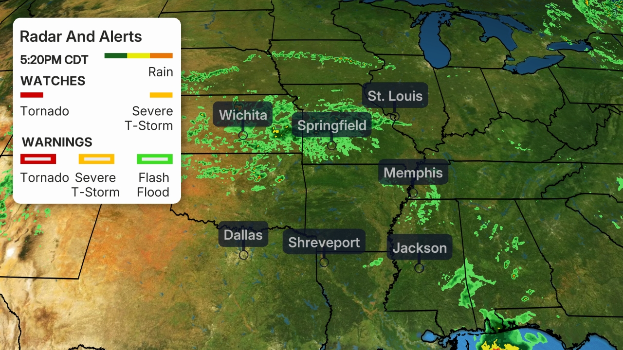
Current Radar, Watches and Warnings
(Watches and warnings are issued by the National Weather Service.)
Conditions should begin to improve Monday night in South Florida.
Steered by high pressure aloft parked over the eastern United States, Gordon will move through the eastern Gulf of Mexico Monday night through Tuesday.
Gordon is forecast to be a strong tropical storm near the time it makes landfall on the northern Gulf Coast Tuesday night, most likely in southeastern Louisiana, southern Mississippi or southern Alabama. There is some chance Gordon could attain Category 1 hurricane strength just before landfall, and that's why the NHC issued a hurricane watch for parts of the Mississippi and Alabama coasts.

Projected Path
(The red-shaded area denotes the forecast path of the center of Gordon. Note that impacts (particularly heavy rain, high surf, coastal flooding) from Gordon may spread beyond its forecast path.)
Northern Gulf Coast Impacts
Here's a look at the current forecast impacts for Gordon, but keep in mind, changes are possible based on future adjustments to track and intensity.
Rainfall
Parts of the northern Gulf Coast could see 4 to 6 inches of rainfall Tuesday through Wednesday, from southeastern Louisiana into far southern Mississippi and far southern Alabama. Localized totals of 8 inches or more are possible in some areas by early Thursday.
As a result, there could be flooding in this region, including the New Orleans and Mobile, Alabama, metro areas. A flash flood watch has been posted by the National Weather Service for parts of southeastern Louisiana, southern Mississippi and coastal Alabama.
Separate flash flood watches are in effect in southeastern Texas and southwestern Louisiana due to heavy rain from another weather system affecting that region on Monday.

Rainfall Outlook
(This should be interpreted as a broad outlook of where the heaviest rain may fall. Higher amounts may occur where bands or clusters of thunderstorms stall for over a period of a few hours.)
Storm Surge, Rip Currents and High Surf
A storm surge warning has been issued from Shell Beach, Louisiana, to Mississippi-Alabama border. This means within 36 hours, parts of this coastline could see a dangerous, life-threatening storm-surge inundation.
There is a storm surge watch posted from west of Shell Beach, Louisiana, to the mouth of the Mississippi River and from the border between Mississippi and Alabama to Navarre, Florida.

Storm Surge Watches and Warnings
The NHC said water could reach the following heights above ground somewhere in the indicated areas if the peak surge occurs at the time of high tide:
- Shell Beach, Louisiana, to the Mississippi-Alabama border: 3 to 5 feet
- Navarre, Florida, to the Mississippi-Alabama border: 2 to 4 feet
- Shell Beach, Louisiana, to the mouth of Mississippi River: 2 to 4 feet
- Mouth of the Mississippi River to the Louisiana-Texas border: 1 to 2 feet
Storm-Surge Inundation Forecast
(Values indicated are water levels above ground if the peak surge coincides with the time of high tide.)
High tide this week on the Louisiana and Mississippi coastline is in the early-morning hours. Tuesday morning through Thursday evening is the timing for potential coastal flooding in the storm surge watch area, according to the National Weather Service.
The deepest water will occur along the immediate coast near and to the east of the landfall location, where the surge will be accompanied by large waves, according to the NHC.
An onshore wind flow will continue a risk of dangerous rip currents on the northern Gulf Coast into midweek, and swimmers are encouraged to stay out of the water.
Seas are expected to build to 6 to 10 feet by Tuesday, according to the National Weather Service in Mobile, Alabama.
Wind
Tropical-storm-force winds (39-plus mph) are possible in the tropical storm warning area in South Florida on Monday.
By late Tuesday, tropical-storm-force winds could arrive on the northern Gulf Coast in the tropical storm warning area. Hurricane-force winds are possible in the hurricane watch area late Tuesday or Tuesday night.
Downed trees and power outages are expected where the tropical storm warning and hurricane watch are posted along the northern Gulf Coast. This is expected no matter whether Gordon is a strong tropical storm or a Category 1 hurricane at landfall.

Tropical-Storm-Force Wind Probabilities
(The contours above show the chance of tropical-storm-force winds (at least 39 mph), according to the latest forecast by the National Hurricane Center.)
Check back with weather.com for the latest as we track Gordon in the Gulf of Mexico this week.
https://weather.com/storms/hurricane...ida-gulf-coastLast edited by Airbornesapper07; 09-03-2018 at 02:38 PM.
-
09-03-2018, 02:31 PM #2Senior Member
- Join Date
- Aug 2018
- Posts
- 62,861
-
09-03-2018, 02:32 PM #3Super Moderator


- Join Date
- Aug 2006
- Posts
- 21,880
Praying for safety and a change in the weather.
Matthew 19:26
But Jesus beheld them, and said unto them, With men this is impossible; but with God all things are possible.
____________________
Join our efforts to Secure America's Borders and End Illegal Immigration by Joining ALIPAC's E-Mail Alerts network (CLICK HERE)
-
09-03-2018, 02:44 PM #4Moderator

- Join Date
- Apr 2016
- Posts
- 31,073
No more storm damage...we have had our share!
Give us a break already ILLEGAL ALIENS HAVE "BROKEN" OUR IMMIGRATION SYSTEM
DO NOT REWARD THEM - DEPORT THEM ALL
-
09-03-2018, 03:02 PM #5Senior Member
- Join Date
- Aug 2018
- Posts
- 62,861
we took at Direct hit almost exactly 1 year ago from Hurricane Irma Cat 4 here in Naples; Even seen the blue skys over head as the eye passed almost centered on my house it seems. I am still cleaning up 200+ trees that went down on my property and here I am looking outside the rain is almost a white out at times.... 9 inches of rain so far and everything is soaked
-
09-03-2018, 03:31 PM #6Moderator
- Join Date
- Apr 2016
- Posts
- 31,073
We have had rain all Spring and Summer, flooded basement and garage
Problems all across the country and many displaced people by floods, hurricanes, fires, mudslides and volcanos.
Plus we are taking in thousands from Puerto Rico. We need to get our people in jobs and homes!
We do NOT need to bring any more people to this country from around the World! We need to take care of our own now.
10 YEAR MORATORIUM ON ALL IMMIGRATION
GET THE INFRASTRUCTURE REBUILT AND CUT OFF ALL FOREIGN AID!ILLEGAL ALIENS HAVE "BROKEN" OUR IMMIGRATION SYSTEM
DO NOT REWARD THEM - DEPORT THEM ALL
-
09-03-2018, 05:02 PM #7Senior Member
- Join Date
- Aug 2018
- Posts
- 62,861
Tropical Cyclone Threatens South Florida, Takes Aim At Gulf Coast

As Gordon pushes into the Gulf of Mexico this week, it will interact with anomalously warm waters as it churns toward the Gulf Coast...
Mon, 09/03/2018 - 16:25
Multiple tweets with videos at the page link
Tropical Storm Gordon formed over the Florida Keys Monday morning and is poised to bring very heavy rainfall to south Florida on this Labor Day. As Gordon pushes into the Gulf of Mexico this week, it will interact with anomalously warm waters as it churns toward the Gulf Coast.

All things considered, the track of Gordon is fairly high confidence, tracking toward the central Gulf Coast this week. Folks from eastern TX to FL should have a plan in place, regardless of intensity (Source/ @EdValleeWx)
While Gordon will have limited time to rapidly strengthen and will have less than ideal conditions to do so, it still warrants attention for its impacts. Heavy rains, minor storm surge, and gusty winds are all but certain as this system approaches the central Gulf Coast Tuesday afternoon and Tuesday night, regardless of classification.

European EPS illustrating the flooding risk with Gordon and the stalled frontal boundary nearby. 80-90 percent chance of 5″+ rain next 10 days (Source/ @EdValleeWx)
Because of these risks, tropical storm warnings and hurricane watches have been issued for portions of the central Gulf Coast as of midday Monday. Upon landfall, this system may track northeastward into the ag belt, prompting more heavy rains in portions of the Midwest and Ohio Valley late this week into next weekend, said meteorologist Ed Vallee of Vallee Weather Consulting.
Currently, Tropical Storm Gordon is advancing into the Gulf of Mexico as it continues to bring heavy rain and gusty winds to South Florida. The tropical cyclone is moving west-northwest at 16 miles per hour with sustained winds around 45 miles per hour. The Weather Channel reports that Gordon will head for the northern Gulf Coast landfall on Tuesday as a possible Category 1 hurricane.
Potential Tropical Cyclone Excessive Rainfall Outlook For South Florida

Trajectory: Tropical Storm Gordon Heads Northwest

Global + Hurricane Models for Gordon

The National Hurricane Center (NHC) has now declared a hurricane watch from the Mouth of the Pearl River, Mississippi, to the border between Alabama and Florida. The NHC warns that a hurricane watch could mean hurricane-force winds (+74 miles per hour) for New Orleans to Mobile, Alabama, beginning late Tuesday or Tuesday night.Tropical storm warnings are posted for South Florida, from Golden Beach on the southeast coast to Bonita Beach on the southwest coast as well as the Keys from Craig Key to Ocean Reef. Tropical storm warnings are also posted from the Okaloosa-Walton County border in Florida westward to east of Morgan City, Louisiana, including Lake Pontchartrain and Lake Maurepas, stated the Weather Channel.
US Active Weather Alerts Map

Some regions of the northern Gulf Coast could see 3 to 6 inches rainfall Tuesday-Wednesday, especially southeast Louisiana into south Mississippi and Alabama.
As a result, there could be severe flooding in New Orleans and Mobile, Alabama, metro areas. The NHC has posted a flash flood watch for parts of southeast Louisiana, southern Mississippi, and coastal Alabama.
Rainfall Forcast Through Thursday

The NHC warned that water heights above ground during high tide could pose a serious threat to communities based on the water:
- Shell Beach, Louisiana, to the Mississippi-Alabama border: 3 to 5 feet
- Navarre, Florida, to the Mississippi-Alabama border: 2 to 4 feet
- Shell Beach, Louisiana, to the Mouth of Mississippi River: 2 to 4 feet
- Mouth of the Mississippi River to the Louisiana-Texas border: 1 to 2 feet
Gulf Coast Flooding Concerns

As of Monday, tropical-storm-force winds (+39 miles per hour) are possible in the tropical storm warning area in South Florida. By late Tuesday, possible hurricane-force winds could arrive on the northern Gulf Coast. In the tropical storm warning map below, there is a high risk of downed trees and power outages for mainly the Mississippi Gulf Coast.
Force Wind Probabilities For Gulf Coast

How is social media reacting to the potential threats of Tropical Storm Gordon?
Palm Beach reporter tweets, Strong rain band hitting Palm Beach from Tropical Storm Gordon
A Twitter user in Boynton Beach shows a short video of heavy rain and strong winds
CBS12 reporter films heavy rain dumping onto the i-95
Surfers are taking advantage of waves at Haulover Beach
Viewing Gordon from a Miami highrise
Intense winds
Live Stream from Bayfront, Park, Florida
The NHC has just issued another alert this week for yet another storm brewing over the eastern Atlantic Ocean. Stay tuned for more developments.

https://www.zerohedge.com/news/2018-...aim-gulf-coast
-
09-03-2018, 05:26 PM #8Super Moderator
- Join Date
- Aug 2006
- Posts
- 21,880
Head’s Up: TS Gordon – Coastal FL Panhandle, Alabama, Mississippi, Louisiana…
September 3, 2018 by sundance
Tropical Storm Gordon is anticipated to move into the warm Gulf of Mexico this afternoon and then strengthen while taking a West-northwest path toward the Alabama, Mississippi and Louisiana coast. High probability will make landfall as a hurricane.
This storm will move fast while simultaneously strengthening. Residents in coastal west-FL Panhandle, Alabama, Mississippi and Louisiana would be well advised to be proactive, watch closely and begin initial hurricane preparation.

[Hurricane Advisory] At 200 PM EDT (1800 UTC), the center of Tropical Storm Gordon was located near latitude 25.8 North, longitude 81.9 West. Gordon is moving toward the west-northwest near 16 mph (26 km/h) and a west-northwestward to northwestward motion is expected over the next 72 hours. On the forecast track, the center of Gordon will move farther away from the southwestern coast of Florida this afternoon and move across the eastern Gulf of Mexico tonight and Tuesday.
The center of Gordon will approach the coast within the warning area along the central Gulf Coast by late Tuesday or Tuesday night, and move inland over the lower Mississippi Valley on Wednesday.
Maximum sustained winds have increased to near 50 mph (85 km/h) with higher gusts. Additional strengthening is forecast during the next 36 hours, and Gordon is expected to be near hurricane strength when it makes landfall along the central Gulf Coast.
Tropical-storm-force winds extend outward up to 45 miles (75 km) from the center. [Link to NOAA Hurricane Center]


https://theconservativetreehouse.com...ppi-louisiana/Matthew 19:26
But Jesus beheld them, and said unto them, With men this is impossible; but with God all things are possible.
____________________
Join our efforts to Secure America's Borders and End Illegal Immigration by Joining ALIPAC's E-Mail Alerts network (CLICK HERE)
-
09-03-2018, 09:47 PM #9Senior Member
- Join Date
- Aug 2018
- Posts
- 62,861


 Reply With Quote


Similar Threads
-
Tropical Storm Nate threatens to hit U.S. Gulf Coast
By Judy in forum Other Topics News and IssuesReplies: 1Last Post: 10-06-2017, 07:26 AM -
FEMA Urges Gulf Coast Residents to Prepare for Tropical Storm Karen
By JohnDoe2 in forum Other Topics News and IssuesReplies: 1Last Post: 10-04-2013, 08:56 PM -
Tropical Storm Karen headed for U.S. Gulf Coast
By JohnDoe2 in forum Other Topics News and IssuesReplies: 0Last Post: 10-03-2013, 02:53 PM -
Hurricane Ida Moving Into The Gulf - Radar Loop
By AirborneSapper7 in forum Other Topics News and IssuesReplies: 3Last Post: 11-09-2009, 11:00 PM


Congressman Eli Crane says Biden administration is stonewalling...
04-24-2024, 05:07 AM in illegal immigration News Stories & Reports