

Results 81 to 90 of 104
Thread Information
Users Browsing this Thread
There are currently 1 users browsing this thread. (0 members and 1 guests)
 LinkBack URL
 About LinkBacks
-
06-18-2026, 03:45 PM #81Super Moderator


- Join Date
- Feb 2024
- Posts
- 3,865
$750 Million Data Center IS DRYING Georgia - Shocking 500,000 Gallons GONE EVERY DAY
Credits:
Channel: Crisis Radar
Published: 6/18/26
10:05 minutes
-
06-20-2026, 11:58 AM #82Super Moderator
- Join Date
- Feb 2024
- Posts
- 3,865
NWS confirms EF3 tornado in Effingham County, seven tornadoes confirmed across central Illinois
https://watchers.news/2026/06/20/nws...tral-illinois/
ByRishav Kothari
Saturday, June 20, 2026
12:52 UTC
Follow us on Google News
The National Weather Service (NWS) Central Illinois office confirmed seven tornadoes across central Illinois following severe thunderstorms on June 17, 2026, including an EF3 tornado with peak winds of 241 km/h (150 mph) that tracked 42.2 km (26.2 miles) through Effingham County and injured two people. The surveys documented tornadoes affecting portions of Effingham, Jasper, Coles, Menard, Sangamon, Christian, Macon, Shelby, and Moultrie counties.

The Effingham County tornado was the strongest and most destructive of the outbreak. It touched down near Beecher City at 06:26 and remained on the ground until 06:58, reaching a maximum width of 457 m (1 500 feet).
Survey teams assigned the tornado an EF3 rating and estimated peak winds of 241 km/h (150 mph). Two injuries were reported associated to the twister.
The tornado initially produced EF0 and EF1 damage along Illinois Route 33 near Beecher City, snapping and uprooting large trees and damaging grain silos and farm outbuildings.
As it moved east through Shumway, it intensified to EF2 strength, snapping hardwood and softwood trees roughly two-thirds of the way up their trunks, removing the roof from a single-family residence, and destroying multiple farm buildings.
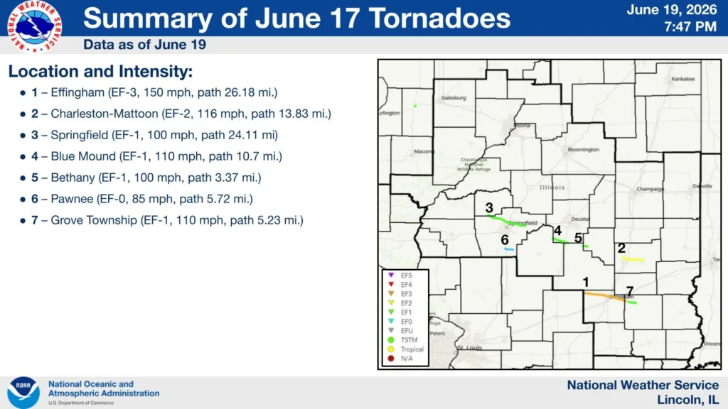 Image credit: NWS Central IllinoisThe most severe damage occurred north of Effingham along East 1800th Avenue, where NWS investigators found EF3 damage, including the destruction of a single-family home that suffered complete exterior wall collapse.
Additional EF3 damage occurred at nearby farmsteads, where large outbuildings were demolished and homes sustained complete roof loss and structural failure. After crossing U.S. Highway 45 in Effingham, the tornado destroyed a large metal building following failure of an X-brace system and threw a delivery van approximately 137 m (450 feet).
The tornado continued southeast across Interstate 70 and into the Teutopolis area, where it caused major tree damage and complete roof loss at several homes.
Near the intersection of Highway 40 and North 1950th Street, survey teams documented the destruction of large barns and outbuildings and the complete removal of a residence roof.
The tornado maintained EF3 intensity into rural Teutopolis, where peak winds were estimated at 225 km/h (140 mph) near North 2100th Street and East 1500th Avenue. Two homes were destroyed before the tornado crossed into Jasper County, weakened to EF2 intensity, and eventually lifted north of Island Grove.

The second strongest tornado developed about 6 km (4 miles) north of Mattoon and tracked southeast toward Charleston. Rated EF2, the tornado reached estimated peak winds of 187 km/h (116 mph), remained on the ground for 22 km (14 miles), and reached a maximum width of 732 m (800 yards). One injury occurred when a semi-truck was overturned on Interstate 57.
Survey teams documented damage to homes, farm buildings, electrical transmission lines and trees before the tornado crossed through the north side of Charleston, damaging the fairgrounds, outbuildings, and additional trees before lifting east of the city along Illinois Route 16.
Five additional tornadoes were confirmed elsewhere in central Illinois. An EF1 tornado tracked 39 km (24 miles) from southern Menard County into Sangamon County, first touching down near Salisbury.
In addition to extensive tree damage, it damaged a garage and the roof of a nearby home before continuing through northern Springfield, where it damaged more trees and blew in the garage door of a business. Portions of the path followed the same track as an EF1 tornado that struck the area on June 10 before dissipating west of Mechanicsburg.

Another EF1 tornado developed in the Griswold Conservation Area in northern Christian County and crossed into Macon County near Blue Mound. The tornado caused extensive tree damage, damaged structures in town, tore part of the roof from Meridian Elementary School, destroyed two grain bins south of the school, and downed electrical transmission lines.
It continued across U.S. Route 51 and into Shelby County, causing additional damage to trees and transmission infrastructure before lifting northeast of Moweaqua. Survey teams estimated peak winds of 177 km/h (110 mph), a path length of 17 km (11 miles), and a maximum width of 640 m (2 100 feet).
NWS also documented an EF1 tornado southwest of Bethany with peak winds of 161 km/h (100 mph) and a 5.5 km (3.4 mile) path. The tornado snapped softwood trees, removed large branches from hardwood trees, crossed from Christian County into Moultrie County, and lifted south of Bethany.

A separate EF1 tornado formed in Grove Township in Jasper County after the Effingham tornado underwent a cycling process. The tornado caused major roof damage to a two-story house, rolled an SUV, damaged an outbuilding, and snapped several large hardwood trees near North 300th Street.
Additional damage occurred along East 1700th Avenue, where homes, mobile homes, trees, and agricultural structures sustained impacts before the tornado lifted east of North 800th Street. The tornado had estimated peak winds of 177 km/h (110 mph), a path length of 8.4 km (5.2 miles), and a maximum width of 160 m (175 yards).
The final tornado surveyed by NWS was an EF0 that touched down west of Pawnee Junction near the Interstate 55 exit and tracked east through Comanche Village and Pawnee before dissipating southeast of town.
The tornado primarily caused tree damage along its 9.2 km (5.7-mile) path, although minor roof and soffit damage was also reported. Estimated peak winds reached 137 km/h (85 mph), and no injuries occurred.
References:
1 June 17, 2026 Severe Weather – NWS – June 19, 2026
Featured image credit: representational image of Spiritwood/Urbana EF3 tornado on June 20, 2025. Credit: Tanner Charles, NWS
Author profile
Articles

Rishav Kothari
I am an Assistant Editor and Severe Weather & Science Journalist at The Watchers, specializing in real-time severe weather coverage, geophysical event reporting, and research-driven scientific analysis. You can reach me at rishav(at)watchers(.)news.
Last edited by GaiaGoddess; 06-20-2026 at 12:02 PM.
-
06-21-2026, 02:13 PM #83Super Moderator
- Join Date
- Feb 2024
- Posts
- 3,865
Cascadia CRACKS OPEN —115,000 Americans On Subduction DEATH ZONE Alert
Credits:
Channel: Crisis Radar
Published: 6/21/26
11:35 minutes
-
06-22-2026, 07:29 PM #84Super Moderator
- Join Date
- Feb 2024
- Posts
- 3,865
Lake Powell GOES DARK - Glen Canyon Dam Cuts Power To 5 Million Americans
Credits:
Channel: Crisis Radar
Published: 6/22/26
11:15 minutes
-
06-24-2026, 12:27 PM #85Super Moderator
- Join Date
- Feb 2024
- Posts
- 3,865
Salton Sea Lake CAVES IN - Toxic Lakebed DAMAGES 40% Of Kids Lungs In 11Km Radius
Credits:
Channel: Crisis Radar
Published: 6/24/26
12:30 minutes
-
06-24-2026, 01:14 PM #86Super Moderator
- Join Date
- Feb 2024
- Posts
- 3,865
Shocking Images Of ROOFS FLYING In Russia's EXTREME Tornado Disaster - $1 Billion In DAMAGES
Credits:
Channel: Crisis Radar
Published: 6/24/26
9:56 minutes
-
06-25-2026, 12:46 PM #87Super Moderator
- Join Date
- Feb 2024
- Posts
- 3,865
Shocking Images Of Venezuela DEADLY 7.5 Earthquake - $3.2 Billion In DAMAGES, 160+ Deaths
Credits:
Channel: Crisis Radar
Published: 6/25/26
13:15 minutes
-
06-26-2026, 02:36 PM #88Super Moderator
- Join Date
- Feb 2024
- Posts
- 3,865
Mount Rainier ALERT! Mountain CRACKS from 1350+ EARTHQUAKES - 40 Minute DEATH COUNTDOWN BEGINS?!
Credits:
Channel: Crisis Radar
Published: 6/26/26
22:17 minutes
Last edited by GaiaGoddess; 06-26-2026 at 02:40 PM.
-
06-27-2026, 08:38 PM #89Super Moderator
- Join Date
- Feb 2024
- Posts
- 3,865
Extreme Heat Watches and Heat Advisories issued across Illinois, Missouri, Kansas, Iowa, Nebraska, and South Dakota
https://watchers.news/2026/06/27/ext...-south-dakota/
ByRishav Kothari
Saturday, June 27, 2026 13:30 UTC
Heat Advisories and Extreme Heat Watches have been issued across parts of Illinois, Missouri, Kansas, Iowa, Nebraska and South Dakota ahead of intensifying heatwave beginning Sunday, June 28, 2026. Heat index values are forecast to exceed 38°C (100°F) across much of the region, with some areas expected to reach 41 to 43°C (105 to 110°F) through Tuesday or Thursday, depending on location.
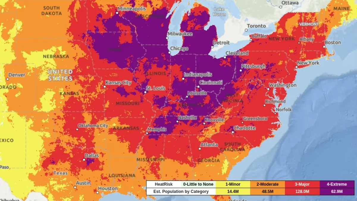
Heat Index for July 2, 2026. Credit: NWS/WPC
A widespread period of dangerous heat is expected to affect large portions of the central United States through next week into the July 4 weekend.
National Weather Service offices across the country have issued Heat Advisories and Extreme Heat Watches covering parts of Kansas, Missouri, Illinois, Iowa, Nebraska, and South Dakota.
Heat indices of over 38°C (100°F) across many locations, while several areas could experience peak values between 41 and 43°C (105 and 110°F).
Kansas
Heat Advisories are in effect from 13:00 CDT Sunday, June 28, until 21:00 CDT Wednesday, July 1, across central, east-central, south-central, and southeast Kansas, where heat index values of 38 to 41°C (100 to 105°F) are forecast.
An Extreme Heat Watch covers north-central, northeast, and east-central Kansas from Sunday afternoon through Tuesday evening, June 30, with peak heat index values potentially reaching 42°C (108°F). Eastern Kansas, including areas near the Missouri border, is also included in a broader Extreme Heat Watch covering adjacent portions of Missouri through Tuesday evening.
Illinois and Missouri
Heat Advisories cover broad areas of southern, central, and western Illinois together with central, eastern, northeastern, southeastern, and western Missouri from Sunday afternoon through Thursday night, where daily heat index values above 38°C (100°F) are expected. These advisories will be effective between 12:00 and 13:00 CDT on Sunday, June 28, and remain in effect until either 20:00 CDT or 00:00 CDT Friday, July 3, depending on the forecast area.
Meanwhile, an Extreme Heat Watch is in effect for the St. Louis metropolitan region—including Madison, Monroe, and St. Clair counties in Illinois and Jefferson, St. Charles, St. Louis County, and St. Louis City in Missouri—from Sunday afternoon, June 28, through Thursday evening, July 2, where heat index values of 41 to 43°C (105 to 110°F) are possible. Additional Extreme Heat Watches cover northeast Missouri and portions of western Illinois from Sunday afternoon through Tuesday evening, June 30.
Iowa
Heat Advisories begin at 13:00 CDT Sunday, June 28, across northwest, west-central, and southwest Iowa. Depending on location, the advisories remain in effect until either 21:00 CDT Monday, June 29, or 21:00 CDT Tuesday, June 30, with forecast heat index values generally ranging from 39 to 41°C (103 to 105°F).
Much of Iowa is also under an Extreme Heat Watch from Sunday afternoon through Tuesday evening, June 30, while southwest Iowa is included in a separate watch for the Omaha metropolitan area, where heat index values may approach 42°C (108°F).
Nebraska and South Dakota
Heat Advisories will start going into effect at 13:00 CDT Sunday, June 28, across Nebraska. Advisories for eastern and southeastern Nebraska remain in effect until 21:00 CDT Tuesday, June 30, while Cedar and Knox counties in northeast Nebraska are under a shorter-duration advisory until 21:00 CDT Sunday.
In southeast South Dakota, most advisories remain in effect from 13:00 CDT Sunday until 21:00 CDT Monday, although Bon Homme, Hanson, Hutchinson, and McCook counties are under a one-day advisory ending at 21:00 CDT Sunday.
Heat index values are expected to reach 39 to 41°C (103 to 105°F). Douglas and Sarpy counties in Nebraska, together with adjacent counties in southwest Iowa, are also under an Extreme Heat Watch from Sunday afternoon through Tuesday evening, June 30, where heat index values may reach 42°C (108°F).
The National Weather Service warns that prolonged exposure to these conditions can significantly increase the risk of heat-related illnesses, particularly during the afternoon and early evening when apparent temperatures are highest. Several forecast areas are also expected to experience unusually warm overnight conditions that will limit overnight cooling and increase cumulative heat stress over successive days.
Residents across affected areas are urged to remain hydrated, limit strenuous outdoor activity during the hottest part of the day, seek air-conditioned environments whenever possible, and continue monitoring official forecasts for additional advisories, watches, or warnings.
References:
1 Extreme Heat Watch – NWS – June 27, 2026
2 Heat Advisory – NWS – June 27, 2026
Author profile
Articles
Rishav Kothari
I am an Assistant Editor and Severe Weather & Science Journalist at The Watchers, specializing in real-time severe weather coverage, geophysical event reporting, and research-driven scientific analysis. You can reach me at rishav(at)watchers(.)news.
Last edited by GaiaGoddess; 06-27-2026 at 08:41 PM.
-
06-28-2026, 09:34 PM #90Super Moderator
- Join Date
- Feb 2024
- Posts
- 3,865
They control the WEATHER!!
https://www.youtube.com/shorts/oY6wh_SgKk8
Credits:
Channel: RFB II
Published: 6/28/26
1 minute


 Reply With Quote
Similar Threads
-
The dying of the West: Lake Mead and Lake Powell may not refill “in our lifetimes” wa
By Airbornesapper07 in forum Other Topics News and IssuesReplies: 1Last Post: 02-08-2023, 08:32 AM -
Hoover Dam, Lake Mead officers getting 52,000 rounds of ammo
By JohnDoe2 in forum Other Topics News and IssuesReplies: 1Last Post: 07-13-2015, 11:18 AM -
Boats roll on Strip to protest Lake Mead closure .... and so it begins
By AirborneSapper7 in forum General DiscussionReplies: 2Last Post: 10-08-2013, 03:01 PM -
Drought has Lake Mead at historic low
By JohnDoe2 in forum Other Topics News and IssuesReplies: 0Last Post: 11-01-2010, 01:36 PM -
Lake Mead sinks to a new historic low: Ariz. could experienc
By AirborneSapper7 in forum Other Topics News and IssuesReplies: 1Last Post: 10-20-2010, 03:37 AM


House Joint Resolution to Abolish the Seventeenth Amendment...
07-22-2026, 02:24 AM in Non-Citizen & illegal migrant voters