

Results 1 to 7 of 7
Thread Information
Users Browsing this Thread
There are currently 1 users browsing this thread. (0 members and 1 guests)
 LinkBack URL
 About LinkBacks
-
01-29-2013, 03:41 PM #1Senior Member


- Join Date
- Aug 2008
- Location
- PARADISE (San Diego)
- Posts
- 99,040
Wide area of U.S. faces unusual tornado threat in January
Wide area of U.S. faces unusual tornado threat in January
- Modest drought relief seen in U.S.; wheat winterkill eyed
- Tue, Jan 8 2013
- Storms on U.S. Plains stir memories of the "Dust Bowl"
- Mon, Dec 31 2012
By Greg McCune
Tue Jan 29, 2013 1:25pm EST
CHICAGO (Reuters) - A wide area of the central and southeast U.S. faces the unusual threat of tornadoes in January over the next 12 to 18 hours as an approaching cold front clashes with unusually warm air, a meteorologist said on Tuesday.
The first tornado warning of the approaching storm was issued on Tuesday for western Missouri, said meteorologist Bill Bunting at the National Weather Service Storm Prediction Center in Norman, Oklahoma.
A warning is intended to signal residents to take cover because a tornado could be forming. A less urgent tornado watch is in effect for a region from extreme northeast Texas through virtually all of Arkansas, western Tennessee and extreme southern Illinois.
"It's a little unusual," Bunting said of the tornado threat. "We don't see this every winter with this kind of warmth preceding a storm system."
Bunting said a lesser threat of severe storms and possible tornadoes extends over a huge area as far north as Chicago and extending east to Cincinnati, Ohio and Nashville, Tennessee and south into Mississippi, Alabama and Louisiana.
"This weather system will reach its peak intensity this afternoon into the evening. It will only get stronger and cover a larger area over the next 12 to 18 hours," he said.
In Arkansas, forecasters predicted winds of up to 80 miles per hour and possible tornadoes throughout the state on Tuesday night.
The National Weather Service made a special release of weather balloons in Arkansas on Tuesday because of the threat.
The tornado threat was the latest development in a turbulent weather pattern.
Several cities set records for warmth on Monday and a few more record high temperatures were expected on Tuesday, although there were more clouds overhead to moderate temperature, Bunting said.
The high reached 74 degrees Fahrenheit in Kansas City on Monday, encouraging residents to go outside for a winter round of golf or to a park wearing shorts and flip flops.
By midmorning on Tuesday, the temperature had fallen to 43 degrees in Kansas City and was expected to fall to 28 overnight with a chance of snow.
The temperature was 61 degrees as far north as Chicago on Tuesday and the warmth extended into Indiana.
"The tornado and damaging wind threat will continue well after dark tonight," Bunting said, adding that people should be aware of the weather and be monitoring media reports.
Tornadoes are most dangerous after dark when residents are sometimes unable to see the approaching storm in time to take cover.
http://www.reuters.com/article/2013/01/29/us-usa-weather-tornadoes-idUSBRE90S0W120130129Last edited by JohnDoe2; 01-29-2013 at 05:14 PM.
NO AMNESTY
Don't reward the criminal actions of millions of illegal aliens by giving them citizenship.
Sign in and post comments here.
Please support our fight against illegal immigration by joining ALIPAC's email alerts here https://eepurl.com/cktGTn
-
01-29-2013, 05:14 PM #2Senior Member
- Join Date
- Aug 2008
- Location
- PARADISE (San Diego)
- Posts
- 99,040
Storm system threatens to bring high winds, tornadoes to 10 states
By Michael Pearson, CNN
updated 2:47 PM EST, Tue January 29, 2013
- NEW: Forecasters see an "increasing threat for severe thunderstorms" into Wednesday
- NEW: System stretches from Texas north to Michigan
- NEW: There could be "damaging winds and several tornadoes" in parts of 10 states
- Snow and cold weather aren't far behind Tuesday's high temperatures and rain
(CNN) -- A storm system stretching from Texas north to Michigan threatens to bring "widespread damaging winds and several tornadoes" to parts of 10 states, the National Weather Service said Tuesday.
"An increasing threat for severe thunderstorms will occur through tonight in advance of a strong cold front moving across the central United States," the weather service's Storm Prediction Center said. "The most intense thunderstorms are anticipated late this afternoon and especially into the overnight hours tonight across parts of the lower Ohio Valley, mid-South and lower Mississippi Valley."
States threatened by what the agency called a moderate risk of severe weather are Arkansas, southern Illinois, extreme southwestern Indiana, western Kentucky, western Tennessee, southern Missouri, northern Louisiana, northern Mississippi, southeastern Oklahoma and northeastern Texas, the agency said
But severe storms are possible along a line from the southern Great Lakes to the Louisiana coast, the Storm Prediction Center said.
Tornado watches were up Tuesday afternoon for portions of Arkansas, Kansas, Missouri, Illinois, Oklahoma and Texas.
Those storms could be at their most dangerous late Tuesday night into Wednesday morning, CNN meteorologist Sarah Dillingham said.
Extreme weather and a changing climate
Even outside the areas most at risk for tornadoes, wind gusts could reach 80 mph in some areas -- enough to bring down trees and power lines, she said.
On Wednesday, the threat shifts farther east, with parts of Alabama, Georgia, Tennessee, Kentucky, South Carolina, North Carolina, Virginia and West Virginia at moderate risk of severe weather, including damaging winds and isolated tornadoes, the Storm Prediction Center said.
After the severe weather, a cold-weather system could bring snow and freezing rain to the Midwest, beginning Wednesday, and the threat of extremely cold weather in the northern Plains states and Upper Midwest, particularly on Thursday.
NASA scientists link climate change, extreme weather
http://www.cnn.com/2013/01/29/us/severe-weather/index.htmlNO AMNESTY
Don't reward the criminal actions of millions of illegal aliens by giving them citizenship.
Sign in and post comments here.
Please support our fight against illegal immigration by joining ALIPAC's email alerts here https://eepurl.com/cktGTn
-
01-29-2013, 06:41 PM #3Senior Member
- Join Date
- Aug 2008
- Location
- PARADISE (San Diego)
- Posts
- 99,040
Article updated: 1/29/2013 3:55 PM
Rain moves in after record-breaking warm January weather
By Daily Herald report
A day that started with record breaking temperatures will end with several inches of rain before the Chicago area dives back into normal January weather later in the week.
Temperatures reached 60 degrees at O'Hare International Airport at 6:50 a.m., and were up to 62 degrees later in the day, making it the warmest Jan. 29 in history.
Temperatures already have started to fall, along with rain, as thunderstorms moved into the Chicago area Tuesday afternoon.
A flood watch is in effect until late Tuesday with rainfall totals up to two inches expected, possibly higher in some areas, National Weather Service meteorologist Amy Seeley said.
The advisory warns of flooding in low lying or flood-prone areas as well as areas near rivers, which are said have the potential for significant rises.
Although the final high temperature for the day won't be collected until around 4:30 p.m., Seeley said it doesn't look like Tuesday's temperature will surpass the warmest January day in history, which was 67 degrees.
The warm weather isn't sticking around, with Wednesday's temperatures expected in the 30s with a rain-snow mix turning to snow later in the day.
Although less than an inch of snow is predicted, Seeley said the wintry mix could lead to messy roadways.
Freezing temperatures will return Thursday and Friday. The overnight low on Thursday is expected to fall to 5 degrees.
http://www.dailyherald.com/article/20130129/news/701299896/NO AMNESTY
Don't reward the criminal actions of millions of illegal aliens by giving them citizenship.
Sign in and post comments here.
Please support our fight against illegal immigration by joining ALIPAC's email alerts here https://eepurl.com/cktGTn
-
01-30-2013, 02:40 PM #4Senior Member
- Join Date
- Aug 2008
- Location
- PARADISE (San Diego)
- Posts
- 99,040
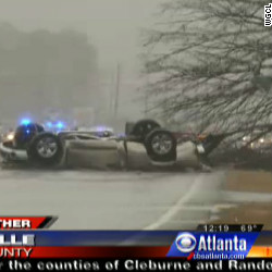

Interstate littered with cars after N. Georgia tornado
There are reports of numerous cars overturned on Interstate 75 after a tornado in Adairsville, north of Atlanta. LIVE BLOGNO AMNESTY
Don't reward the criminal actions of millions of illegal aliens by giving them citizenship.
Sign in and post comments here.
Please support our fight against illegal immigration by joining ALIPAC's email alerts here https://eepurl.com/cktGTn
-
01-30-2013, 02:47 PM #5Senior Member
- Join Date
- Aug 2008
- Location
- PARADISE (San Diego)
- Posts
- 99,040
High winds, tornadoes cause damage in Southeast
Is there severe weather near you? Share your photos and videos on iReport, but stay safe. (CNN) -- A weather system stretching from Michigan to the Louisiana coastline threw down high winds and spawned a handful of tornadoes Wednesday, including one ...CNN - 2 minutes ago
Related National Weather Service »
Tips for preparing for tornadoes Rockdale News
Severe storms moving eastward Baltimore Sun (blog) - by Scott Dance
In Depth:Powerful storms hit South, Midwest; tornadoes reported USA TODAY
See all 329 sources »
Related National Weather Service »

YouTubeseen on KTNV Las Vegas via YouTubedemo 945 - YouTube 
KXAN.comHigh winds, tornadoes possible in Texas - KXAN.com 
NBCNews.com (blog)
New York Daily News
San Francisco Chronicle
CBS News
San Francisco Chronicle
KSAT San Antonio
Charlotte Observer
WALA-TV FOX10
FOX43.com
WRAL.com
ABC15.com (KNXV-TV)
Wall Street Journal (blog)
Christian Science Monitor
GPB (blog)
Mother Nature Network
ABC2 News (blog)
Chattanooga Times Free Press
Examiner.com
WPTZ The Champlain Valley
Examiner.comNO AMNESTY
Don't reward the criminal actions of millions of illegal aliens by giving them citizenship.
Sign in and post comments here.
Please support our fight against illegal immigration by joining ALIPAC's email alerts here https://eepurl.com/cktGTn
-
01-30-2013, 07:10 PM #6Senior Member
- Join Date
- Aug 2008
- Location
- PARADISE (San Diego)
- Posts
- 99,040
FEMA Urges Southeast and Mid-Atlantic Residents to Monitor Conditions and Be Prepared for Severe Weather
Release date:
January 30, 2013
Release Number:
HQ-13-006
WASHINGTON -- The U.S. Department of Homeland Security's Federal Emergency Management Agency, through its regional offices in Chicago, Atlanta, Denton, Texas; Philadelphia, New York, and Boston, is closely monitoring the storm system that is forecast to affect the upper Ohio Valley southward to the central Gulf Coast and eastward to the Mid-Atlantic and Southeast coast.
FEMA has been in touch with its state counterparts, and also is in close contact with federal partners at the National Weather Service. The severe weather is forecast to include the threat of widespread damaging winds, along with the possibility of tornadoes, through the evening and overnight hours.
Although there have been no requests for federal assistance at this time, FEMA encourages all individuals in areas where severe weather is expected to monitor NOAA Weather Radio, and local news for severe weather updates and warnings and to always follow the direction provided by local officials. When natural disasters like severe weather and tornadoes strike, the first responders are local emergency and public works personnel, volunteers, humanitarian organizations, and numerous private interest groups who provide emergency assistance required to protect the public's health and safety and to meet immediate human needs.
Everyone should become familiar with the terms used to identify a severe weather hazard and discuss with your family what to do if a watch or warning is issued. Some of the more common terms used to describe severe weather and tornado hazards include the following:
- Severe Thunderstorm Watch - Tells you when and where severe thunderstorms are likely to occur. Watch the sky and stay tuned to NOAA Weather Radio, commercial radio or television for information.
- Severe Thunderstorm Warning - Issued when severe weather has been reported by spotters or indicated by radar. Warnings indicate imminent danger to life and property to those in the path of the storm.
- Tornado Watch - Tornadoes are possible. Remain alert for approaching storms. Watch the sky and stay tuned to NOAA Weather Radio, commercial radio or television for information.
- Tornado Warning - A tornado has been sighted or indicated by weather radar. Take shelter immediately.
For a complete listing of weather-related forecasts in your area, visit www.weather.gov
If you are in an area that is in the track of the storm system but has not yet been affected by the severe weather, it’s never too early to prepare:
- Keep up to date with local conditions – Follow TV and radio reports from your area, or visit www.weather.gov (http://mobile.weather.gov on your phone) for the latest forecast.
- Check your family’s emergency supply kit – Make sure you have food, water, medications, and other necessities to sustain you and your family for at least 72 hours. This includes a battery-powered radio, flashlight, extra batteries, cell phone charger, medicines, non-perishable food, and first aid supplies.
- Listen to the instructions of local officials. Local officials make decisions on sheltering in place or going to your pre-designated safe meeting location.
For more information on severe weather and tornado preparedness tips, visit www.ready.gov or www.listo.gov to find out how you can protect your family during emergencies.
Follow FEMA online at blog.fema.gov, www.twitter.com/fema, www.facebook.com/fema, and www.youtube.com/fema. Also, follow Administrator Craig Fugate's activities at www.twitter.com/craigatfema.
The social media links provided are for reference only. FEMA does not endorse any non-government websites, companies or applications.
FEMA's mission is to support our citizens and first responders to ensure that as a nation we work together to build, sustain, and improve our capability to prepare for, protect against, respond to, recover from, and mitigate all hazards.
Last Updated:
January 30, 2013 - 17:15
State or Region:
Region IV, Region III and Region V
http://www.fema.gov/news-release/2013/01/30/fema-urges-southeast-and-mid-atlantic-residents-monitor-conditions-and-beNO AMNESTY
Don't reward the criminal actions of millions of illegal aliens by giving them citizenship.
Sign in and post comments here.
Please support our fight against illegal immigration by joining ALIPAC's email alerts here https://eepurl.com/cktGTn
-
01-30-2013, 10:12 PM #7Senior Member
- Join Date
- Aug 2008
- Location
- PARADISE (San Diego)
- Posts
- 99,040

NBC4 Washington
PM Update: Tornado Watch until 2 am; heavy showers and gusty ...
Washington Post (blog)-23 minutes ago
6:40 p.m. update: A Tornado Watch has been issued for the D.C.-Baltimore area until 2 a.m. Severe storms currently to the southwest around ...NO AMNESTY
Don't reward the criminal actions of millions of illegal aliens by giving them citizenship.
Sign in and post comments here.
Please support our fight against illegal immigration by joining ALIPAC's email alerts here https://eepurl.com/cktGTn


 Reply With Quote

Durbin pushes voting rights for illegal aliens without public...
04-25-2024, 09:10 PM in Non-Citizen & illegal migrant voters