

Results 1 to 2 of 2
Thread Information
Users Browsing this Thread
There are currently 1 users browsing this thread. (0 members and 1 guests)
 LinkBack URL
 About LinkBacks
-
09-07-2013, 01:32 AM #1Senior Member


- Join Date
- May 2007
- Location
- South West Florida (Behind friendly lines but still in Occupied Territory)
- Posts
- 117,087
RAHMS CHICAGO: 53 HOMICIDES, 224 SHOT AND WOUNDED IN AUGUST
RAHMS CHICAGO: 53 HOMICIDES, 224 SHOT AND WOUNDED IN AUGUST
Posted on 7 September, 2013 by clyde

via Breitbart
No matter how Chicago Mayor Rahm Emanuel and Police Superintendant Garry McCarthy spin it by touting overall crime being down in the city, the numbers for 2013 are still horrifying.
The website HeyJackass.com, which keeps some pretty interesting data regarding Chicago crime statistics, reports that the city saw 53 homicides in August, with 41 deaths and 224 wounded as a result of shootings.
The August crime wave ended on a tragic note, with 11 people shot and killed over Labor Day weekend; more than 25 more were shot and wounded.
For September to date, there are already seven shooting homicides with another 29 people wounded. The city crime data portal shows that murders and shootings are down, but only when compared to 2012. When compared to 2011, the number of murders is almost identical. HeyJackass.com shows a total 309 homicides for 2013, and things dont seem to be getting any better.
http://gopthedailydose.com/2013/09/0...ded-in-august/Join our efforts to Secure America's Borders and End Illegal Immigration by Joining ALIPAC's E-Mail Alerts network (CLICK HERE)
-
09-07-2013, 01:33 AM #2Senior Member
- Join Date
- May 2007
- Location
- South West Florida (Behind friendly lines but still in Occupied Territory)
- Posts
- 117,087
Map: Where You Dont Want to Be When It Hits the Fan
Mac Slavo
www.SHTFplan.com
September 6th, 2013
Reader Views: 11,392
Comments (24)

When it hits the fan Americas population centers will explode in violence, looting, and total breakdown of law and order.
Its a theory put forth by numerous survival and relocation specialists, and one that makes complete sense if you consider what happens in a truly serious collapse-like scenario.
Survival Blog founder James Rawles calls them the golden horde:
In his recent documentary Strategic Relocation, retreat expert Joel Skousen echoes Rawles warnings:
Because of the urbanization of the U.S. population, if the entire eastern or western power grid goes down for more than a week, the cities will rapidly become unlivable. I foresee that there will be an almost unstoppable chain of events:
Power -> water -> food distribution -> law and order -> arson fires -> full scale looting
So, where should you be when it happens?
The number one threat that I concentrate on. Its not terrorism, its not natural disaster, its not even government or war.
The major threat is population density.
Because every crisis that threatens, even a local crisis, can turn exponential because of close proximity to people who cannot help themselves. Even good people panic in a crisis
To find the answer, lets consider where we shouldnt be.
Recent U.S. census data indicates that out of the 3000 counties in the United States, fully 50% of the population lives in just 146.
If you want to have any chance of surviving a wide-spread catastrophic event by avoiding the hordes that will be searching for critical resources in its aftermath, then check out the following map to get a visual reference of the areas you want to stay away from.
When considering your retreat locations or emergency evacuation routes, be familiar with the population densities of the area youre headed to, as well as those counties in your immediate vicinity.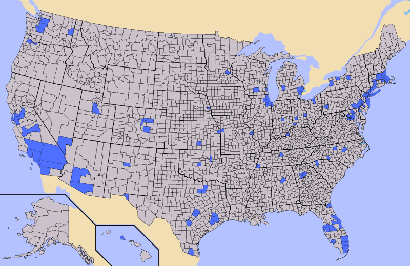
(For a complete list of the counties highlighted on this map click here)
In his book Patriots, James Rawles specifically points out that Highway 80, running through California, will be one of the busiest evacuation routes in the country as millions of people pour out of major cities to flee disaster or in search of food.
So, no matter where you are located, consider your proximity to high traffic thoroughfares going in and out of the city. During Hurricane Rita, which hit Houston several years ago, every major pipeline out of the city was jammed for hundreds of miles. Interstate 45 from Houston to Dallas was bumper to bumper traffic. Normally a 4 hour trip, those who didnt evacuate in time were stuck on the highway without food, gas, sanitation, or potable water for upwards of 15 hours.
This is why Joel Skousen suggests that those looking for strategic retreat locations or homes outside of major cities consider highway proximity. Be at least 5 7 miles away from any major thoroughfare, which is generally outside the range people want to venture off familiar roads, and far enough away to make any walkers too tired to attempt the trip without ample clean water and food.
If you have no choice but to be in a major metro area during a serious emergency situation, consider strategies that can help you remain sustainable in the city even in the midst of panic.
Hat tip Satori
Delivered by The Daily Sheeple
Contributed by Mac Slavo of www.SHTFplan.com.
When it hits the fan, dont say we didnt warn you. Mac Slavo is the editor of SHTFplan.com, a resource hub for alternative news, contrarian commentary and strategies that you can take to protect yourself from the coming global paradigm shift.
Please share: Spread the word to sheeple far and wide
http://www.thedailysheeple.com/map-w...the-fan_092013Join our efforts to Secure America's Borders and End Illegal Immigration by Joining ALIPAC's E-Mail Alerts network (CLICK HERE)


 Reply With Quote

Outrageous Sellout! University Of Utah Exceeds Double H-1B...
07-06-2026, 08:00 PM in General Discussion