

Results 1 to 10 of 115
Thread Information
Users Browsing this Thread
There are currently 1 users browsing this thread. (0 members and 1 guests)
 LinkBack URL
 About LinkBacks
Hybrid View


-
05-07-2026, 01:21 PM #1Super Moderator


- Join Date
- Feb 2024
- Posts
- 3,953
Footage From Lake Mead Reveals A Terrifying Collapse Nobody Expected
Credits:
Channel: The Lithosphere
Published: 5/7/26
9:53 minutes
-
05-16-2026, 03:23 PM #2Super Moderator
- Join Date
- Feb 2024
- Posts
- 3,953
Shocking Images Of Maine Lumber Mill Explosion - 1 Firefighter Dead, What ACTUALLY Happened
Credits:
Channel: Crisis Radar
Published: 5/16/26
10:41 minutes
-
05-23-2026, 01:30 PM #3Super Moderator
- Join Date
- Feb 2024
- Posts
- 3,953
Canada’s Most DANGEROUS Volcano WAKES UP - 25,004 People On DANGER ZONE ALERT
Credits:
Channel: Crisis Radar
Published: 5/23/26
14:26 minutes
-
06-06-2026, 03:56 PM #4Super Moderator
- Join Date
- Feb 2024
- Posts
- 3,953
Fatal Earthquakes CRACK OPEN Crater Lake - 711,340 Americans On DEATH ZONE ALERT
Credits:
Channel: Crisis Radar
Published: 6/6/26
9:28 minutes
-
06-20-2026, 11:58 AM #5Super Moderator
- Join Date
- Feb 2024
- Posts
- 3,953
NWS confirms EF3 tornado in Effingham County, seven tornadoes confirmed across central Illinois
https://watchers.news/2026/06/20/nws...tral-illinois/
ByRishav Kothari
Saturday, June 20, 2026
12:52 UTC
Follow us on Google News
The National Weather Service (NWS) Central Illinois office confirmed seven tornadoes across central Illinois following severe thunderstorms on June 17, 2026, including an EF3 tornado with peak winds of 241 km/h (150 mph) that tracked 42.2 km (26.2 miles) through Effingham County and injured two people. The surveys documented tornadoes affecting portions of Effingham, Jasper, Coles, Menard, Sangamon, Christian, Macon, Shelby, and Moultrie counties.

The Effingham County tornado was the strongest and most destructive of the outbreak. It touched down near Beecher City at 06:26 and remained on the ground until 06:58, reaching a maximum width of 457 m (1 500 feet).
Survey teams assigned the tornado an EF3 rating and estimated peak winds of 241 km/h (150 mph). Two injuries were reported associated to the twister.
The tornado initially produced EF0 and EF1 damage along Illinois Route 33 near Beecher City, snapping and uprooting large trees and damaging grain silos and farm outbuildings.
As it moved east through Shumway, it intensified to EF2 strength, snapping hardwood and softwood trees roughly two-thirds of the way up their trunks, removing the roof from a single-family residence, and destroying multiple farm buildings.
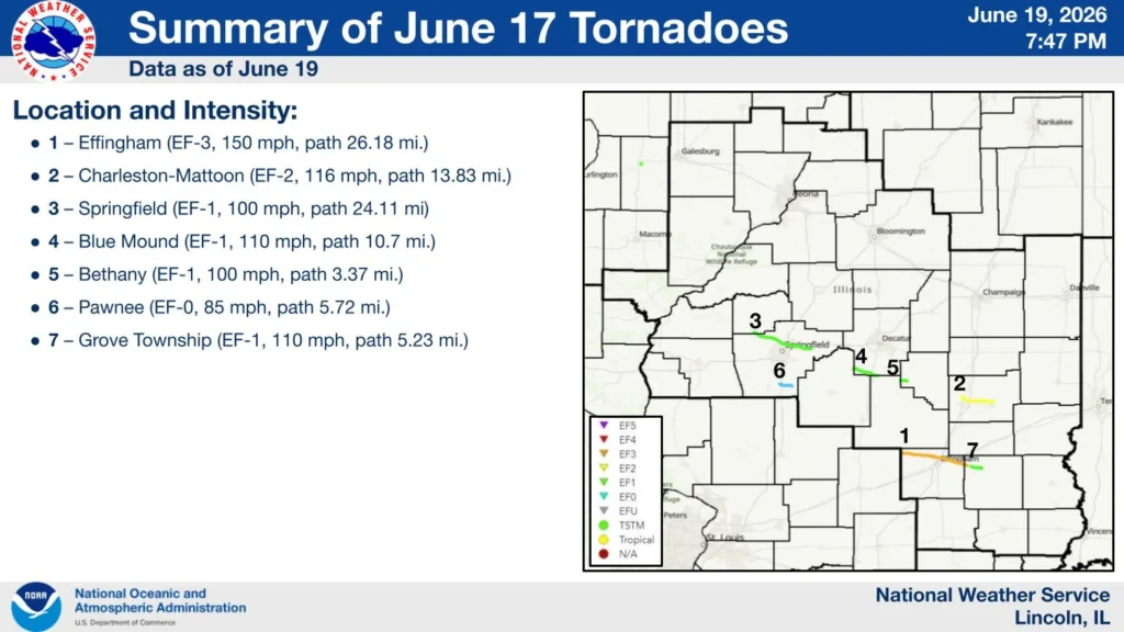 Image credit: NWS Central IllinoisThe most severe damage occurred north of Effingham along East 1800th Avenue, where NWS investigators found EF3 damage, including the destruction of a single-family home that suffered complete exterior wall collapse.
Additional EF3 damage occurred at nearby farmsteads, where large outbuildings were demolished and homes sustained complete roof loss and structural failure. After crossing U.S. Highway 45 in Effingham, the tornado destroyed a large metal building following failure of an X-brace system and threw a delivery van approximately 137 m (450 feet).
The tornado continued southeast across Interstate 70 and into the Teutopolis area, where it caused major tree damage and complete roof loss at several homes.
Near the intersection of Highway 40 and North 1950th Street, survey teams documented the destruction of large barns and outbuildings and the complete removal of a residence roof.
The tornado maintained EF3 intensity into rural Teutopolis, where peak winds were estimated at 225 km/h (140 mph) near North 2100th Street and East 1500th Avenue. Two homes were destroyed before the tornado crossed into Jasper County, weakened to EF2 intensity, and eventually lifted north of Island Grove.

The second strongest tornado developed about 6 km (4 miles) north of Mattoon and tracked southeast toward Charleston. Rated EF2, the tornado reached estimated peak winds of 187 km/h (116 mph), remained on the ground for 22 km (14 miles), and reached a maximum width of 732 m (800 yards). One injury occurred when a semi-truck was overturned on Interstate 57.
Survey teams documented damage to homes, farm buildings, electrical transmission lines and trees before the tornado crossed through the north side of Charleston, damaging the fairgrounds, outbuildings, and additional trees before lifting east of the city along Illinois Route 16.
Five additional tornadoes were confirmed elsewhere in central Illinois. An EF1 tornado tracked 39 km (24 miles) from southern Menard County into Sangamon County, first touching down near Salisbury.
In addition to extensive tree damage, it damaged a garage and the roof of a nearby home before continuing through northern Springfield, where it damaged more trees and blew in the garage door of a business. Portions of the path followed the same track as an EF1 tornado that struck the area on June 10 before dissipating west of Mechanicsburg.

Another EF1 tornado developed in the Griswold Conservation Area in northern Christian County and crossed into Macon County near Blue Mound. The tornado caused extensive tree damage, damaged structures in town, tore part of the roof from Meridian Elementary School, destroyed two grain bins south of the school, and downed electrical transmission lines.
It continued across U.S. Route 51 and into Shelby County, causing additional damage to trees and transmission infrastructure before lifting northeast of Moweaqua. Survey teams estimated peak winds of 177 km/h (110 mph), a path length of 17 km (11 miles), and a maximum width of 640 m (2 100 feet).
NWS also documented an EF1 tornado southwest of Bethany with peak winds of 161 km/h (100 mph) and a 5.5 km (3.4 mile) path. The tornado snapped softwood trees, removed large branches from hardwood trees, crossed from Christian County into Moultrie County, and lifted south of Bethany.

A separate EF1 tornado formed in Grove Township in Jasper County after the Effingham tornado underwent a cycling process. The tornado caused major roof damage to a two-story house, rolled an SUV, damaged an outbuilding, and snapped several large hardwood trees near North 300th Street.
Additional damage occurred along East 1700th Avenue, where homes, mobile homes, trees, and agricultural structures sustained impacts before the tornado lifted east of North 800th Street. The tornado had estimated peak winds of 177 km/h (110 mph), a path length of 8.4 km (5.2 miles), and a maximum width of 160 m (175 yards).
The final tornado surveyed by NWS was an EF0 that touched down west of Pawnee Junction near the Interstate 55 exit and tracked east through Comanche Village and Pawnee before dissipating southeast of town.
The tornado primarily caused tree damage along its 9.2 km (5.7-mile) path, although minor roof and soffit damage was also reported. Estimated peak winds reached 137 km/h (85 mph), and no injuries occurred.
References:
1 June 17, 2026 Severe Weather – NWS – June 19, 2026
Featured image credit: representational image of Spiritwood/Urbana EF3 tornado on June 20, 2025. Credit: Tanner Charles, NWS
Author profile
Articles

Rishav Kothari
I am an Assistant Editor and Severe Weather & Science Journalist at The Watchers, specializing in real-time severe weather coverage, geophysical event reporting, and research-driven scientific analysis. You can reach me at rishav(at)watchers(.)news.
Last edited by GaiaGoddess; 06-20-2026 at 12:02 PM.
-
06-29-2026, 02:42 PM #6Super Moderator
- Join Date
- Feb 2024
- Posts
- 3,953
Major to extreme heat risk forecast across central and eastern U.S. through the July 4 holiday
https://watchers.news/2026/06/29/maj...uly-4-holiday/
ByRishav Kothari
Monday, June 29, 2026
06:17 UTC
A strengthening upper-level ridge is forecast to intensify a prolonged and dangerous heat wave across much of the central and eastern United States through at least July 10, 2026, with temperatures in the low to upper 30s°C (90s to lower 100s°F) and heat index values reaching 38–43°C (100–110°F), locally up to 46°C (115°F).
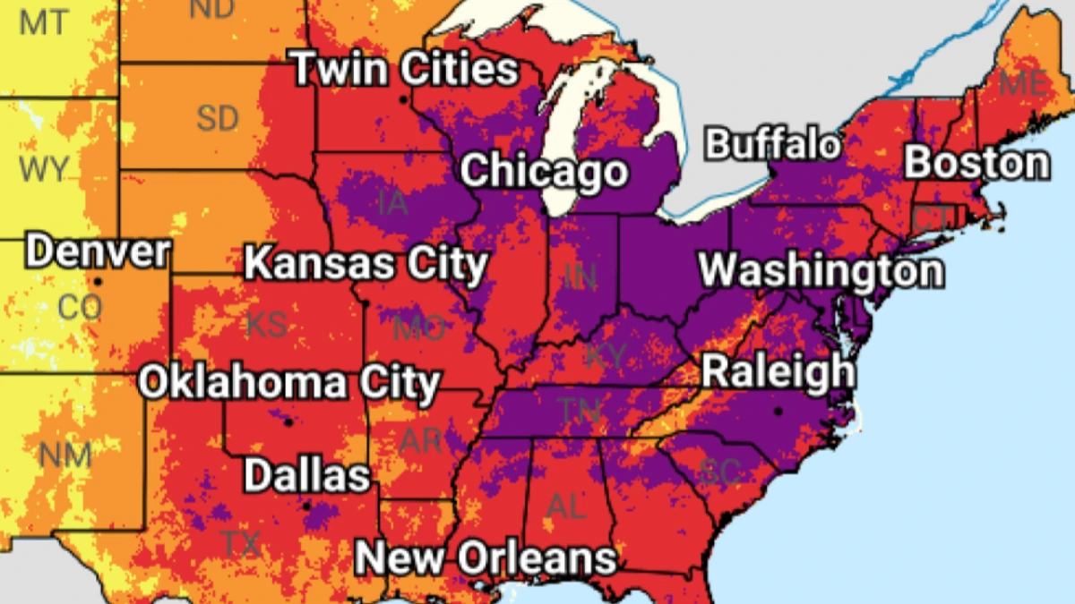
Image credit: NWS/WPC
A strengthening upper-level ridge is forecast to intensify a prolonged and dangerous heat wave across much of the central and eastern United States through at least July 10.
Temperatures in the low to upper 30s°C (90s to lower 100s°F), combined with high humidity, are forecast to produce heat index values of 38–43°C (100–110°F) across much of the region, with locally higher values reaching 46°C (115°F). The highest heat indices are expected across portions of the southern Plains, Mid-Mississippi Valley, and, by June 30, parts of the Mid-Atlantic.
Much of the central and eastern U.S. is forecast to experience Moderate to Major HeatRisk on June 29, increasing to Major to Extreme HeatRisk on June 30.
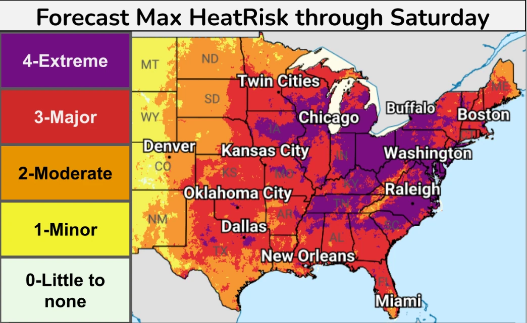 Image credit: NWS/WPC
Widespread Major to Extreme HeatRisk is forecast across the Lower Great Lakes, the Mississippi and Ohio valleys, and the Mid-Atlantic through July 4, increasing the likelihood of heat-related health impacts.
Overnight temperatures will remain unusually warm, with lows generally in the low to upper 20s°C (70s°F), including the mid to upper 20s°C (mid to upper 70s°F) in many locations, providing little to no overnight relief.
The combination of prolonged daytime heating and limited nighttime cooling will increase the risk of heat-related illness and may affect anyone without adequate hydration or access to cooling, although vulnerable populations remain at greatest risk.
The dangerous heat is expected to persist through July 4, with elevated heat risk continuing afterward. Moderate to extreme heat risk is forecast across parts of the eastern Plains, Mississippi Valley, Mid-Atlantic, and Southeast on July 6, while slight heat risk expands westward through July 10. Daytime heat index values of 38–41+°C (100–105+°F) and continued warm nights are expected to prolong heat stress.
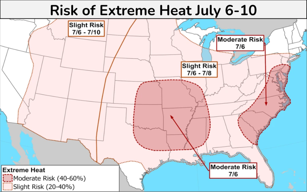 Image credit: NWS/WPC
The dangerous heat is expected to persist through the Independence Day holiday, with elevated heat risk continuing into early July across parts of the eastern Plains, Mississippi Valley, Mid-Atlantic, and Southeast.
Residents are urged to limit strenuous outdoor activities during the hottest part of the day, stay hydrated, and seek air-conditioned environments or cooling centers when available.
References:
1 Key messages for late June and early July heatwave – NWS/WPC – June 28, 2026
Author profile
Articles
Rishav Kothari
I am an Assistant Editor and Severe Weather & Science Journalist at The Watchers, specializing in real-time severe weather coverage, geophysical event reporting, and research-driven scientific analysis. You can reach me at rishav(at)watchers(.)news.
Post Tags:#heatwaves#united states of america#us heatwave#us weather
Last edited by GaiaGoddess; 06-29-2026 at 02:45 PM.
-
07-16-2026, 01:30 PM #7Super Moderator
- Join Date
- Feb 2024
- Posts
- 3,953
EF1 tornado in San Antonio, Texas
Large Guadalupe River flood wave prompts Flash Flood Emergency after confirmed EF1 tornado in San Antonio, Texas
https://watchers.news/2026/07/16/ef1...-across-texas/
By Rishav Kothari
Thursday, July 16, 2026
09:03 UTC
A large flood wave moved downstream along the Guadalupe River through the Texas Hill Country on July 16, 2026, prompting a Flash Flood Emergency from Center Point to Bergheim as emergency crews expanded rescues across south-central and western Texas. The event followed a preliminary EF1 tornado confirmed in northwest San Antonio on July 15, but the main active hazard had shifted to life-threatening flash flooding across the Guadalupe basin and Uvalde County.
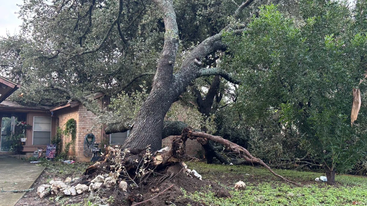
Storm-damaged tree in San Antonio following severe weather on July 15, 2026. Credit: CPS Energy
The National Weather Service (NWS) confirmed a preliminary EF1 tornado in northwest San Antonio, after surveying damage produced on July 15. The tornado touched down at approximately 12:44 UTC (07:44 LT), remained on the ground for about eight minutes, and produced estimated peak winds of 161 km/h (100 mph).
It began approximately 3 km (2 miles) southwest of the Interstate 10–Loop 1604 interchange and moved northeast for about 6.4 km (4 miles). The tornado then crossed Interstate 10 before dissipating just north of The Rim at approximately 12:52 UTC (07:52 LT).
Damage was reported near the University of Texas at San Antonio, The Rim, Camp Bullis, Crown Ridge, and the Dominion. A large section of the roof was torn from the Oasis Apartments on UTSA Boulevard, affecting three fourth-floor units, while trees, storefronts, signs, and electrical infrastructure were also damaged. No injuries were reported.
A Tornado Warning covering parts of Bexar, Comal, and Kendall counties remained in effect until 08:30 LT as the circulation moved northward. The tornado occurred during several days of severe weather and flooding across Texas, with a High Risk, level 4/4, of excessive rainfall in effect for parts of the Edwards Plateau, central Rio Grande Valley, and Hill Country until 12:00 UTC on July 16, followed by a Moderate Risk through 12:00 UTC on July 17.
No injuries were reported.
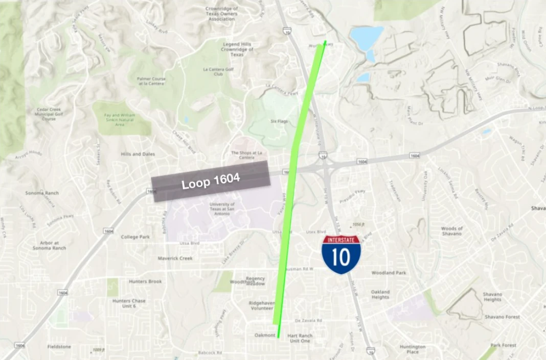
Path map for EF1 tornado in San Antonio, Texas on July 15, 2026. Credit: NWS/WPC


“Many of our neighborhoods, including the areas around UTSA, the Rim, Camp Bullis, Crown Ridge, Hills and Dales, and the Dominion, experienced significant damage as a tornado and severe weather moved through our community,” Councilwoman for District 8 Ivalis Meza Gonzalez said.
“Our crews continue working to restore power following today’s severe weather. As of 20:30 LT, 18 active outages are affecting approximately 310 customers across our service area, with 77 of those customers located near the Tanglewood Ridge and Hart Ranch neighborhoods on the Northwest Side,” CPS Energy said.
Damage assessments remained underway on July 16. Flash flood, severe thunderstorm and tornado warnings were in effect for parts of the NWS Austin/San Antonio forecast area early that day.

The Weather Prediction Center (WPC) maintained a High Risk, level 4/4, of excessive rainfall for portions of the Edwards Plateau, central Rio Grande Valley, and Texas Hill Country from 01:00 to 12:00 UTC on July 16. WPC said western Texas would remain the focus for heavy to excessive rainfall during the overnight and early morning hours.
Two circulation centers were supporting the continuing rainfall: one over the Hill Country and another between the Davis Mountains and the Edwards Plateau. High-resolution guidance showed increased probabilities of flash-flood guidance being exceeded, including a signal for rainfall approaching a 100-year average recurrence interval within parts of the High Risk area.
Parts of the Hill Country west of San Antonio had already received 254 to 406 mm (10 to 16 inches) of rain, according to WPC. An additional 102 to 203 mm (4 to 8 inches), with locally higher totals, was possible through early July 16.
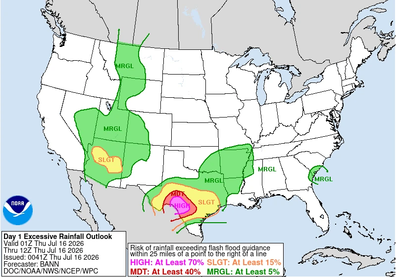 Image credit: NWS/WPC
The agency warned that significant to catastrophic flash flooding remains likely in the hardest-hit areas, urging residents to closely monitor forecasts and heed all warnings from local officials, particularly those living in flood-prone locations.
Although the threat is forecast to gradually diminish, heavy rainfall is expected to continue beyond Thursday. The WPC has issued a Moderate Risk (Level 3/4) of excessive rainfall for July 16-17 across portions of the Edwards Plateau, central Rio Grande Valley, and Hill Country.
Saturated soils and ongoing flooding will leave the region highly vulnerable to additional flash flooding from even modest rainfall totals.
A Flood Watch remains in effect for parts of the Hill Country, I-35 corridor, southern Edwards Plateau, and Rio Grande Plains through the evening of July 16.
The continuing threat followed high-water rescues, road closures, and shelter operations across parts of south-central Texas on July 14, when heavy rainfall produced flash flooding west of San Antonio.
Updates
15:33 UTC, on July 16
A Flash Flood Emergency was in effect for the Guadalupe River from Center Point to Bergheim on Thursday morning, July 16, as a large flood wave moved downstream through the Texas Hill Country.
Meteorologists at the NWS office in Austin/San Antonio said at 09:31 CDT (14:31 UTC) that emergency management reported heavy rain along the Guadalupe River and that flash flooding was already occurring. The warning covered parts of Kerr and Kendall counties, including Kerrville, Comfort, Waring, Sisterdale, Center Point, and Crown.
NWS described the situation as life-threatening and told people along the affected reach to move to higher ground immediately. The warning included low-water crossings, small creeks and streams, urban areas, highways, streets, and underpasses among the expected impact areas. Weather officials warned people not to travel unless fleeing an area subject to flooding or under an evacuation order.
The emergency warning followed rapid river rises across the Guadalupe basin. Gauges in some locations along the Guadalupe River rose by more than 9 m (30 feet) in a matter of hours overnight Thursday, including a gauge outside Kerrville that rose 9.7 m (32 feet) in four hours. Near Hunt, close to Camp Mystic, the river reached about 6.3 m (20.5 feet), according to USGS data.
Farther west, NWS extended a Flash Flood Warning at 09:35 CDT (14:35 UTC) for parts of Bandera, Kerr, and Real counties, including Vanderpool, Hunt, Mountain Home, Rio Frio, Kerr Wildlife Management Area, and Lost Maples State Natural Area. NWS said 76 to 305 mm (3 to 12 inches) of rain had fallen in the warned area, with flash flooding ongoing or expected to begin shortly.
Another Flash Flood Warning was extended at 09:48 CDT (14:48 UTC) for parts of Kinney, Maverick, and Val Verde counties, including Del Rio, Brackettville, Laughlin AFB, Lake View, Cienegas Terrace, and areas around Amistad Reservoir. NWS said 51 to 152 mm (2 to 6 inches) of rain had fallen there, rainfall rates of 51 to 102 mm (2 to 4 inches) per hour were expected, and another 76 to 152 mm (3 to 6 inches) of rain was possible.
Uvalde remained one of the main operational concern areas after floodwaters cut off outside access overnight. Uvalde police said rescues had been occurring overnight, with multiple people trapped in vehicles. County officials were deploying boats and planning helicopter operations after daybreak, while Texas Game Wardens rescued more than 40 people, mostly in the Uvalde County area.
Governor Greg Abbott said more than 75 people had been rescued, most of them stranded motorists, during a Wednesday briefing. At least 114 streets and highways were washed out or affected at the peak of Wednesday’s downpours. Abbott issued a disaster declaration for 59 counties, activating emergency response plans and 1 300 personnel from more than 30 agencies.
The NWS Austin/San Antonio office said a Flood Watch remains in effect for parts of the Hill Country, I-35 corridor, southern Edwards Plateau, and Rio Grande Plains through Thursday evening.
The office maintained a Level 4 of 4 High Risk for flooding rain over portions of the U.S. 90 corridor west of San Antonio, including the southern Edwards Plateau, Rio Grande Plains, and western Hill Country, where considerable to locally catastrophic flash-flood impacts were expected.
Additional rainfall of 254 to 381 mm (10 to 15 inches) was possible in isolated pockets, with broader totals of 51 to 152 mm (2 to 6 inches) possible across the Flood Watch area.
Author profile
Articles
Rishav Kothari
I am an Assistant Editor and Severe Weather & Science Journalist at The Watchers, specializing in real-time severe weather coverage, geophysical event reporting, and research-driven scientific analysis. You can reach me at rishav(at)watchers(.)news.
Last edited by GaiaGoddess; 07-16-2026 at 01:40 PM.


 Reply With Quote
Similar Threads
-
The dying of the West: Lake Mead and Lake Powell may not refill “in our lifetimes” wa
By Airbornesapper07 in forum Other Topics News and IssuesReplies: 1Last Post: 02-08-2023, 08:32 AM -
Hoover Dam, Lake Mead officers getting 52,000 rounds of ammo
By JohnDoe2 in forum Other Topics News and IssuesReplies: 1Last Post: 07-13-2015, 11:18 AM -
Boats roll on Strip to protest Lake Mead closure .... and so it begins
By AirborneSapper7 in forum General DiscussionReplies: 2Last Post: 10-08-2013, 03:01 PM -
Drought has Lake Mead at historic low
By JohnDoe2 in forum Other Topics News and IssuesReplies: 0Last Post: 11-01-2010, 01:36 PM -
Lake Mead sinks to a new historic low: Ariz. could experienc
By AirborneSapper7 in forum Other Topics News and IssuesReplies: 1Last Post: 10-20-2010, 03:37 AM


This isn't from a zombie movie by an African invasion of Spain |...
07-31-2026, 11:13 PM in Videos about Illegal Immigration, refugee programs, globalism, & socialism