

Results 101 to 110 of 242
Thread Information
Users Browsing this Thread
There are currently 1 users browsing this thread. (0 members and 1 guests)
 LinkBack URL
 About LinkBacks
-
07-13-2026, 12:07 PM #101Super Moderator


- Join Date
- Feb 2024
- Posts
- 4,414
Gov. Walz Declares Emergency & Mobilizes Nat'l Guard to Assist with Wildfire Response
Governor Walz Declares Peacetime Emergency and Mobilizes the National Guard to Assist with Wildfire Response
https://mn.gov/governor/newsroom/pre...id=1055-749149
May 17, 2026
[ST. PAUL, MN] – Governor Tim Walz today declared a peacetime emergency and authorized additional state assistance to support ongoing wildfire response efforts in northern Minnesota.
“Unpredictable and fast-moving wildfires are putting Minnesota communities at risk,” said Governor Walz. “This emergency declaration ensures we can fully mobilize the resources needed to protect lives, support evacuations, and help communities respond and recover. I’m grateful to the firefighters, members of the Minnesota National Guard, andall our first responders working around the clock to keep Minnesotans safe.”
The declaration comes as unusually dry, hot, and windy conditions have created dangerous wildfire risk across much of the state. Since May 15, multiple fires have ignited and spread across portions of Lake, Crow Wing, and St. Louis Counties, threatening lives, property, and critical infrastructure.Among the largest active fires are the Steward Trail Fire near Two Harbors, estimated at 355 acres, and the Flanders Fire in Crow Wing County, estimated at 1,000 acres. Current weather conditions pose a continued risk for rapid fire growth and spread.
The Minnesota Department of Public Safety’s Division of Homeland Security and Emergency Management (HSEM) is coordinating closely with state and local partners to support fire suppression, evacuation efforts, and emergency response operations. Responding agencies include the Minnesota Department of Natural Resources, Minnesota Department of Transportation, the Minnesota Interagency Fire Center, and local emergency responders. At the request of the Department of Natural Resources, the Executive Order authorizes the Minnesota National Guard to provide personnel, equipment, and resources to assist with wildfire suppression and emergency response efforts.
The costs of state assistance will be paid from the general fund in accordance with state law. The peacetime emergency is effective immediately and will remain in place until emergency conditions subside or June 7, 2026, whichever occurs first.
-
07-16-2026, 01:30 PM #102Super Moderator
- Join Date
- Feb 2024
- Posts
- 4,414
EF1 tornado in San Antonio, Texas
Large Guadalupe River flood wave prompts Flash Flood Emergency after confirmed EF1 tornado in San Antonio, Texas
https://watchers.news/2026/07/16/ef1...-across-texas/
By Rishav Kothari
Thursday, July 16, 2026
09:03 UTC
Follow us on Google News
A large flood wave moved downstream along the Guadalupe River through the Texas Hill Country on July 16, 2026, prompting a Flash Flood Emergency from Center Point to Bergheim as emergency crews expanded rescues across south-central and western Texas. The event followed a preliminary EF1 tornado confirmed in northwest San Antonio on July 15, but the main active hazard had shifted to life-threatening flash flooding across the Guadalupe basin and Uvalde County.
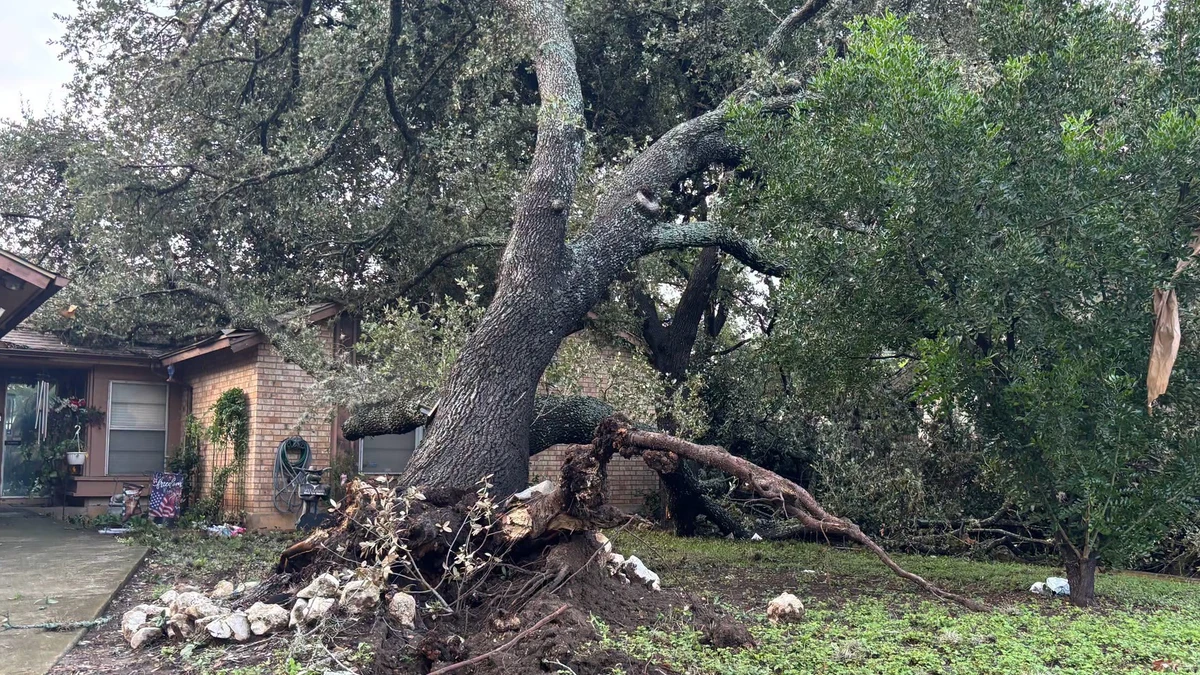
Storm-damaged tree in San Antonio following severe weather on July 15, 2026. Credit: CPS Energy
The National Weather Service (NWS) confirmed a preliminary EF1 tornado in northwest San Antonio, after surveying damage produced on July 15. The tornado touched down at approximately 12:44 UTC (07:44 LT), remained on the ground for about eight minutes, and produced estimated peak winds of 161 km/h (100 mph).
It began approximately 3 km (2 miles) southwest of the Interstate 10–Loop 1604 interchange and moved northeast for about 6.4 km (4 miles). The tornado then crossed Interstate 10 before dissipating just north of The Rim at approximately 12:52 UTC (07:52 LT).
Damage was reported near the University of Texas at San Antonio, The Rim, Camp Bullis, Crown Ridge, and the Dominion. A large section of the roof was torn from the Oasis Apartments on UTSA Boulevard, affecting three fourth-floor units, while trees, storefronts, signs, and electrical infrastructure were also damaged. No injuries were reported.
A Tornado Warning covering parts of Bexar, Comal, and Kendall counties remained in effect until 08:30 LT as the circulation moved northward. The tornado occurred during several days of severe weather and flooding across Texas, with a High Risk, level 4/4, of excessive rainfall in effect for parts of the Edwards Plateau, central Rio Grande Valley, and Hill Country until 12:00 UTC on July 16, followed by a Moderate Risk through 12:00 UTC on July 17.
No injuries were reported.
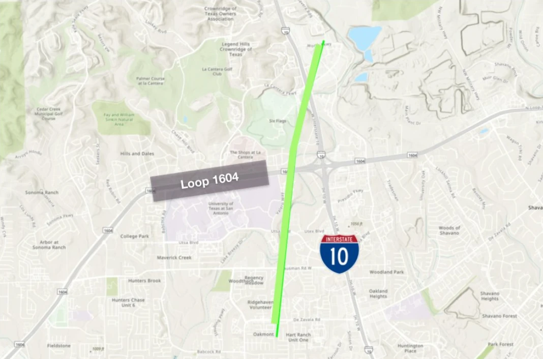
Path map for EF1 tornado in San Antonio, Texas on July 15, 2026. Credit: NWS/WPC


“Many of our neighborhoods, including the areas around UTSA, the Rim, Camp Bullis, Crown Ridge, Hills and Dales, and the Dominion, experienced significant damage as a tornado and severe weather moved through our community,” Councilwoman for District 8 Ivalis Meza Gonzalez said.
“Our crews continue working to restore power following today’s severe weather. As of 20:30 LT, 18 active outages are affecting approximately 310 customers across our service area, with 77 of those customers located near the Tanglewood Ridge and Hart Ranch neighborhoods on the Northwest Side,” CPS Energy said.
Damage assessments remained underway on July 16. Flash flood, severe thunderstorm and tornado warnings were in effect for parts of the NWS Austin/San Antonio forecast area early that day.

The Weather Prediction Center (WPC) maintained a High Risk, level 4/4, of excessive rainfall for portions of the Edwards Plateau, central Rio Grande Valley, and Texas Hill Country from 01:00 to 12:00 UTC on July 16. WPC said western Texas would remain the focus for heavy to excessive rainfall during the overnight and early morning hours.
Two circulation centers were supporting the continuing rainfall: one over the Hill Country and another between the Davis Mountains and the Edwards Plateau. High-resolution guidance showed increased probabilities of flash-flood guidance being exceeded, including a signal for rainfall approaching a 100-year average recurrence interval within parts of the High Risk area.
Parts of the Hill Country west of San Antonio had already received 254 to 406 mm (10 to 16 inches) of rain, according to WPC. An additional 102 to 203 mm (4 to 8 inches), with locally higher totals, was possible through early July 16.
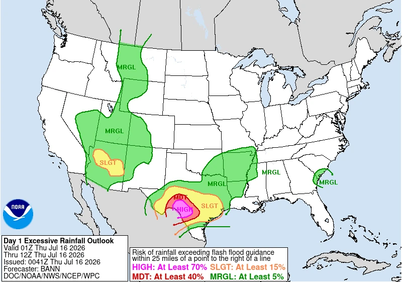 Image credit: NWS/WPC
The agency warned that significant to catastrophic flash flooding remains likely in the hardest-hit areas, urging residents to closely monitor forecasts and heed all warnings from local officials, particularly those living in flood-prone locations.
Although the threat is forecast to gradually diminish, heavy rainfall is expected to continue beyond Thursday. The WPC has issued a Moderate Risk (Level 3/4) of excessive rainfall for July 16-17 across portions of the Edwards Plateau, central Rio Grande Valley, and Hill Country.
Saturated soils and ongoing flooding will leave the region highly vulnerable to additional flash flooding from even modest rainfall totals.
A Flood Watch remains in effect for parts of the Hill Country, I-35 corridor, southern Edwards Plateau, and Rio Grande Plains through the evening of July 16.
The continuing threat followed high-water rescues, road closures, and shelter operations across parts of south-central Texas on July 14, when heavy rainfall produced flash flooding west of San Antonio.
Updates
15:33 UTC, on July 16
A Flash Flood Emergency was in effect for the Guadalupe River from Center Point to Bergheim on Thursday morning, July 16, as a large flood wave moved downstream through the Texas Hill Country.
Meteorologists at the NWS office in Austin/San Antonio said at 09:31 CDT (14:31 UTC) that emergency management reported heavy rain along the Guadalupe River and that flash flooding was already occurring. The warning covered parts of Kerr and Kendall counties, including Kerrville, Comfort, Waring, Sisterdale, Center Point, and Crown.
NWS described the situation as life-threatening and told people along the affected reach to move to higher ground immediately. The warning included low-water crossings, small creeks and streams, urban areas, highways, streets, and underpasses among the expected impact areas. Weather officials warned people not to travel unless fleeing an area subject to flooding or under an evacuation order.
The emergency warning followed rapid river rises across the Guadalupe basin. Gauges in some locations along the Guadalupe River rose by more than 9 m (30 feet) in a matter of hours overnight Thursday, including a gauge outside Kerrville that rose 9.7 m (32 feet) in four hours. Near Hunt, close to Camp Mystic, the river reached about 6.3 m (20.5 feet), according to USGS data.
Farther west, NWS extended a Flash Flood Warning at 09:35 CDT (14:35 UTC) for parts of Bandera, Kerr, and Real counties, including Vanderpool, Hunt, Mountain Home, Rio Frio, Kerr Wildlife Management Area, and Lost Maples State Natural Area. NWS said 76 to 305 mm (3 to 12 inches) of rain had fallen in the warned area, with flash flooding ongoing or expected to begin shortly.
Another Flash Flood Warning was extended at 09:48 CDT (14:48 UTC) for parts of Kinney, Maverick, and Val Verde counties, including Del Rio, Brackettville, Laughlin AFB, Lake View, Cienegas Terrace, and areas around Amistad Reservoir. NWS said 51 to 152 mm (2 to 6 inches) of rain had fallen there, rainfall rates of 51 to 102 mm (2 to 4 inches) per hour were expected, and another 76 to 152 mm (3 to 6 inches) of rain was possible.
Uvalde remained one of the main operational concern areas after floodwaters cut off outside access overnight. Uvalde police said rescues had been occurring overnight, with multiple people trapped in vehicles. County officials were deploying boats and planning helicopter operations after daybreak, while Texas Game Wardens rescued more than 40 people, mostly in the Uvalde County area.
Governor Greg Abbott said more than 75 people had been rescued, most of them stranded motorists, during a Wednesday briefing. At least 114 streets and highways were washed out or affected at the peak of Wednesday’s downpours. Abbott issued a disaster declaration for 59 counties, activating emergency response plans and 1 300 personnel from more than 30 agencies.
The NWS Austin/San Antonio office said a Flood Watch remains in effect for parts of the Hill Country, I-35 corridor, southern Edwards Plateau, and Rio Grande Plains through Thursday evening.
The office maintained a Level 4 of 4 High Risk for flooding rain over portions of the U.S. 90 corridor west of San Antonio, including the southern Edwards Plateau, Rio Grande Plains, and western Hill Country, where considerable to locally catastrophic flash-flood impacts were expected.
Additional rainfall of 254 to 381 mm (10 to 15 inches) was possible in isolated pockets, with broader totals of 51 to 152 mm (2 to 6 inches) possible across the Flood Watch area.
Author profile
Articles

Rishav Kothari
I am an Assistant Editor and Severe Weather & Science Journalist at The Watchers, specializing in real-time severe weather coverage, geophysical event reporting, and research-driven scientific analysis. You can reach me at rishav(at)watchers(.)news.
Last edited by GaiaGoddess; 07-16-2026 at 01:40 PM.
-
07-17-2026, 01:07 PM #103Super Moderator
- Join Date
- Feb 2024
- Posts
- 4,414
Tsunami Threat: Big 7.4M Earthquake Hits Mexico's Coast, Yellowstone and Florida Mystery Quake
Credits:
Channel: Dahboo77
Published: 7/17/26
3:16 minutes
-
07-21-2026, 12:04 PM #104Super Moderator
- Join Date
- Feb 2024
- Posts
- 4,414
Tropical Storm Bertha brings flash flood and storm surge threat from Florida to Louisiana
ByTeo Blašković
Tuesday, July 21, 2026 07:29 UTC
Tropical Storm Bertha, the second named storm of the 2026 Atlantic hurricane season, formed over the northeastern Gulf at 19:00 CDT on July 20, 2026 (00:00 UTC on July 21) and strengthened to 85 km/h (50 mph) by 06:00 UTC. A Tropical Storm Warning and Storm Surge Watch are in effect along sections of the northern Gulf Coast, where heavy rainfall, flash flooding, coastal inundation, dangerous surf, and rip currents were forecast from western Florida into southern Louisiana.
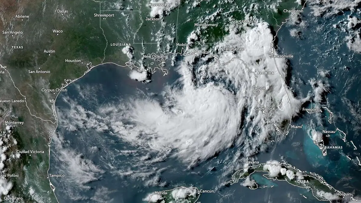
Tropical Depression Two (soon to become Tropical Storm Bertha) satellite image at 22:50 UTC on July 20, 2026. Credit: NOAA/GOES-East, Zoom Earth, The WatchersKey messages:
- Bertha is expected to bring tropical storm conditions to portions of the Gulf Coast from Alabama westward to southeastern Louisiana Tuesday night and Wednesday, July 21 and 22, where a Tropical Storm Warning is in effect. Tropical storm conditions are possible for portions of the Florida Panhandle, Metro New Orleans, and the southern Gulf Coast of Louisiana, where a Tropical Storm Watch is in effect.
- A Storm Surge Watch is in effect for the Alabama, Mississippi, and southeastern Louisiana coasts, where a life-threatening storm surge is possible.
- Interests elsewhere in Louisiana and Texas should monitor the progress of this system, as additional watches or warnings could be required for portions of that area on Tuesday.
- Areas of flash flooding will be possible through Thursday along the Gulf Coast and adjacent inland locations from western Florida north of Fort Myers to southern Louisiana with isolated instances of flash flooding possible westward into portions of Texas coast later in the week.
At 01:00 CDT (06:00 UTC) on July 21, Bertha’s center was located about 205 km (125 miles) south of Panama City, Florida, and 320 km (200 miles) southeast of Mobile, Alabama. The National Hurricane Center (NHC) reported that the storm was moving northwest at 4 km/h (2 mph), with a minimum central pressure of 998 hPa. Tropical-storm-force winds extended as far as 110 km (70 miles) from the center.
A Tropical Storm Warning is in effect from the Alabama–Florida border westward to the Jefferson/Plaquemines Parish border in Louisiana. Tropical-storm conditions are expected somewhere within the warning area within 36 hours.
A Tropical Storm Watch is in effect from the Bay/Gulf County line in Florida westward to the Florida–Alabama border and from west of the Jefferson/Plaquemines Parish border to Morgan City, Louisiana. The watch includes metropolitan New Orleans, Lake Pontchartrain, and Lake Maurepas. Tropical storm conditions are possible in the Florida Panhandle later on July 21 and in watched portions of Louisiana from late July 21 into July 22.
A Storm Surge Watch extends from the Alabama–Florida border to the mouth of the Mississippi River, indicating the possibility of life-threatening inundation from rising coastal water within 48 hours. The NHC said additional watches or warnings could be required later on July 21.
Peak water levels of 0.6–1.2 m (2–4 feet) above normally dry ground are forecast from the mouth of the Mississippi River to the Alabama–Florida border if the surge coincided with high tide. Levels of 0.3–0.9 m (1–3 feet) were forecast from Morgan City to the mouth of the Mississippi River, in Lake Pontchartrain, and along the Florida coast from Indian Pass to Chassahowitzka.
The deepest water was expected along the immediate coast, with inundation dependent on Bertha’s track, local coastal features, and the timing of the surge relative to the tidal cycle.
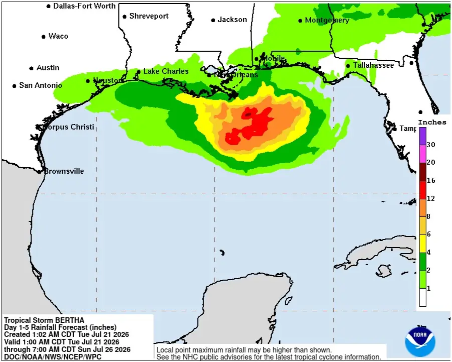 Tropical Storm Bertha rainfall forecast from July 21 to 26, 2026. Credit: NWS/NHC
Bertha is forecast to produce 50–100 mm (2–4 inches) of rainfall through Thursday, July 23, along the Gulf Coast and adjacent inland locations from western Florida into southern Louisiana, including southern Alabama and Mississippi, with isolated totals near 200 mm (8 inches) possible. This could produce flash flooding, especially in urban areas.
Swells generated by Bertha are affecting sections of Florida’s Gulf Coast and are forecast to spread westward during the week. Weather officials warned that the swells would produce life-threatening surf and rip-current conditions.
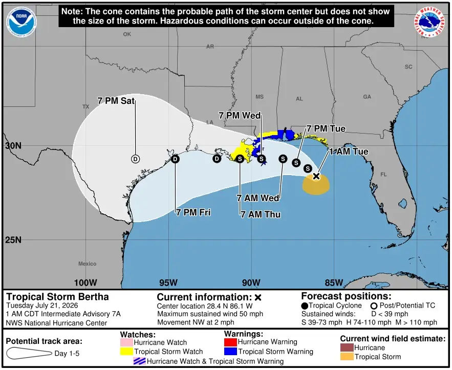 Tropical Storm Bertha NHC forecast track at 06:00 UTC on July 21, 2026. Credit: NWS/NHC
The NHC forecast a slow northwestward to west-northwestward movement on July 21, followed by a turn toward the west during the middle of the week. Bertha was expected to move near or along the northern Gulf Coast during the following several days.
Bertha is expected to move slowly northwest to west-northwest on July 21 before turning westward during the middle of the week. On the forecast track, the storm is expected to move near or along the northern Gulf Coast during the following several days.
References:
1 Tropical Storm Bertha Intermediate Advisory Number 7A – NWS/NHC – 06:00 UTC on July 21, 2026
Author profile
Articles

Teo Blašković
I'm a dedicated researcher, journalist, and editor at The Watchers. With over 20 years of experience in the media industry, I specialize in hard science news, focusing on extreme weather, seismic and volcanic activity, space weather, and astronomy, including near-Earth objects and planetary defense strategies. You can reach me at teo /at/ watchers.news.
Last edited by GaiaGoddess; 07-21-2026 at 12:07 PM.
-
07-25-2026, 04:54 PM #105Super Moderator
- Join Date
- Feb 2024
- Posts
- 4,414
Weather Warfare: Monster Heat Dome to Roast US with Dangerous Temperatures Hotter Than the Sahara
Credits:
Channel: Dahboo77
Published: 7/25/26
1:36 minutes
Summary
A monster heat dome is set to engulf a vast swath of the US, sending temperatures into the triple digits for days.
The heat will stretch from Arizona and Texas through to the Plains and northern Rockies while fueling thunderstorms along its eastern edge.
AccuWeather meteorologists predicted the lowest temperature will be 101°F in Denver, Colorado but the highest will be experienced in Phoenix, Arizona where it will be 119°F - hotter than the Sahara.
The hottest conditions are expected from Friday through Monday, with temperatures climbing 10 to 20 degrees above historical averages.
Many locations across the southern Plains could reach 100°F or higher for several consecutive days, while AccuWeather RealFeel temperatures are forecast to soar to between 105°F and 110°F.
'RealFeel Temperatures in that range are considered 'dangerous' and, according to the scale, can lead to heat cramps, heat exhaustion or heatstroke in individuals exposed to them for extended periods,' AccuWeather said.
Phoenix will bear the brunt of the heat, with temperatures forecast to reach 117°F Friday before soaring to 119°F Saturday.
AccuWeather Senior Meteorologist Joe Lundberg said, 'The core of the brutal heat will gradually shift out of Montana and the Dakotas through Sunday and head farther south and east as we go into next week.'
Amarillo, Texas, could hit 105°F Monday and 106°F Tuesday, while Billings, Montana, is forecast to reach 106°F Friday, 104°F Saturday and 102°F Sunday.
Rapid City, South Dakota, could also reach 106°F Saturday before temperatures dip slightly to 104°F Sunday.
Denver is expected to hit 100°F Saturday and 101°F Sunday, while Salt Lake City could endure highs of 104°F throughout the weekend.
The heat dome will retreat westward, but forecasters warn it is unlikely to stay there for the rest of the summer.
Until then, more temperature records could fall in cities including Billings, Montana, and Bismarck, North Dakota.
'When the intense heat backs off next week, most days will remain in the 90s through next week in that area,' added Lundberg.
'Meanwhile, the heat will escalate farther south in Kansas, Oklahoma, Texas and portions of the Mississippi Valley.'
In the major cities of Kansas City, St Louis and Memphis, temperatures will be near or above the century mark for multiple days by early next week, marking the hottest weather of the season thus far.
'Not only will it be extremely hot, but it will be exceptionally humid as well, particularly over the Mississippi Valley,' warned Lundberg.
'The combination of the two will drive AccuWeather RealFeel Temperatures to 110 degrees or higher.'
Thunderstorms arriving Tuesday night into Wednesday could bring some relief from the extreme heat, but the cooldown will be limited.
Temperatures are expected to fall into the low to mid-90s across much of the region through the middle of next week, although RealFeel temperatures could still reach 100°F during the afternoon.
Paul Pasetlok, AccuWeather lead long-range expert, said: 'Two things are driving this heat wave: long-term drought and a fast-emerging El Niño that is bringing persistent high pressure to the Northwest, Great Basin, and northern Rockies.
'These two are working together. The dry ground heats up intensely from the strong mid-summer sun, while the rapidly intensifying El Niño is contributing to high pressure blocking cooling rains from occurring.
'It's not an extremely intense high, but it's a stubborn one, and it's fueling heat that's spread into the Midwest as well.'
#breakingnews #breaking #heatdome
https://www.dailymail.com/sciencetech...
https://x.com/WeatherProf/status/2081...
-
07-26-2026, 01:12 PM #106Super Moderator
- Join Date
- Feb 2024
- Posts
- 4,414
Apocalyptic Wildfires: INSANE Wall of Fire in Spain, France Orders Largest Evacuation Since WWII
Credits:
Channel: Dahboo77
Published: 7/26/26
2:17 minutes
Summary
Thousands of firefighters are battling fast-moving wildfires spreading across Spain and France as extreme heat and strong winds forced more than 300,000 people to evacuate or shelter in place near Madrid, Valencia and Bordeaux.
Socialist Spanish Prime Minister Pedro Sánchez said fires burned about 20,000 hectares over the past 24 hours, with more than 105,000 people affected and two deaths reported so far. France evacuated more than 220,000 people in the Gironde region and mobilized 1,500 troops as roughly 30 fires spread near Bordeaux.
CNN reporter Max Saltman spoke with wine expert Nicolle Croft, who said the 2026 vintage across Bordeaux is safe for now, but there are mounting concerns.
Saltman continued:
As wildfires burn west of Bordeaux, one of France's most famous wine-producing regions, concerned oenophiles have called wine expert Nicolle Croft to voice concern over the fate of 2026 vintage.
"A lot of people are contacting me from around the world hearing all these terrible stories, but actually the vineyards are not impacted at the moment," Croft, a tour guide based in Bordeaux, told CNN. "But we're all very upset because there are people losing homes."
Croft said at this time of year, the grapes aren't yet large enough to absorb wildfire smoke – a phenomenon known in winemaking as "smoke taint."
"We won't be harvesting until the beginning of September," Croft said, "so there's still time."
Dr. Phil Crews, a winemaker and chemist at the University of California, Santa Cruz, explained that unripe grapes aren't as vulnerable to smoke taint. Young grapes lack sugars that would otherwise bind with bitter-tasting phenols in wildfire smoke.
The out-of-control situation with the unprecedented wildfires in south-west France got to be so bad that President Emmanuel Macron tasked his Prime Minister, Sebastien Lecornu, with calling another government crisis meeting for today.
“An ‘unprecedented’ wildfire tearing through southwest France is heading towards the city of Bordeaux, an official said Friday, warning many thousands more people would probably be evacuated.
‘In each of the municipalities affected by the fire’s path, every resident, whether a regular inhabitant or a temporary resident, will receive an alert from us on their mobile phone… giving them the starting signal’, said regional prefect Sophie Brocas, mentioning the town of Saint-Medard-en-Jalles northwest of Bordeaux.”
#breakingnews #france #spain #wildfire
https://www.thegatewaypundit.com/2026...
https://www.zerohedge.com/weather/fra...
https://x.com/RT_Visual_on_X/status/2...
-
07-27-2026, 01:35 PM #107Super Moderator
- Join Date
- Feb 2024
- Posts
- 4,414
Oregon Fire Disaster Escalates | Bench & Beachcomb Merge Into 40,000+ Acre Inferno
Credits:
Channel: Severe Weather USA
Published: 7/27/26
12:56 minutes
-
07-27-2026, 04:52 PM #108Super Moderator
- Join Date
- Feb 2024
- Posts
- 4,414
Power Emergency: Blackout Fears Erupt as 20 Million People in 17 States Put On Alert by DOE
Credits:
Channel: Dahboo77
Published: 7/27/26
2:21 minutes
Summary
Blackout fears are growing for 20 million Americans as extreme heat pushes the power grid toward its limits.
The US Department of Energy (DOE) on Sunday authorized the operator serving parts of 17 states to activate idle power sources in an effort to keep the lights on.
The move allows backup plants that are normally switched off to generate extra electricity if surging demand threatens to overwhelm the grid.
The emergency order covers Arizona, Arkansas, Colorado, Iowa, Kansas, Louisiana, Minnesota, Missouri and Montana. It also includes Nebraska, New Mexico, North Dakota, Oklahoma, South Dakota, Texas, Utah and Wyoming.
The move gives Southwest Power Pool (SPP), which oversees the central US grid, permission to deploy backup generators if electricity supplies become strained.
It is the final step before a Level 3 Energy Emergency Alert, which could trigger rolling blackouts to prevent a wider collapse.
The order will remain in effect through August 3 to 'mitigate the risk of blackouts,' according to the DOE.
It comes as 40 million Americans face extreme heat warnings, with soaring temperatures and oppressive humidity driving up demand for air conditioning.
Former DOE official Kerry Duggan said extreme heat is increasingly becoming an energy challenge rather than a simple weather event.
'As we experience more frequent and longer-lasting heat waves, our ability to keep homes, businesses and critical facilities cool depends on having a reliable and resilient electric grid,' Duggan said.
National Weather Service's Monday alerts across much of that region forecast temperatures or heat indexes above 100F, with readings reaching 113F to 115F in parts of Louisiana.
Texas, Arkansas, Oklahoma, Kansas, Colorado and Nebraska were also facing dangerous conditions approaching 110F.
Meteorologists have blamed the brutal conditions on another heat dome, which traps hot air over a region and causes temperatures to climb for days.
US Secretary of Energy Chris Wright said: 'The Trump Administration is tapping into an abundant supply of unused backup generation to maintain affordable, reliable, and secure power for hardworking American families and businesses.
'The previous administration's energy subtraction policies weakened the grid, leaving Americans more vulnerable during emergency events.
'Thanks to President Trump's leadership, we are reversing those failures and using every available tool to ensure Americans have continued access to affordable, reliable, and secure energy to power and cool their homes.'
DOE estimates that more than 35 gigawatts (GW) of unused backup generation remain available nationwide.
The risk of rotating blackouts escalated in SPP in the past week.
On Friday, a sudden loss of electricity imported from neighboring grids left the utility company with razor-thin reserves for possible power plant outages and falling renewable generation in its territory spanning parts of Arizona, Colorado, Montana, Nebraska, South Dakota, Wyoming and Utah.
SPP avoided outages that day by appealing for voluntary conservation of electricity to maintain reserves.
But the company expected the western territory's highest demand of the week on Sunday evening as temperatures rose above 90F.
#breakingnews #blackouts #griddown #news
https://www.dailymail.com/sciencetech...
-
07-28-2026, 07:42 PM #109Super Moderator
- Join Date
- Feb 2024
- Posts
- 4,414
Breaking: Oregon Wildfires Explode | Over 1.5 Million Acres Burned
Credits:
Channel: Severe Weather USA
Published: 7/28/26
10:21 minutes
-
07-29-2026, 05:08 PM #110Super Moderator
- Join Date
- Feb 2024
- Posts
- 4,414
Extreme Heat Turns the US West Into a Firestorm | 84 Large Wildfires Burn
Credits:
Channel: Severe Weather USA
Published: 7/29/26
15:22 minutes


 Reply With Quote
Similar Threads
-
The dying of the West: Lake Mead and Lake Powell may not refill “in our lifetimes” wa
By Airbornesapper07 in forum Other Topics News and IssuesReplies: 1Last Post: 02-08-2023, 08:32 AM -
Hoover Dam, Lake Mead officers getting 52,000 rounds of ammo
By JohnDoe2 in forum Other Topics News and IssuesReplies: 1Last Post: 07-13-2015, 11:18 AM -
Boats roll on Strip to protest Lake Mead closure .... and so it begins
By AirborneSapper7 in forum General DiscussionReplies: 2Last Post: 10-08-2013, 03:01 PM -
Drought has Lake Mead at historic low
By JohnDoe2 in forum Other Topics News and IssuesReplies: 0Last Post: 11-01-2010, 01:36 PM -
Lake Mead sinks to a new historic low: Ariz. could experienc
By AirborneSapper7 in forum Other Topics News and IssuesReplies: 1Last Post: 10-20-2010, 03:37 AM


President D J Trump Just Hit Canada so Hard They'll Never...
09-18-2026, 07:58 PM in Videos about Illegal Immigration, refugee programs, globalism, & socialism