

Results 151 to 160 of 242
Thread Information
Users Browsing this Thread
There are currently 1 users browsing this thread. (0 members and 1 guests)
 LinkBack URL
 About LinkBacks
-
08-15-2026, 01:51 PM #151Super Moderator


- Join Date
- Feb 2024
- Posts
- 4,414
Indiana Flood Disaster | Indianapolis Evacuations, Record-Breaking Rivers & More Rain Coming
Credits:
Channel: Severe Weather USA
Published: 8/15/26
23:32 minutes
Summary
Indiana is facing a major flood disaster as Indianapolis evacuations are ordered and rivers across the state reach or break historic levels. The White River and Wabash River remain dangerously high, while more heavy rain threatens already saturated areas. This update covers the latest Indiana flooding, river levels, evacuation orders, flood warnings, road closures, and the rainfall threat ahead.
⚠️ Stay alert, follow local evacuation orders, and never drive through flooded roads.
#Flood #IndianaFlooding #Indianapolis #FloodDisaster #WhiteRiver #FloodWarning #SevereWeather #Indiana
-
08-15-2026, 07:01 PM #152Super Moderator
- Join Date
- Feb 2024
- Posts
- 4,414
The Silicon Empire Collapse/ Lake Mead Record Lows!
Credits:
Channel: The Real BPEarthWatch
Published: 8/15/26
10:19 minutes
-
08-16-2026, 02:53 PM #153Super Moderator
- Join Date
- Feb 2024
- Posts
- 4,414
Indiana Flood Crisis | 6 Dead, 160,000 Without Power & Historic Flooding Spreads Statewide
Credits:
Channel: Severe Weather USA
Published: 8/16/26
19:48 minutes
-
08-17-2026, 01:39 PM #154Super Moderator
- Join Date
- Feb 2024
- Posts
- 4,414
Historic Indiana Flooding | 7 Dead, 130,000 Without Power & More Flooding Coming
Credits:
Channel: Severe Weather USA
Published: 8/17/26
20:35 minutes
-
08-18-2026, 12:54 PM #155Super Moderator
- Join Date
- Feb 2024
- Posts
- 4,414
West Virginia Flood Disaster | 1 Dead, Roads Destroyed, 20,000 Without Power & More Flooding Ahead
Credits:
Channel: Severe Weather USA
Published: 8/18/26
23:43 minutes
Summary
West Virginia is facing another dangerous flood threat after severe flooding left 1 dead, roads destroyed, and more than 20,000 customers without power. With saturated ground and more heavy rain expected, the risk of additional flash flooding remains high across the state.
This West Virginia flood update covers the latest conditions, major road closures, water rescues, power outages, and the next round of dangerous rainfall expected Wednesday night into Thursday.
#Westvirginia #Flooding #SevereWeather #WeatherAlert #FloodDisaster #OhioValley
-
08-18-2026, 01:01 PM #156Super Moderator
- Join Date
- Feb 2024
- Posts
- 4,414
Hurricane Lala leaves one dead, more than 100 homes damaged or destroyed in Hawaii
ByRishav Kothari
Tuesday, August 18, 2026 16:20 UTC
Officials confirmed one death linked to Hurricane Lala as Hawaii remained in recovery on August 18, 2026, after the storm caused severe flooding, landslides, and widespread infrastructure damage. More than 100 homes were reported damaged or destroyed on Hawaiʻi Island, while Hawaiian Electric reported 88 670 customers without power across its service territory at 18:00 HST on August 17 (04:00 UTC on August 18th).

Aerial view of damage left behind by Hurricane Lala on Kaʻū, Hawaii on August 18, 2026. Credit: Governor Josh Green
The victim was a 90-year-old woman found dead in Nāʻālehu on August 17 after she was reported missing from her neighborhood. Police said foul play was not suspected, but the circumstances of her death remained under investigation.
She was the first fatality attributed by authorities to Lala, although police said the circumstances of her death remained under investigation.
The National Weather Service (NWS) issued a Flash Flood Emergency for parts of southern Hawaiʻi Island on August 16, including Nāʻālehu, Pāhala and Hawaiian Ocean View. Rain was falling at estimated rates of 75 to 130 mm (3 to 5 inches) per hour in some locations.

The Weather Prediction Center’s Storm Summary No. 4 reported a preliminary storm-total rainfall of 1106 mm (43.55 inches) at Laupāhoehoe. Nahuku received 947 mm (37.27 inches), Nene Cabin recorded 945 mm (37.20 inches), while Hakalau measured 897 mm (35.31 inches).
Hilo International Airport recorded 361 mm (14.21 inches), while Mount Waiʻaleʻale on Kauaʻi received 333 mm (13.12 inches). A station east-southeast of Honolulu measured 136 mm (5.35 inches).
The runoff sent water, mud, rocks, logs and other debris through Nāʻālehu, Pāhala and Waiʻōhinu.
Flooding damaged homes, roads, water systems and other infrastructure, while saturated slopes contributed to landslides and continued access problems after the heaviest rain ended.

A woman in Waiʻōhinu was swept approximately 91 m (100 yards) by floodwater after her home was carried from its foundation. She was rescued and hospitalized.
A Hawaiʻi County paramedic and emergency medical technician were rescued from the roof of their ambulance after rapidly moving floodwater pushed the vehicle into a guardrail. County fire and police personnel conducted searches in Nāʻālehu and Waiʻōhinu, supported by specialized Hawaiʻi National Guard search teams.
More than 240 Hawaiʻi National Guard personnel were deployed statewide for life-saving and recovery operations. Guard personnel continued door-to-door searches and damage assessments in the hardest-hit sections of Kaʻū.
Governor Josh Green reported a preliminary assessment that more than 100 homes on southern Hawaiʻi Island had been damaged or destroyed. Hawaiʻi County had not released a final structural-damage total by August 18.
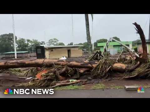
An early aerial estimate that as many as six Kaʻū bridges were half-destroyed or mostly destroyed was revised following aerial and ground inspections on August 17. Hawaiʻi County Mayor Kimo Alameda said fallen logs and trees covering the bridge channels had made the structures appear more heavily damaged than they were.
Officials said the key bridges appeared structurally intact, although engineering inspections were still required before unrestricted use. Significant flood and debris damage remained around the bridges and their approaches.
By the evening of August 17, Highway 11 access to Pāhala and Nāʻālehu had been restored for local residents and emergency or essential travel. Water, mud, boulders, vegetation and other debris had affected several sections of the highway, including areas around Nīnole Stream, Waiʻōhinu and Nāʻālehu.
Flooding, landslides, fallen trees, utility lines and windblown debris also affected roads elsewhere in the state. On Maui, Crater Road remained closed below Haleakalā National Park because of fallen trees, while Kekaulike Avenue in Kula was closed by downed utility lines.

On Oʻahu, the Pali Highway reopened in both directions after crews cleared landslides and trees, although a Kailua-bound lane remained closed for landslide mitigation. On Kauaʻi, one lane of Kūhiō Highway remained closed at the Wainiha Hairpin Turn because of a landslide.
The Hawaiʻi State Energy Office reported approximately 117 000 customers without electricity statewide at 09:00 HST on August 17. This included 71 600 customers on Oʻahu, 39 400 on Hawaiʻi Island, 6 300 in Maui County and 302 on Kauaʻi.
Hawaiian Electric reported 88 670 customers without power across Oʻahu, Maui County and Hawaiʻi Island at 18:00 HST. By 19:00 HST, island-level snapshots showed approximately 38 250 customers without service on Hawaiʻi Island, 42 450 on Oʻahu and 6 000 in Maui County.
Hawaiian Electric said outage numbers were changing as crews restored service and identified additional failures.
Hawaiʻi Island outages extended through Puna, North and South Kona, North and South Kohala, Hāmākua and South Hilo. Approximately 25 teams were assessing damage in Kohala, Upper Puna, Honokaʻa and South Kona, while three helicopters inspected transmission lines in areas where ground access was difficult.

On Maui, crews worked around Kula and other affected communities where trees, lines and poles had fallen. Hawaiian Electric said restoration in some rural areas could take longer because of access problems and the extent of infrastructure damage.
On Oʻahu, significant pole damage contributed to continuing outages. The utility asked customers from Salt Lake through East Honolulu to conserve electricity while transmission and distribution repairs continued.
Preliminary NWS observations included a gust of 225 km/h (140 mph) at the exposed Mauna Kea summit. Lower-elevation observations included 142 km/h (88 mph) near Kula, 137 km/h (85 mph) at Olowalu and 135 km/h (84 mph) at Kohala Ranch.
The winds damaged roofs and brought down trees, poles and power lines on multiple islands. State crews also reported wind and water damage at government facilities, while Nāʻālehu Elementary School sustained significant damage.

The Hawaiʻi County Department of Water Supply restored service in Pāhala, but a precautionary boil-water notice remained in effect. Potable water was being distributed from a tanker in Nāʻālehu.
The Hawaiʻi Department of Health (DOH) also issued precautionary boil-water notices for the Punaluʻu Water and Sanitation system and the Wood Valley Water and Farm Co-op Public Water System. Both systems sustained damage and lost pressure, creating the possibility that floodwater had entered their distribution networks.
A statewide Brown Water Advisory remained in effect because heavy rainfall carried sediment and possible contaminants into streams and coastal waters. DOH advised the public to avoid brown or discolored water and warned that contact with floodwater could increase the risk of infection, including leptospirosis.
Heavy rain and power failures caused several sewage releases on Oʻahu. DOH reported approximately 2.84 million L (750 000 gallons) of sewage released near Sandy Beach and more than 114 000 L (30 000 gallons) near Atkinson Drive, Ala Moana Beach Park and the Ala Wai Small Boat Harbor.
Officials said the sewage releases had stopped, but affected areas could remain contaminated.
Environmental testing was planned as conditions allowed.
A vessel-related diesel release of approximately 1 900 L (500 gallons) occurred at Māʻalaea Harbor on Maui. Responders placed a containment boom around the vessel and continued containment operations.
The Department of Land and Natural Resources reported that one vessel sank in its slip at Māʻalaea and another sank at Heʻeia Kea Harbor on Oʻahu. No boat groundings were reported, while crews assessed storm debris at the Ala Wai Boat Harbor.
Hawaiʻi Island temporarily lost 911 emergency telephone service after the storm disrupted communications infrastructure. The Hawaiʻi Police Department reported that service was restored at 16:09 HST on August 17, although telephone carriers continued to experience periodic disruptions.
An emergency shelter remained open at the Nāʻālehu Elementary School gym. State and county agencies continued coordinating shelter, food, water and recovery assistance for displaced residents.
All state and county offices, public schools, courts and other Judiciary facilities on Hawaiʻi Island remained closed on August 18. The University of Hawaiʻi at Hilo, Hawaiʻi Community College and the Kō Education Center also remained closed.
County beaches, parks and facilities were closed for the day. Most Hele-On bus services resumed, except routes 10, 12 and 90, while the Pāhala and Waiʻōhinu transfer stations remained closed.
Government offices, courts and most public schools reopened on Oʻahu, Maui and Kauaʻi, subject to individual facilities being safe and operational. Some state parks and recreational areas remained closed because of debris, power failures and water or sewer problems.
All commercial airports and harbors were open by August 17. Airlines were restoring normal schedules after earlier cancellations and delays, although state officials warned that residual flight disruptions were possible.
 Image credit: NOAA/NHC
At 05:00 HST (15:00 UTC) on August 18, the center of Hurricane Lala was approximately 630 km (390 miles) south-southeast of Maro Reef and 930 km (580 miles) southeast of Lisianski Island. Maximum sustained winds had increased to 140 km/h (85 mph), with the storm moving westward.
No tropical cyclone watches or warnings were in effect for the main Hawaiian Islands. A Hurricane Watch was in effect for portions of the Papahānaumokuākea Marine National Monument from Lisianski Island to Maro Reef, while a Tropical Storm Watch was in effect east of Maro Reef toward French Frigate Shoals.
Hawaiʻi County continued asking residents to submit residential, agricultural and commercial damage reports. Final totals for damaged buildings, roads, crops and public infrastructure remained unavailable as field inspections continued.
References:
1 Hurricane Lala Forecast Advisory 24– NOAA/NHC – 09:00 UTC on August 18, 2026
2 Storm Summary No. 4 for heavy rainfall and wind associated with Lala – NWS/WPC – August 17, 2026
3 State of Hawaiʻi Update on Tropical Storm Lala – Office of the Governor – August 17, 2026
4 Hurricane Lala recovery update – County of Hawaiʻi – August 17, 2026
Author profile
Articles

Rishav Kothari
I am an Assistant Editor and Severe Weather & Science Journalist at The Watchers, specializing in real-time severe weather coverage, geophysical event reporting, and research-driven scientific analysis. You can reach me at rishav(at)watchers(.)news.
Last edited by GaiaGoddess; 08-18-2026 at 01:08 PM.
-
08-19-2026, 01:05 PM #157Super Moderator
- Join Date
- Feb 2024
- Posts
- 4,414
Lake Powell Record Lows/The Real Data!
Credits:
Channel: The Real BPEarthWatch
Published: 8/18/26
22:37 minutes
-
08-19-2026, 01:07 PM #158Super Moderator
- Join Date
- Feb 2024
- Posts
- 4,414
U.S. Wildfire Disaster | 7.3 Million Acres Burned, New Fires Erupt
Credits:
Channel: Severe Weather USA
Published: 8/18/26
17:30 minutes
-
08-19-2026, 06:57 PM #159Super Moderator
- Join Date
- Feb 2024
- Posts
- 4,414
U.S. Weather Emergency | 60 Million Under Extreme Heat Alerts, Severe Storms & Dust Storm Threat
Credits:
Channel: Severe Weather USA
Published: 8/19/26
26:11 minutes
-
08-20-2026, 02:01 PM #160Super Moderator
- Join Date
- Feb 2024
- Posts
- 4,414
Flooding in Chile: Atacama Desert Turns Into a River as Mud Overruns the Streets of Tocopilla
Credits:
Channel: Weather Disasters
Published: 8/20/26
13:03 minutes
Summary
An extreme flood hit Tocopilla, in northern Chile, transforming streets in the Atacama Desert into corridors of water and mud. Footage taken during the disaster reveals the scale of a rare phenomenon in one of the driest regions on the planet.
In just two days, Tocopilla recorded 37.1 millimeters of rain—more than seven times its annual average, estimated at approximately 5 millimeters. Around 2,000 people were ordered to evacuate, 540 prisoners were preventively transferred, and a preliminary assessment indicated that up to 60% of homes suffered some type of flooding or impact.
In addition to images of the flooding, this video explains how a segregated low-lying area favored the formation of intense rainfall and why the extremely dry Atacama soil could not quickly absorb so much water. The result was a violent runoff, carrying mud and debris through urban areas.
Despite the extent of the damage, no deaths have been confirmed directly in Tocopilla. One death related to the storm was recorded near Taltal.
Watch until the end to understand how a relatively short storm managed to completely alter the desert landscape.
Have you ever seen a flood of this intensity in the Atacama Desert? Share your opinion in the comments and subscribe to the channel to follow new footage and explanations about extreme events around the world.
The information presented is documentary in nature and has been verified up to the date of production. Some preliminary figures may be updated by the authorities.
#chile #tocopilla #atacama desert #Manchester #ExtremeRainfall #NaturalDisasters


 Reply With Quote
Similar Threads
-
The dying of the West: Lake Mead and Lake Powell may not refill “in our lifetimes” wa
By Airbornesapper07 in forum Other Topics News and IssuesReplies: 1Last Post: 02-08-2023, 08:32 AM -
Hoover Dam, Lake Mead officers getting 52,000 rounds of ammo
By JohnDoe2 in forum Other Topics News and IssuesReplies: 1Last Post: 07-13-2015, 11:18 AM -
Boats roll on Strip to protest Lake Mead closure .... and so it begins
By AirborneSapper7 in forum General DiscussionReplies: 2Last Post: 10-08-2013, 03:01 PM -
Drought has Lake Mead at historic low
By JohnDoe2 in forum Other Topics News and IssuesReplies: 0Last Post: 11-01-2010, 01:36 PM -
Lake Mead sinks to a new historic low: Ariz. could experienc
By AirborneSapper7 in forum Other Topics News and IssuesReplies: 1Last Post: 10-20-2010, 03:37 AM


Spanish police launch operation to clear Ceuta migrants off...
09-18-2026, 09:42 PM in General Discussion