

Results 1 to 3 of 3
Thread Information
Users Browsing this Thread
There are currently 1 users browsing this thread. (0 members and 1 guests)
 LinkBack URL
 About LinkBacks
-
08-29-2014, 11:54 PM #1Senior Member


- Join Date
- May 2007
- Location
- South West Florida (Behind friendly lines but still in Occupied Territory)
- Posts
- 117,696
WOTUS: Is America all wet to EPA? Is there anywhere EPA doesn't hope to regulate
 CFACT
CFACT
Is there anywhere EPA doesn't hope to regulate as wetlands if it succeeds in redefining what constitutes "waters of the United States" (WOTUS) subject to the Clean Water Act?
Share the facts at CFACT.org: http://www.cfact.org/?p=22792
Sign CFACT's statement to EPA: https://secure.giveworks.net/cfact/WOTUS/CFACT82814
Congressman Lamar Smith released a series of wetlands maps he received from a FOIA request to EPA and said, "These maps show EPAs plan: to control a huge amount of private property across the country. Given the astonishing picture they paint, I understand the EPAs desire to minimize the importance of these maps. But the EPAs posturing cannot explain away the alarming content of these documents."
EPA says not to worry. It still hasn't drawn final maps showing what land it can control under the CWA.
When it comes time to decide whose land it can regulate, should we count on EPA to exhibit moderation and restraint?

WOTUS: Is America all wet to EPA?
August 28, 2014 by CFACT Ed, 0 Comments
Congressman Lamar Smith, Chairman of the House Science, Space, and Technology Committee, posted a series of maps he obtained via a FOIA request that EPA is using to plot wetlands.
cfact.org
WOTUS Is America all wet to EPA?

August 28, 2014 by CFACT Ed, 5 Comments
 Congressman Lamar Smith, Chairman of the House Science, Space, and Technology Committee, posted a series of maps he obtained via a FOIA request that EPA is using to plot wetlands.
Wetlands are a particularly sensitive issue right now as EPA evaluates its proposed rule to broaden what constitutes waters of the United States (WOTUS). The new rule would bring huge new territory under EPAs control under the Clean Water Act.
Smith wrote a letter to EPA Administrator Gina McCarthy in which he stated:These maps show EPAs plan: to control a huge amount of private property across the country. Given the astonishing picture they paint, I understand the EPAs desire to minimize the importance of these maps. But the EPAs posturing cannot explain away the alarming content of these documents. Its time to give Americans a chance to make up their own minds about EPAs intentions.Smith called on EPA to publish the maps and include them in public comment on EPAs WOTUS rule. He asked EPA to reset the clock for offering public comment to 60 days after EPA officially releases the maps to the public.
For many regions of the United States, its hard to find much land that these maps exclude from what EPA may consider wetlands.
 Nancy Stoner
EPA Acting Assistant Administrator Nancy Stoner defended the maps in a letter to Smith in which she said the maps were prepared, to better understand the potential impacts of certain court decisions to aquatic resources, but not to depict the scope of waters protected under the Clean Water Act.
Should American citizens concerned about how much of the land depicted in these maps EPA hopes to regulate under its new WOTUS rule be reassured by EPAs recent record of moderation and restraint?
You can sign CFACTs statement to EPA on the Waters
 of the United States here. Unless EPA heeds Smiths request and extends the deadline, we have until October 20th to sign on as many concerned citizens as possible.

About the Author: CFACT Ed
http://www.cfact.org/2014/08/28/wotu...ll-wet-to-epa/Join our efforts to Secure America's Borders and End Illegal Immigration by Joining ALIPAC's E-Mail Alerts network (CLICK HERE)
-
09-02-2014, 05:34 PM #2Senior Member
- Join Date
- May 2007
- Location
- South West Florida (Behind friendly lines but still in Occupied Territory)
- Posts
- 117,696
CFACT
Check out all ten of EPA's regional wetlands maps and see what new regulations could be headed for you.
How much land does EPA intend to regulate as waters of the United States (WOTUS) if it gets its new rule?
Share the facts at CFACT.org: http://www.cfact.org/2014/09/02/wotu...-wetland-maps/
... Sign CFACT's statement to EPA and ditch the rule! https://secure.giveworks.net/cfact/WOTUS/CFACT82814
WOTUS All ten of EPAs regional wetland maps

September 2, 2014 by CFACT Ed, 1 Comment
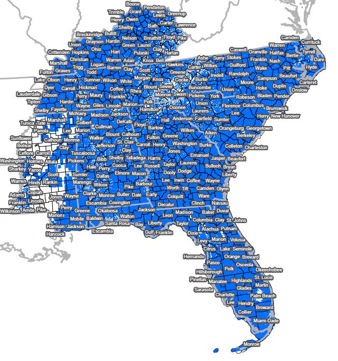
Per multiple requests here are all ten of EPAs regional wetlands maps.
Click for expanded view.

EPA wetlands map region 1

EPA wetlands map region 2

EPA wetlands map region 3
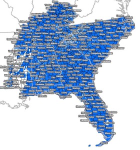
EPA wetlands map region 4

EPA wetlands map region 5

EPA wetlands map region 6

EPA wetlands map region 7

EPA wetlands map region 8

EPA wetlands map region 9

EPA wetlands map region 10
Sign CFACTs statement to EPA and ditch the rule!

Categories
http://www.cfact.org/2014/09/02/wotu...-wetland-maps/Join our efforts to Secure America's Borders and End Illegal Immigration by Joining ALIPAC's E-Mail Alerts network (CLICK HERE)
-
09-02-2014, 05:40 PM #3Senior Member
- Join Date
- May 2007
- Location
- South West Florida (Behind friendly lines but still in Occupied Territory)
- Posts
- 117,696
Blueprint for water control? Pol says EPA made secret maps for new regulatory push

By Judson Berger
Published August 27, 2014FoxNews.com
Blueprint for water control? Pol says EPA made secret maps for new regulatory push

Blueprint for water control? Pol says EPA made secret maps for new regulatory pushThe Environmental Protection Agency secretly drafted highly detailed maps of waterways in all 50 states while pushing a ...http://fxn.ws/1qh2lTV
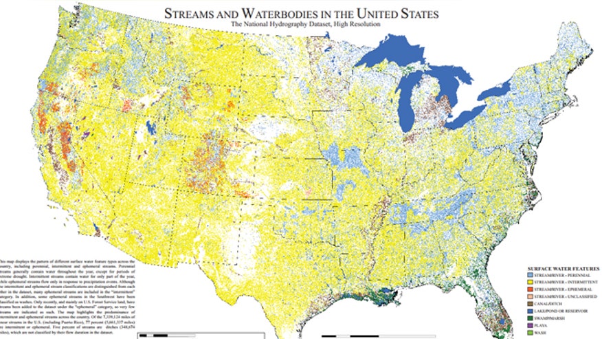
Shown here is one of the many maps commissioned by the EPA to detail U.S. waterways.EPA
A top House Republican is charging that the Environmental Protection Agency secretly drafted highly detailed maps of U.S. waterways to set the stage for a controversial plan to expand regulatory power over streams and wetlands, a claim the EPA strongly denies.
Rep. Lamar Smith, R-Texas, chairman of the House Science, Space, and Technology Committee, released those maps on Wednesday, while firing off a letter to EPA Administrator Gina McCarthy voicing concerns over why they were created in the first place.
"These maps show the EPA's plan: to control a huge amount of private property across the country. Given the astonishing picture they paint, I understand the EPA's desire to minimize the importance of these maps," he wrote, in the letter obtained by FoxNews.com.
But an EPA spokeswoman said the maps, from the U.S. Geological Survey and Fish and Wildlife Service, do not depict which waters are subject to EPA control.
"Let us be very clear -- these maps have nothing to do with EPA's proposed rule or any other regulatory purpose," Liz Purchia said, noting they were initially created years ago and subsequently updated.
At issue is a proposal that Smith and fellow Republicans, as well as farmers and other groups, say could endanger private property rights by giving the EPA a say over temporary waterways like seasonal streams, under the Clean Water Act. That the agency had highly detailed maps drawn up has raised suspicion about their purpose.
"While the Agency marches forward with a rule that could fundamentally re-define Americans' private property rights, the EPA kept these maps hidden," Smith wrote in his letter. "Serious questions remain regarding the EPA's underlying motivations for creating such highly detailed maps."
He added: "The EPA's job is to regulate. The maps must have been created with this purpose in mind."
The high-resolution maps of each state depict a dense and veiny web of intertwining waterways. They're color-coded to distinguish everything from canals and ditches to reservoirs to marshes to various types of streams. The maps show permanent streams, but also those that contain water for only part of the year.
The EPA denied the maps were drawn to chart areas subject to the Clean Water Act. The agency said they were only drawn to identify the "extent and location" of waterways and other details.
In two letters to Smith, in late July and early August, EPA Deputy Assistant Administrator Nancy Stoner explained the documents were originally prepared in 2005, and updated last year with data from the U.S. Geological Survey.
"EPA is not aware of maps prepared by any agency, including the EPA, of waters that are currently jurisdictional under the CWA or that would be jurisdictional under the proposed rule," she wrote, adding that the maps would have to be even more detailed to be used for that purpose.
Decisions over whether the EPA has authority over "particular waters," Purchia said, are almost always made in response to requests. She told FoxNews.com the maps in question would have to involve ground surveys to actually reflect the proposed rule, which she called "prohibitively expensive."
But the map details would appear to dovetail with the type of waterways the agency is looking at regulating.
Since last year, the EPA has floated new rules that would define what kinds of waterways fall under its jurisdiction. The Clean Water Act already gives the EPA the ability to regulate "U.S. waters," but Supreme Court rulings have left the specifics unclear when it comes to waters that flow only part of the year.
To address that, the EPA and Army Corps of Engineers want to define that authority -- and are eyeing waterways deemed to have some significant connection to major rivers, lakes and other systems.
The EPA claims this does not expand its authority, and only clarifies it.
But detractors claim this is an opening for the EPA to claim authority over countless waterways, including streams that only show up during heavy rainfall. Critics warn this could create more red tape for property owners and businesses if they happen to have even small streams on their land.
A House science committee aide called the EPA maps "eye-opening" for those following the process.
"These are not everyday, run-of-the-mill maps -- these are highly detailed," the aide told FoxNews.com, adding that the agency had not previously disclosed the documents for public comment.
The committee only learned about the maps after hearing from the U.S. Geological Survey that the EPA was having them drawn up. Lawmakers subsequently asked then-EPA Deputy Administrator Bob Perciasepe about them at a hearing last month, and he agreed to release them.
Smith, in his letter, also questioned why the agency used taxpayer money to create the maps. He asked the agency to provide all documents related to its contract for the maps, turn over any other previously undisclosed maps, and extend the comment period for at least another two months.
Under the current plan, the comment period is projected to close on Oct. 20.
http://www.foxnews.com/politics/2014...-maps-for-new/Join our efforts to Secure America's Borders and End Illegal Immigration by Joining ALIPAC's E-Mail Alerts network (CLICK HERE)


 Reply With Quote


Similar Threads
-
California Liberals Pass Bill to Regulate Sex & Show America the Control Freaks They
By AirborneSapper7 in forum Other Topics News and IssuesReplies: 0Last Post: 06-06-2014, 01:42 AM -
UN TO REGULATE DISABLED PEOPLES RIGHTS IN AMERICA
By AirborneSapper7 in forum Other Topics News and IssuesReplies: 1Last Post: 07-19-2012, 03:22 AM -
County Sheriff-America's last hope..
By partwerks in forum Other Topics News and IssuesReplies: 0Last Post: 02-21-2010, 08:14 PM -
hope this doesn't piss anybody off
By againstillegals in forum General DiscussionReplies: 8Last Post: 04-16-2006, 05:17 PM


GALLUP POLL: Immigration the most pressing issue in America for...
05-03-2024, 11:30 PM in General Discussion